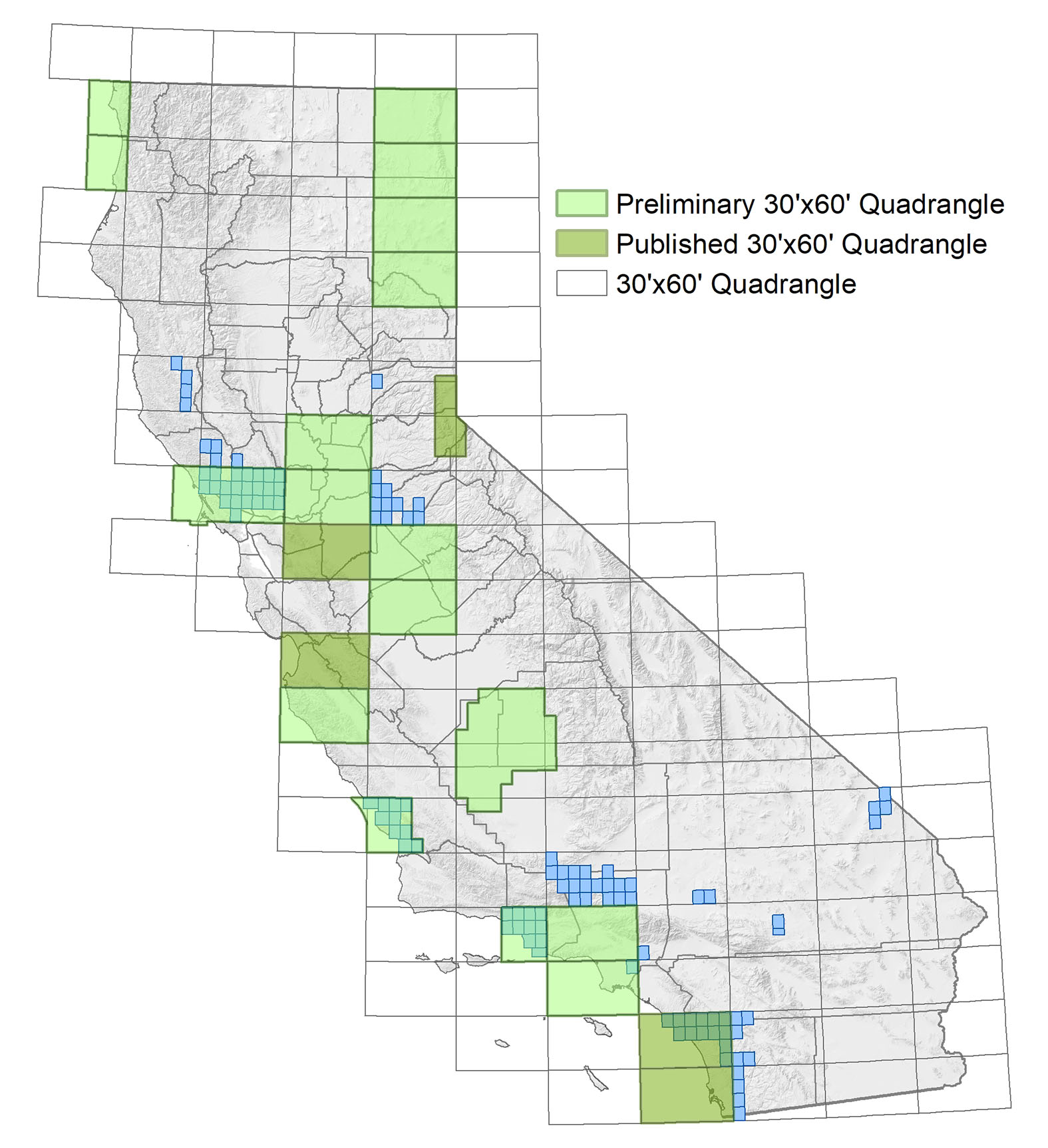
California Regional Geologic Maps

​​​​​​​Current Regional Geologic Map Series (1981-Present)

For decades the Geologic Atlas of California (discussed in the next section) has been the primary source of regional-scale geologic maps in California. In an effort to keep the maps current, the CGS has been compiling a new series of Regional Geologic Maps (RGM), starting in 1981. The new maps cover the same areas as the older Geologic Atlas of California, but show more detail and use geologic formations rather than the simplified geologic time-based units.

The CGS published the first six maps of this series at 1:250,000 scale. After 1992, we began producing more detailed, larger scale maps (1:100,000 and 1:24,000 scales). To date, there are more than 100 new or updated geologic maps in the current RGM series: ten are officially Published, while the remainder are still considered Preliminary (see the sidebar below regarding Preliminary Regional Geologic Maps).

Sidebar: Preliminary Regional Geologic Maps

The California Geological Survey has several new and updated geologic maps that are considered preliminary. We make digital versions of these preliminary maps available before publication so you may have timely access to the information. Follow this link to explore our collection of Preliminary Regional Geologic Maps.

You can download Published maps of the current Regional Geologic Map series using the links provided below. Printed versions can be purchased from the CGS Publications sales desk.

Published 30-by-60 minute quadrangles (1:100,000 scale)

Lake Tahoe Basin, 2005 (RGM 4)
Monterey, 2002 (RGM 1)
Oceanside, 2007 (RGM 2)
San Diego, 2008 (RGM 3)
For additional 30-by-60 minute quadrangles (1:100,000 scale) and 7.5 minute quadrangles (1:24,000 scale), visit our Preliminary Geologic Maps page
Below: Index map showing availability of Published and Preliminary maps of the current Regional Geologic Map series at 1:100,000 and 1:24,000 scales. Click or tap the image to see a larger version.
Map of California showing available quadrangles as summarized in the figure caption.

Published 1-by-2 and 1-by-3 degree quadrangles (1:250,000 scale)

Chico, 1992 (RGM 7A)
Sacramento, 1981 (RGM 1A)
San Bernardino, 1986 (RGM 3A)
San Francisco-San Jose, 1991 (RGM 5A)
Santa​ Rosa, 1982 (RGM 2A)
Weed, 1987 (RGM 4A)

The Geologic Atlas of California (1958-1969)

The Geologic Atlas of California was published between 1958 and 1969. Although more recent and more detailed mapping is available in many areas (see Current Regional Geologic Map Series, above), this set of maps is still the most detailed interpretation available for the entire state. It provides a complete, consistent view of the geology of the state, prepared at 1:250,000 scale. The Geologic Atlas uses a single set of rock units defined by geologic time, rather than geologic formations defined by time and lithology. This allows a simplified, uniform depiction of geologic units.

The following index map and list provide the areas covered by the individual sheets of the Geologic Atlas. You can download maps from the Geologic Atlas of California using the links provided in the list.​​

Below: Index map showing areas covered by the individual sheets of the Geologic Atlas of California.
Map of California showing quadrangles of the Geologic Atlas of California.

Alturas, 1958 (GAM 1)

Bakersfield, 1964 (GAM 2)

Chico, 1962 (GAM 3)

Death Valley, 1974 (GAM 4)

Fresno, 1965 (GAM 5)

Kingman, 1961 (GAM 6)

Long Beach, 1962 (GAM 7)

Los Angeles, 1969 (GAM 8)

Mariposa, 1967 (GAM 9)

Needles, 1963 (GAM 10)

Redding, 1962 (GAM 11)

Sacramento, 1965 (GAM 12)

Salton Sea, 1967 (GAM 13)

San Bernardino, 1967 (GAM 14)

San Diego-El Centro, 1962 (GAM 15)

San Francisco, 1961 (GAM 16)

San Jose, 1966 (GAM 17)

San Luis Obispo, 1958 (GAM 18)

Santa Ana, 1965 (GAM 19)

Santa Cruz (Monterey), 1958 (GAM 20)

Santa Maria, 1959 (GAM 21)

Santa Rosa, 1963 (GAM 22)

Trona, 1962 (GAM 23)

Ukiah, 1960 (GAM 24)

Walker Lake, 1963 (GAM 25)

Weed, 1963 (GAM 26)

Westwood, 1960 (Susanville) (GAM 27)

Statewide Geologic Map and Fault Activity Map of California (2010)

CGS prepared these editions of the Geologic Map of California and the Fault Activity Map of California in recognition of the California Geological Survey’s 150th Anniversary.

Click either image to learn more.


Web page by:
California Geological Survey - Regional Geologic and Landslide Mapping Program


 ‭(Hidden)‬ Custom CSS