The California Geological Survey (CGS) is conducting geochemical reconnaissance sampling for critical minerals in California. This web page contains the results of those reconnaissance efforts.
The goal of the sampling program is to collect data that will support current and future critical-mineral, precious-metal, base-metal, and industrial-mineral activities in California. Critical minerals as defined by the U.S. Department of Interior are mineral resources that are essential to our economy and national security and are at risk for supply disruption.
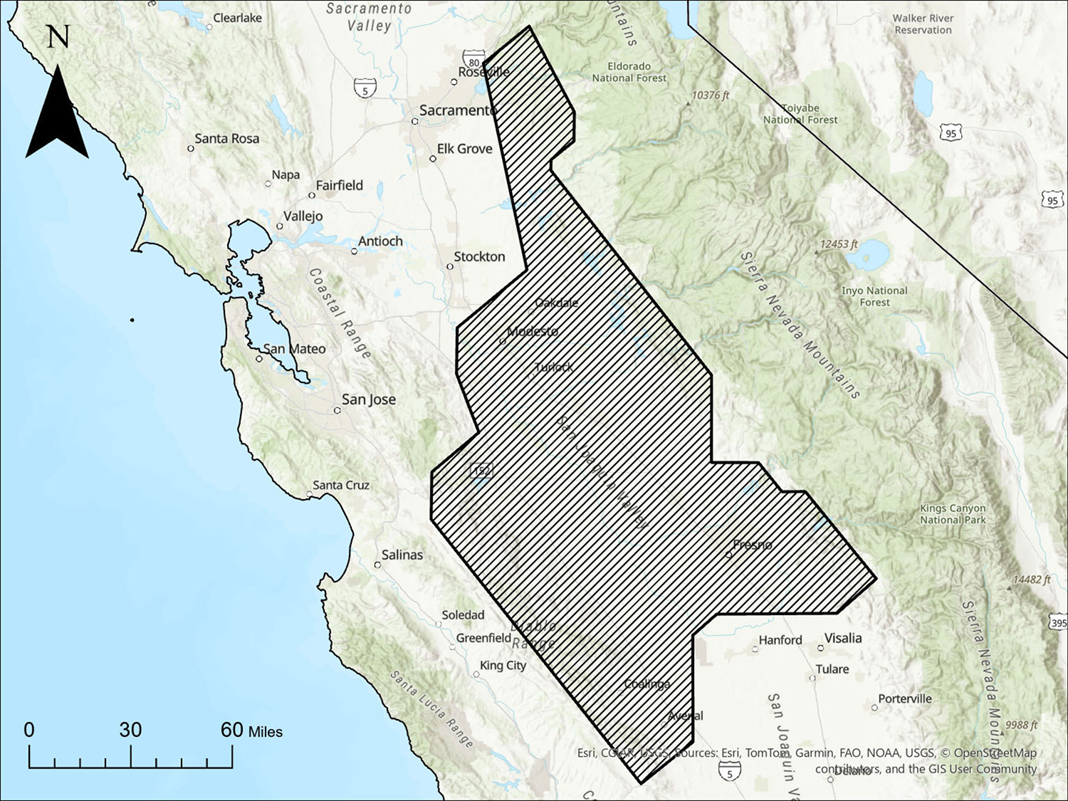
DR 2026-04 - Data Release for Airborne Magnetic and Radiometric Geophysical Survey of a portion of the northern San Joaquin Valley, California
Map showing location and area of the Airborne Magnetic and Radiometric Geophysical Survey of a portion of the northern San Joaquin Valley, California.
By Angela Gerhardt, PG., Kazumi Nakamura, PhD, PG, Lennin Escobar, and Josh Coyan, PhD
Summary of DR 2026-04
The California Geological Survey (CGS) contracted Terraquest Ltd., to acquire high-resolution airborne magnetic and radiometric data over approximately 30,365 square kilometers in the northern San Joaquin Valley, California. The survey was flown between June 2024 and April 2025 and included 1,052 traverse lines oriented 050º/230º and spaced 300 meters apart and 60 control lines oriented 140º/320º oriented and spaced 3,000 meters apart, for a total of 111,351 line-kilometers of data collection.
The survey was conducted to expand high-resolution geophysical data coverage in California and improve understanding of the geologic framework in the region. Airborne magnetic data can help delineate variations in subsurface geology and geologic structures, while radiometric data provide information about the distribution and composition of rocks and materials at or near the ground surface. Together these datasets support rock identification, geologic and geophysical mapping, and characterization of surface and subsurface geology. The data were collected to support a variety of geologic investigations, including efforts to identify and characterize areas that may be suitable for geologic carbon sequestration.
This data release provides the airborne magnetic and radiometric survey data and associated contractor deliverables. The data are released as collected and processed by the contractor and do not include geologic interpretations by CGS.
Suggested citation:
Gerhardt, A.M., Nakamura, K., Escobar, L., and Coyan, J.A, 2026, Airborne Magnetic and Radiometric Geophysical Survey of a portion of the northern San Joaquin Valley, California, DR 2026-4. California Department of Conservation, California Geological Survey data release, https://conservation.ca.gov/cgs/publications/data-releases.
DR 2026-03 - Data Release for Airborne Magnetic and Radiometric Geophysical Survey of a portion of the southern San Joaquin Valley, California
Map showing location and area of the Airborne Magnetic and Radiometric Geophysical Survey of a portion of the southern San Joaquin Valley, California.
By Angela Gerhardt, PG., Kazumi Nakamura, PhD, PG, Lennin Escobar, and Josh Coyan, PhD
Summary of DR 2026-03
The California Geological Survey (CGS) contracted Terraquest Ltd., to acquire high-resolution airborne magnetic and radiometric data over approximately 9,400 square kilometers in the southern San Joaquin Valley, California. The survey was flown between Fall 2022 and Spring 2023 and included 499 east-west traverse lines spaced 250 meters apart and 41 north-south control lines spaced 2,500 meter apart, for a total of 41,783 line-kilometers of data collection.
The survey was conducted to expand high-resolution geophysical data coverage in California and improve understanding of the geologic framework in the region. Airborne magnetic data can help delineate variations in subsurface geology and geologic structures, while radiometric data provide information about the distribution and composition of rocks and materials at or near the ground surface. Together these datasets support rock identification, geologic and geophysical mapping, and characterization of surface and subsurface geology. The data were collected to support a variety of geologic investigations, including efforts to identify and characterize areas that may be suitable for geologic carbon sequestration.
This data release provides the airborne magnetic and radiometric survey data and associated contractor deliverables. The data are released as collected and processed by the contractor and do not include geologic interpretations by CGS.
Suggested citation:
Gerhardt, A.M., Nakamura, K., Escobar, L., and Coyan, J.A., 2026, Airborne Magnetic and Radiometric Geophysical Survey of a portion of the southern San Joaquin Valley, California, DR2026-3. California Department of Conservation, California Geological Survey data release,https://conservation.ca.gov/cgs/publications/data-releases.
DR 2026-02 - Data Release for Airborne Magnetic and Radiometric Geophysical Survey of the Klamath Mountains Geomorphic Province in Northern California
Map showing location and area of the Airborne Magnetic and Radiometric Geophysical Survey in the Klamath Mountains, northern California.
By Angela Gerhardt, PG., Kazumi Nakamura, PhD, PG, Lennin Escobar, and Josh Coyan, PhD
Summary of DR 2026-02
The California Geological Survey (CGS) contracted Xcalibur MPH Canada Ltd., to acquire high-resolution airborne magnetic and radiometric data over portions of the Klamath Mountains province in northern California. The survey was flown between October 2023, and May 2024 and included approximately 94,476 line-kilometers of traverse lines spaced 250 meters apart and 9447 line-kilometers of tie lines spaced 2,500 meters apart, for a total of 103,920 line-kilometers of data collection.
The survey was conducted to expand high-resolution geophysical data coverage in California and improve understanding of the geologic framework in the region. Airborne magnetic data can help delineate variations in subsurface geology and geologic structures, while radiometric data provide information about the distribution and composition of rocks and materials at or near the ground surface. Together these datasets support rock identification, geologic and geophysical mapping, and characterization of surface and subsurface geology. The data were collected to support a variety of geologic investigations, including efforts to identify and characterize areas that may be suitable for geologic carbon sequestration.
This data release provides the airborne magnetic and radiometric survey data and associated contractor deliverables. The data are released as collected and processed by the contractor and do not include geologic interpretations by CGS.
Suggested citation:
Gerhardt, A.M., Nakamura, K., Escobar, L., and Coyan, J.A., 2026, Airborne Magnetic and Radiometric Geophysical Survey of the Klamath Mountain geomorphic province in northern California, DR2026-2. California Department of Conservation, California Geological Survey data release, https://conservation.ca.gov/cgs/publications/data-releases.
DR 2026-01 – Geochronology and Geochemistry Data Release for the New York Mountains Earth MRI Project, San Bernardino County, California: U-Pb Radiometric Dating, Luminescence Dating, and Geochemistry
Map showing geochronologic and geochemical sample sites relative to the four topographic quadrangles (black outlines) included in the CGS Mineral Resources Program Earth MRI mapping project for the New York Mountains. The project area is in eastern San Bernardino County, adjacent to the California-Nevada border.
Compiled by Brian J. Swanson (CGS), PG, CEG, David Reioux (CGS), PG, Benjamin M. Parrish (CGS), PG, Matthew J. Towne (CGS), Joshua J. Schwartz (CSUN), and Shannon A. Mahan (USGS)
Summary of DR 2026-01
As part of the CGS Mineral Resources Program Earth MRI mapping project for four quadrangles in the New York Mountains, CGS staff collected samples of rocks ranging in age from Proterozoic to Mesozoic for U-Pb radiometric dating and geochemical analyses. The Proterozoic rocks in the New York Mountains a re closely related to the rocks that host the Mountain Pass Rare Earth Element (REE) deposits in the Clark Range, northwest of the study area. Proterozoic and Mesozoic rocks containing gold and other precious metals also occur within the historic Vanderbilt mining area in the New York Mountains. The U-Pb dating and geochemical analyses can be used to constrain the timing of the Kokoweef and Ivanpah orogenies and identify areas with mineral-resource potential. Samples of older alluvial-fan sediments were collected for Infrared Stimulated Luminescence (IRSL) dating, which can be used to better understand the Quaternary history of the area and help identify areas susceptible to debris flow hazards.
DR 2024-1 - Data Release for the Del Norte Nickel-Cobalt Laterite Geochemical Reconnaissance Project
Map showing location and size of reconnaissance area (black outline), and distribution of sample locations (blue dots). Location: north-central Del Norte County. Size: roughly 15 miles across in all directions. There are approximately 90 sample locations, distributed toward the perimeter of the recon area.
by Ben Parrish, PG and Amy Tuzzolino, PG
Summary of DR 2024-1
The CGS conducted geochemical reconnaissance sampling of laterite and associated ultramafic rocks in Del Norte County as part of its statewide geochemical reconnaissance initiative. The Del Norte County laterite deposits have historically been mined for nickel, cobalt, and chromium. Samples from laterite and ultramafic rocks of the Josephine Ophiolite in Del Norte County were collected for geochemical analyses. Samples were selected to evaluate trace-element signatures and distribution in laterite deposits and compare trace-element concentration in underlying ultramafic rocks. Samples were also selected to evaluate laterite enrichment processes for nickel, cobalt, and chromium in these deposits.