The winter of 2022-23 will be a memorable one for California. From December through March, fourteen atmospheric rivers had drenched most of the state. Governor Gavin Newsom issued a disaster declaration for 40 counties as the deluge of rainfall caused flooding and landslides. Hundreds of shallow landslides were documented, and in the immediate aftermath of the storms several deep-seated landslides failed, leading to condemned homes, severed lifelines, and evacuated communities.
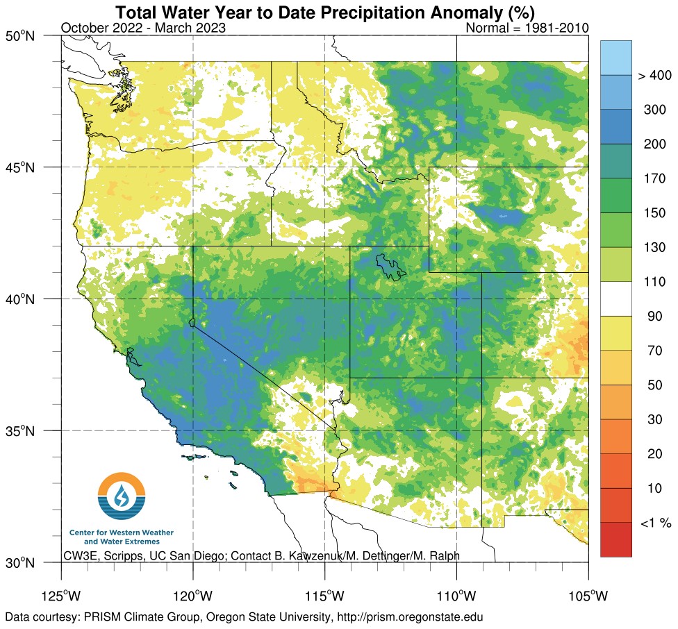 Precipitation observations. By April 1, a broad swath of central California had received more than 150% of average precipitation for the wet season to-date. Some areas received more than 200% of average. Click the image to open a larger version in a new window. Source: Center For Western Weather and Water Extremes. Updated April 10, 2023.
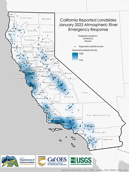 Reported landslides. In January the California Geological Survey and the U.S. Geological Survey inventoried more than 700 landslides, many of them reported by the public. Note: the map only shows reported landslides. Click the image to open a larger version in a new window.
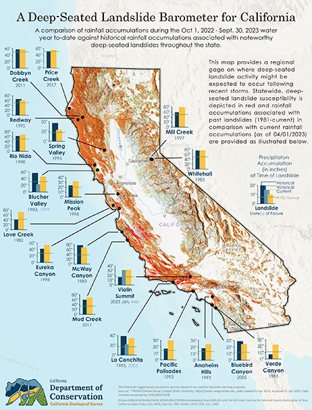 Deep-seated landslide barometer. Several noteworthy deep-seated landslides have occurred in the past. This map compares the amount of rainfall that contributed to their failure against rainfall accumulated during the 2022–2023 water year to-date. Click the image to open a larger version in a new window. Updated April 4, 2023.
What is a Deep-Seated Landslide?
Deep-seated landslides differ from other types, such as debris flows or rock falls, in that they are not necessarily triggered by any single storm or earthquake. Instead, they occur weeks to months after heavy rainfall ends, when water has had time to percolate deeper under the surface to saturate weak zones of rock, creating a “landslide plane" under the saturated weight of the overlying rock and soil. This landslide plane may often be associated with earlier slides. It is important to remember that these landslides can occur regardless of whether rain is falling or not.
Because these landslides begin so deeply, they tend to carry more material and cover more territory than other types of slides. Deep-seated landslides generally occur on moderately steep slopes, often travel much slower than debris flows or mudflows (maybe only a few inches a day), and can continue for several days.
Notable Deep-Seated Landslides: Bluebird Canyon and La Conchita
Perhaps the best-known deep-seated landslides occurred at La Conchita in Ventura County and Bluebird Canyon in Laguna Beach, Orange County. Each location had experienced significant rain in the months preceding the events, and more recent storms proved to be the catalysts for calamity.
Bluebird Canyon (1978 and 2005)
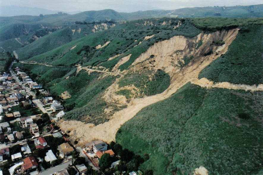
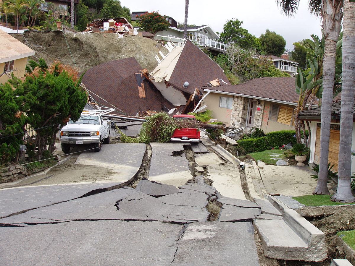 2005 Bluebird Canyon landslide, Orange County. Numerous houses along a portion of Flamingo Road were destroyed when the south-facing hillside above Bluebird Canyon Drive in Laguna Beach failed and slid downhill months after heavy winter rains. Click the image to open a larger version in a new window. Photo by Pam Irvine, CGS.
Bluebird Canyon suffered a landslide that killed two people and damaged 300 homes in October 1978, months after the heavy March storms that are believed to be a contributing factor to the failure. On June 1, 2005, another disaster hit the community when a slide sent 18 homes, each valued at more than $1 million, crashing down a hillside. The 2005 event occurred just up-canyon of the 1978 failure and also occurred after months of substantial rainfall, with a winter that saw over 30 inches of rain in southern California.
La Conchita (1995)
 La Conchita landslide, Ventura County. A large section of the hillside slid down and buried several homes after receiving almost 30 inches of rain that winter. Photo taken March 8, 1995. Click the image to open a larger version in a new window. Photo by Pam Irvine, CGS.
In La Conchita, located on a narrow strip of land between the Pacific Ocean and an 800-foot bluff, two landslides, days apart in March 1995, covered an area of nearly 10 acres with 1.7 million cubic yards of material. The slides buried several houses and damaged others without loss of life. However, a landslide on January 10, 2005 caused 10 deaths, destroying 13 homes and severely damaging 23 others. Triggered by two weeks of torrential rain, the 2005 slide was a shallower, smaller landslide (about 261,000 cubic yards) atop the earlier, deeper slide area.
Near a Slope? Know the Signs of a Deep-Seated Landslide
There is some good news: The reason no one perished during the 1995 La Conchita landslides is that unlike earthquakes, impending deep-seated landslides often provide warnings. Residents atop, on, or at the bottom of sloped areas are advised to know the signs, look for them, and contact local authorities if they are concerned about the potential for landslides. In the weeks and months after heavy rainfall:
- Check for new cracks in the soil, structural shifts in your home (doors/windows that suddenly don't close properly, for example), the appearance of holes or bare spots on hills, tilting trees or bulges at the base of slopes, or material moving downhill.
- Watch for new springs or seeps and excess surface erosion on slopes on and around your property. If there are nearby streams, do they appear muddier than normal?
- Listen for unusual rumbling sounds or noises that may indicate moving earth and rocks or breaking vegetation or structures.
- Likewise, broken water and gas lines or noises in your plumbing may indicate that pipes are being pulled apart.
More Reading
Web page by:
California Geological Survey - Regional Geologic and Landslide Mapping Program
