 A ShakeMap is a representation of ground shaking produced by an earthquake. The information it presents is different from the earthquake magnitude and epicenter that ar e released after an earthquake because ShakeMap focuses on the ground shaking produced by the earthquake, rather than the parameters describing the earthquake source. So, while an earthquake has one magnitude and one epicenter, it produces a range of ground shaking levels at sites throughout the region depending on distance from the earthquake, the rock and soil conditions at sites, and variations in the propagation of seismic waves from the earthquake due to complexities in the structure of the Earth's crust.
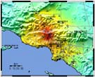
The California Integrated Seismic Network (CISN) Real-Time ShakeMaps include maps of measured ground motion (peak acceleration and velocity) obtained from seismic networks, and maps of shaking intensity estimated using these measurements. Maps are posted approximately 10 minutes after California earthquakes of Magnitude 3.5 and larger.
