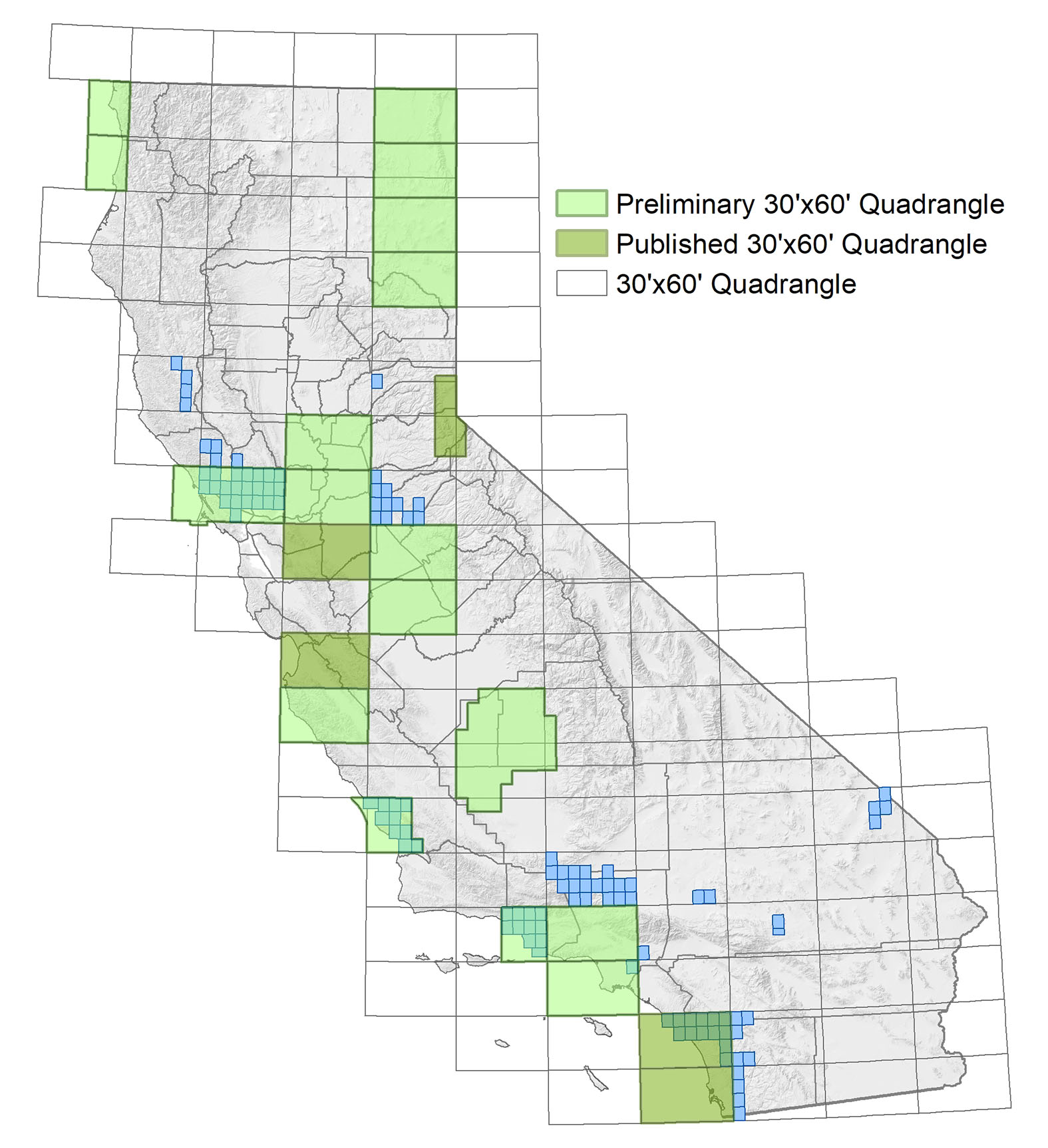
 Above: Index map showing available quadrangles of the modern California Regional Geologic Map series. Smallest squares represent 7.5 minute quadrangles (1:24,000 scale). Larger rectangles represent 30-by-60 minute quadrangles (1:100,000 scale). Click or tap the image to open a larger version.
The maps on this page are considered preliminary. We make digital versions of preliminary maps available to provide timely access to the information. Maps can be downloaded using the links provided below. Please note, preliminary maps are available as PDF files only. Printed versions are not available.
Geologic map preparation at the CGS generally follows a three-step process. First, we complete selected 7.5-minute quadrangles at 1:24,000 scale. Then we compile this mapping into 30-by-60-minute quadrangles at 1:100,000 scale; the 7.5-minute and initial 30-by-60-minute quadrangles are published in our Preliminary Geologic Map series. Following a period of review, 30-by-60-minute quadrangles are elevated into the Regional Geologic Map series as the third step in the process, with the long-term goal of creating a seamless digital geologic map of the state at a scale of 1:100,000.
The California Geological Survey prepares geologic maps in cooperation with the U.S. Geological Survey's National Cooperative Geologic Mapping Program. Geologic mapping priorities are established by the California State Geologist and the California Geologic Mapping Advisory Committee.
For data requests and technical comments related to Geologic Mapping, please contact Brian Swanson.
Preliminary 30-by-60 Minute Quadrangles (1:100,000 scale)
Preliminary 7.5 Minute Quadrangles (1:24,000 scale)
Select a region from the choices below to jump to a list of that region's 7.5 minute quadrangles.
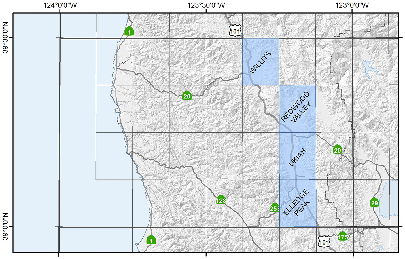
Ukiah Region
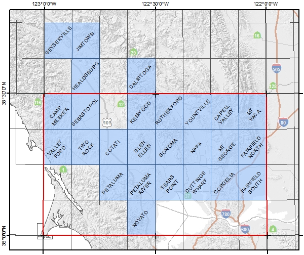
Healdsburg-Napa Region
Note: The 7.5 minute quadrangles within the Napa 30-by-60 minute quadrangle (outlined in red below) have been updated and are superseded by the Preliminary Geologic Map of the Napa-Bodega Bay 30-by-60 minute quadrangle (Wagner and Gutierrez, 2017).
-
Calistoga, 2013 (4.1 MB)
-
Camp Meeker, 2009 (7.2 MB)
-
Capell Valley, 2006 (7.7 MB)
-
Cordelia, 1998 (3.6 MB)
-
Cotati, 2003 (4.2 MB)
-
Cuttings Wharf, 2002 (3.0 MB)
-
Fairfield North, 2006 (6.2 MB)
-
Fairfield South, 1998 (2.7 MB)
-
Geyserville, 2012 (3.6 MB)
-
Glen Ellen, 2003 (5.4 MB)
-
Healdsburg, 2011 (8.2 MB)
-
Jimtown, 2010 (9.0 MB)
-
Kenwood, 2007 (2.4 MB)
-
Mt. George, 2004 (3.4 MB)
-
Mt. Vaca, 2007 (2.8 MB)
-
Napa, 2004 (3.8 MB)
-
Novato, 2002 (2.3 MB)
-
Petaluma, 2002 (2.5 MB)
-
Petaluma River, 2002 (1.6 MB)
-
Rutherford, 2005 (11 MB)
-
Sears Point, 2002 (2.0 MB)
-
Sebastopol, 2008 (3.7 MB)
-
Sonoma, 2004 (3.7 MB)
-
Two Rock, 2003 (4.0 MB)
-
Valley Ford, 2008 (4.6 MB)
-
Yountville, 2005 (10 MB)
Truckee Region

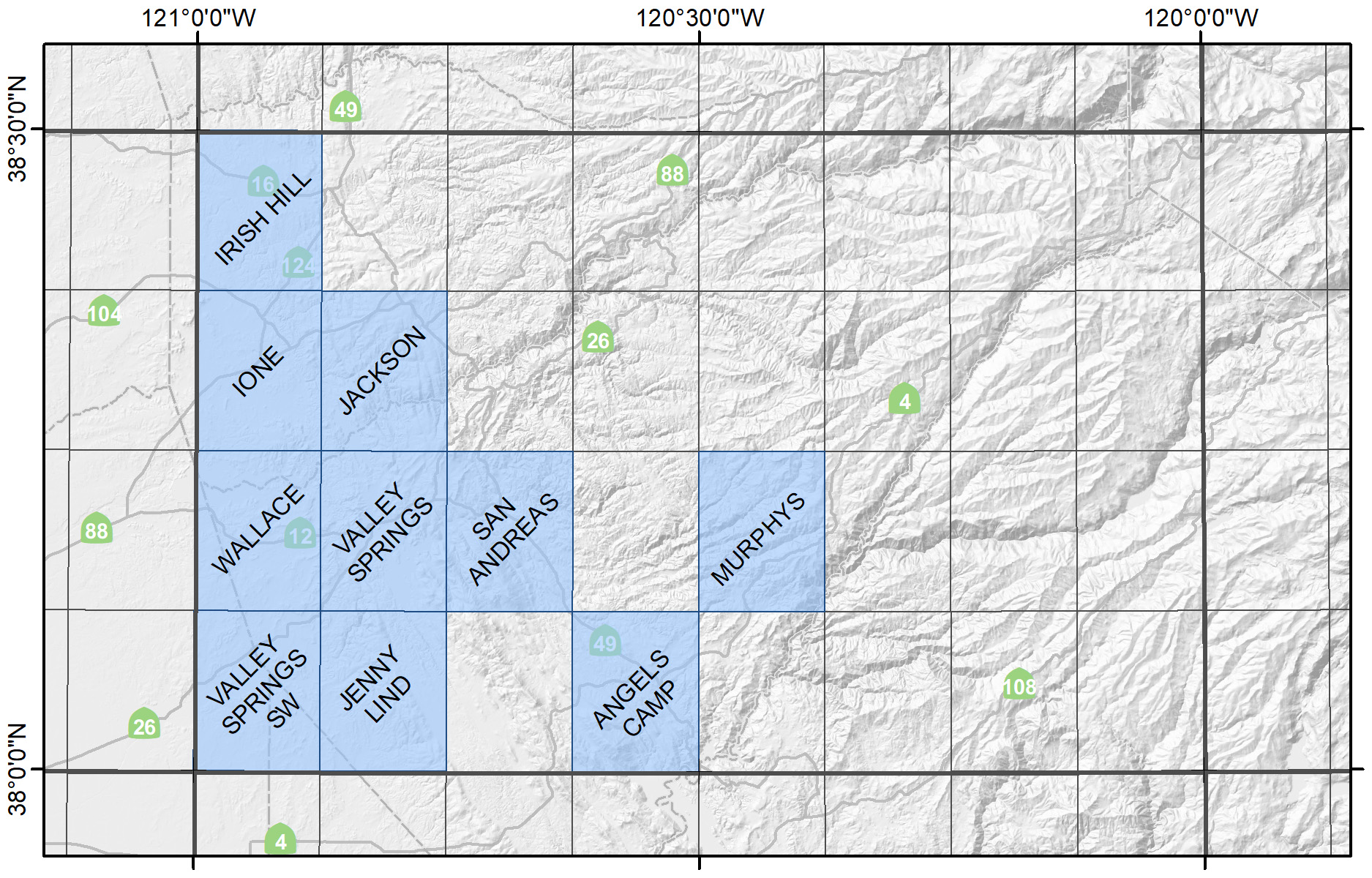
San Andreas Region
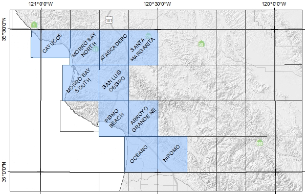
San Luis Obispo Region
Note: The 7.5 minute quadrangles shown below have been updated and are superseded by the Preliminary Geologic Map of the West Half of the San Luis Obispo 30-by-60 minute quadrangle (Wiegers, 2018; un-simplified digital database available upon request).
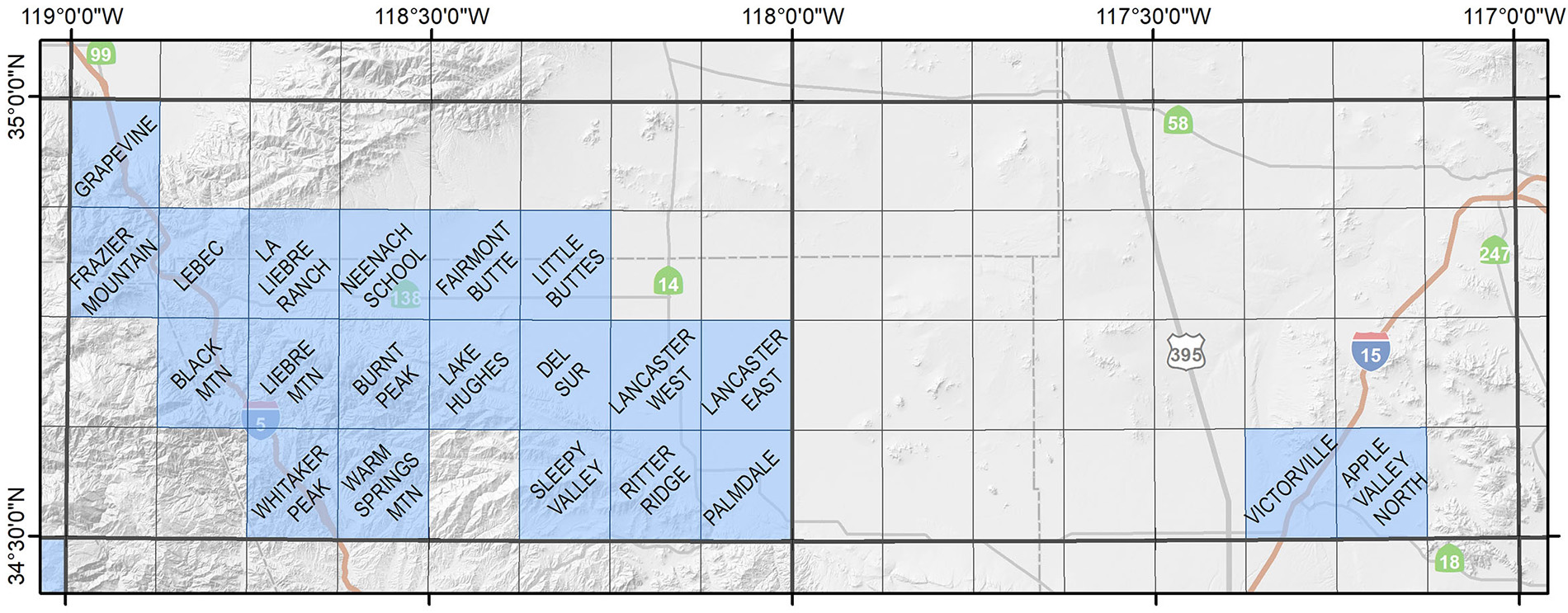
Lancaster-Victorville Region
-
Apple Valley North, 2007 (3.1 MB)
-
Black Mountain, 2021, rev. 2024 (21.6 MB)
-
Burnt Peak, 2022 (19 MB)
-
Del Sur, 2010 (4.6 MB)
-
Fairmont Butte, 2011 (3.9 MB)
-
Frazier Mountain, 2016 (29.7 MB)
-
Grapevine, 2014 (3.5 MB)
-
La Liebre Ranch, 2019 (22 MB)
-
Lake Hughes, 2011 (6 MB)
-
Lancaster East, 2011 (3.5 MB)
-
Lancaster West, 2010 (3.8 MB)
-
Lebec, 2017 (27.6 MB)
-
Liebre Mountain, 2023 (16.6 MB)
-
Little Buttes, 2012 (2.1 MB)
-
Neenach School, 2022 (10 MB)
-
Palmdale, 2013 (4.2 MB)
-
Ritter Ridge, 2009 (8.6 MB)
-
Sleepy Valley, 2012 (4.3 MB)
-
Victorville, 2008 (6.4 MB)
-
Whitaker Peak, 2021 (15 MB)
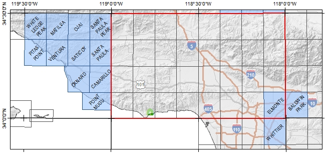
Santa Barbara-Los Angeles Region
Note: The 7.5 minute quadrangles within the Los Angeles 30-by-60 minute quadrangle (outlined in red below) have been updated and are superseded by the Preliminary Geologic Map of the Los Angeles 30-by-60 minute quadrangle (Campbell, et al, 2014).
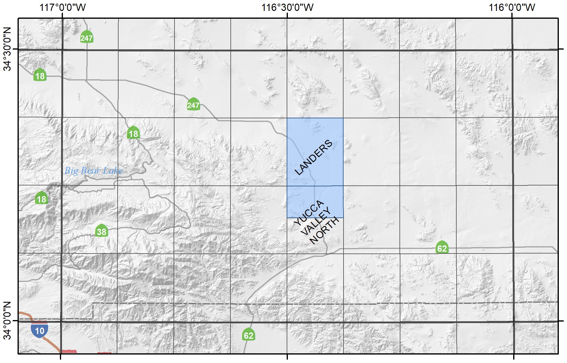
Big Bear Lake Region
Oceanside-San Diego Region
Note: The 7.5 minute quadrangles within the Oceanside 30-by-60 minute quadrangle (outlined in red below) have been updated and are superseded by the Geologic Map of the Oceanside 30-by-60 minute quadrangle (Kennedy and Tan, 2007).
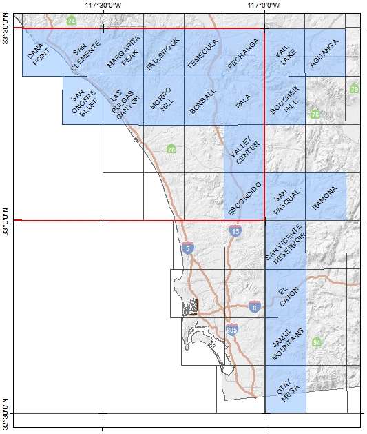
-
Aguanga, 2014 (5.2 MB)
-
Bonsall, 2000 (3.2 MB)
-
Boucher Hill, 2014 (8.9 MB)
-
Dana Point, 1999 (2.3 MB)
-
El Cajon, 2002 (2.2 MB)
-
Escondido, 1999 (2.7 MB)
-
Fallbrook, 2000 (4.7 MB)
-
Jamul Mountains, 2002 (2.1 MB)
-
Las Pulgas Canyon, 2001 (3.7 MB)
-
Margarita Peak, 2001 (5 MB)
-
Morro Hill, 2001 (3 MB)
-
Otay Mesa, 2002 (1.2 MB)
-
Pala, 2000 (4 MB)
-
Pechanga, 2000 (4.2 MB)
-
Ramona, 2006 rev. 2013 (7.0 MB)
-
San Clemente, 1999 (5.2 MB)
-
San Onofre Bluff, 1999 (1.9 MB)
-
San Pasqual, 2007 (2.5 MB)
-
San Vicente Reservoir, 2002 (1.7 MB)
-
Temecula, 2000 (4.8 MB)
-
Vail Lake, 2014 (6.2 MB)
-
Valley Center, 1999 (3.3 MB)
New York Mountains-Ivanpah Region

About the New York Mountains mapping project
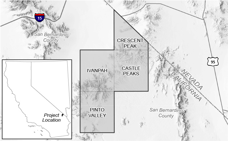
In 2019, the California Geological Survey entered into a cooperative agreement with the United States Geological Survey (USGS) to conduct geologic mapping of the New York Mountains at 1:24,000 scale. This project is supported in part by funding from the USGS Earth Mapping Resource Initiative (Earth MRI), and occurs within the Mountain Pass Rare Earth Element Focus Area.
The field area was selected due to its proximity to the world class, carbonatite-hosted, light rare earth deposit at Mountain Pass. Rare earth elements are among 50 minerals listed as critical by the USGS. Critical minerals are defined as being essential for manufacturing products significantly important to the economy and national security and as having supply chains vulnerable to outside disruption. The Earth MRI Project aims to gather information to identify potential domestic sources of critical minerals.
Web page by:
California Geological Survey - Regional Geologic and Landslide Mapping Program
