 Plate 1A: Geologic Map of the Sierra Nevada is one of several components of the Sierra Nevada Earth Science Atlas.
ON THIS PAGE
Overview
The Sierra Nevada Earth Science Atlas provides the most detailed geologic framework mapping of California’s most iconic landscape to date. This web page hosts the numerous maps, data layers, and an associated report that make up the Atlas. Collectively, these layers and report show and describe the geology of the Sierra Nevada, a prominent mountain range that extends roughly north-south across eastern California and into a small portion of western Nevada, along with adjacent areas. The Atlas is published as Geologic Data Map 9 (GDM 9).
Embedded in the rocks of the Sierra Nevada is a story that spans more than 500 million years. It begins with ocean shelf deposits formed at the margin of the ancient continent that would become North America and volcanic islands and ocean floor deposits formed in the neighboring Panthalassic Ocean. These oceanic rocks would be swept in and added to ancient North America by about 250 million years ago, when subduction and multiple episodes of arc magmatism built a volcanic mountain range rivaling the modern Andes. This story continues through the uplift, erosion, and glaciation that shaped the landscapes, soils, and mineral wealth that define California today.
Please note: Atlas layers will be incrementally added to this site as they become available. In time, this site will also host media content associated with the geology of the Sierra Nevada. Please see Atlas Components section for more information and for downloads of available layers.
About the Publication
The Atlas is a collection of maps, geospatial datasets, and associated text, that presents geological and geophysical information for the Sierra Nevada. It includes:
- Geologic map layers showing the distribution of geologic units and structures (faults) near the Earth’s surface.
- Geophysical layers showing spatial variations in Earth’s gravity and magnetic fields caused by subsurface physical properties of the Earth’s crust such as density and magnetism.
- Economic geology layers showing areas which have significant potential for a given mineral resource, for example, gold or tungsten.
- Neotectonic features layers showing Quaternary faulting, historic earthquake epicenters, late Pleistocene to Holocene volcanic centers, and active hot springs and related features.
- A geochronology data layer showing locations where fossil or isotopic dating methods have been used to determine the age of the unit sampled or other geologic events.
- A report describing and discussing the data layers.
Atlas Components
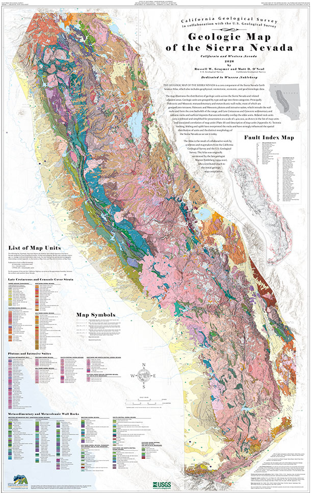
Plate 1A: Geologic Map of the Sierra Nevada
Get the PDF version of Plate 1A
(63 MB - opens new tab)
Summary of Plate 1A
This geologic map shows the different types of rocks found across the Sierra Nevada and surrounding areas. The different geologic units are grouped by their rock type and age into three broad categories:
- Metamorphosed sedimentary and volcanic rocks that mostly formed during the Paleozoic and Mesozoic Eras. Geologic units which share a common tectonic history are grouped as terranes.
- Large bodies of granitic and other plutonic rock that formed during the Paleozoic and Mesozoic Eras. These rocks intruded the older metamorphic rocks and together form the core batholith of the Sierra Nevada.
- Younger sedimentary and volcanic rocks, as well as surficial deposits, that formed during the Late Cretaceous Epoch and Cenozoic Era. These rocks unconformably overlap the older units.
Because this map is shown at a regional scale (1:400,000), related rock types were combined and simplified for presentation. Details about these rock units can be found in Plate 1A’s List of Map Units, the associated Correlation of Map Units (Plate 1B), and the description of map units (Appendix A of the report).
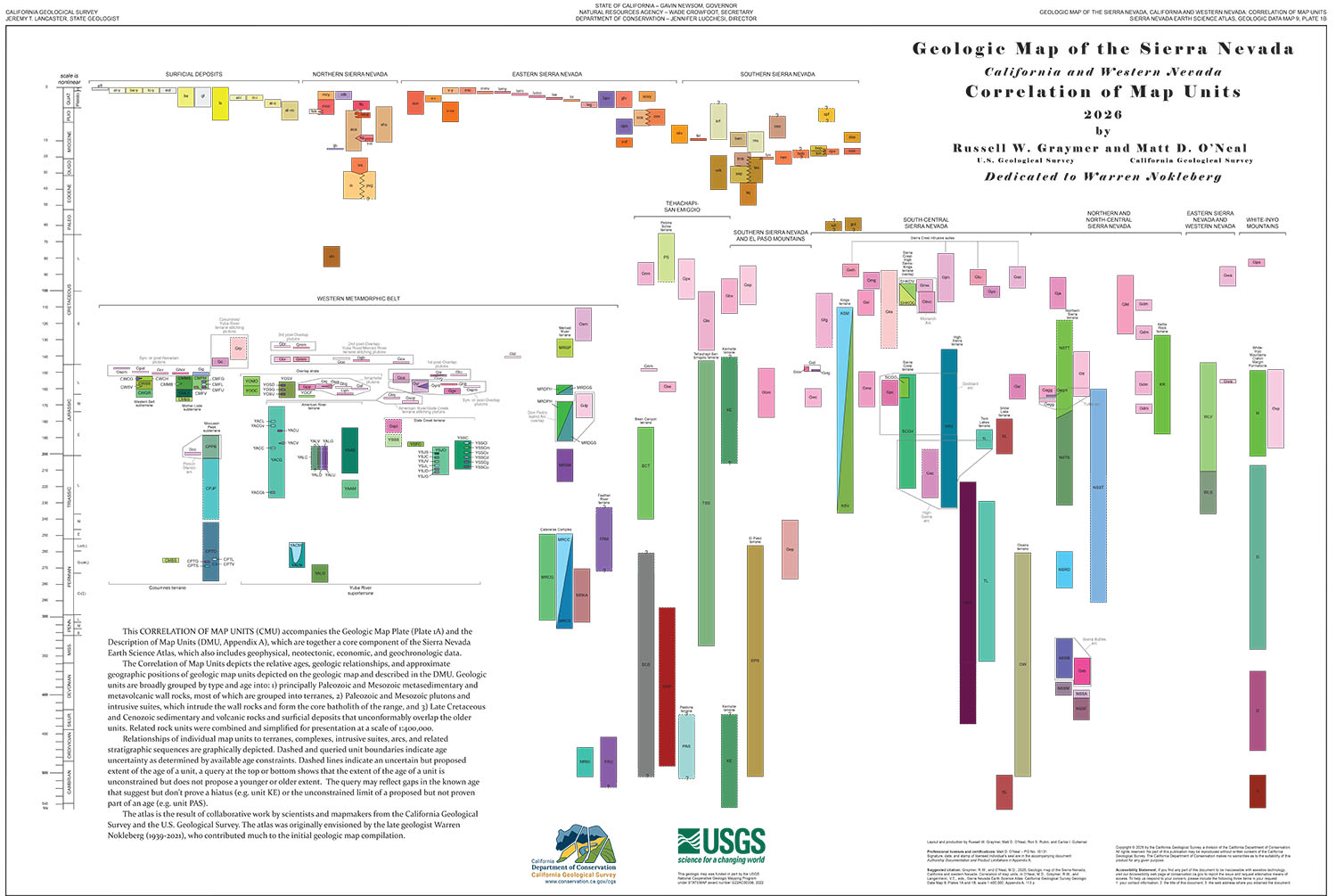
Plate 1B: Correlation of Map Units
Get the PDF version of Plate 1B
(431 KB - opens new tab)
Summary of Plate 1B
This Correlation of Map Units accompanies the Geologic Map (Plate 1A) and shows how the different geologic units on the map relate to one another. It illustrates the relative ages, geologic relationships, and the positions of the rock units with respect to one another.
Data
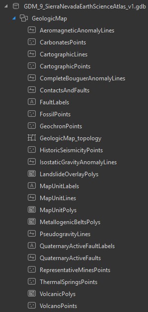
Download GDM 9 Data Package
(38 MB zipped file)
The data package contains the following layers:
- Geologic map
- Mega-landslide deposits
- Geophysical anomalies (gravity and aeromagnetic)
- Geochronology database
- Carbonate bodies (deposits)
- Metallogenic belts and representative mines
- Neotectonic features (Quaternary faults, historic seismicity, recent volcanism, geothermal features)
Credits and Acknowledgments
This Atlas was produced by a team of geoscientists and mapmakers from the California Geological Survey and U.S. Geological Survey. We gratefully acknowledge data and other input provided by the Nevada Bureau of Mines and Geology and many reviewers from academic institutions and state and federal agencies. Please see individual Atlas map plates and associated report chapters for acknowledgement of authors, reviewers, and other contributors specific to that individual Atlas component.
Web page by California Geological Survey
California Regional Geologic and Landslide Mapping Program
