The California State Plane Coordinate System is used for defining and stating positions or locations of points on the surface of the earth within the State of California. It is part of a nationwide system developed in the 1930s and originally was based on the North American Datum 1927 (NAD 27), where the coordinates are based on the foot. The NAD 27 System has since been superseded by the NAD 83 System (based on the meter), but maps in NAD 27 coordinates are still in use.
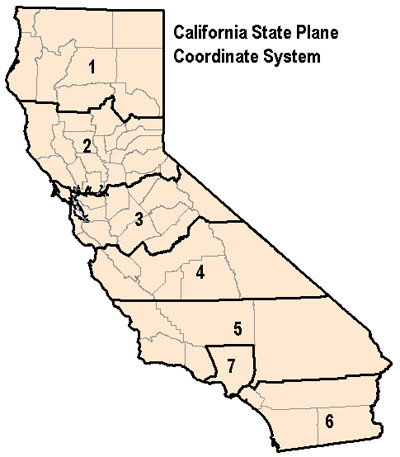 In the State Plane Coordinate System, each state has its own zone(s). The number of zones in a state is determined by the area the state covers, and ranges from one for a small state such as Rhode Island to as many as seven, as we have in California.
Note: Zone 7 applies to NAD 27 only. In NAD 83, Los Angeles County is consolidated into Zone 5.
The projection used for each state is also variable; states that are elongate from east to west, such as New York, use a transverse Mercator projection, while states that are elongate from north to south, such as California, use a Lambert conformal projection (Lambert is the name of the cartographer who designed the projection; the projection itself is a conformal conic projection).
Counties within each Zone
Zone 1 Counties
Del Norte, Humboldt, Siskiyou, Trinity, Shasta, Tehama, Modoc, Lassen, Plumas
Zone 2 Counties
Mendocino, Sonoma, Lake, Napa, Glenn, Colusa, Yolo, Solano, Butte, Sutter, Yuba, Sacramento, Sierra, Nevada, Placer, El Dorado, Amador, Alpine
Zone 3 Counties
Marin, San Francisco, San Mateo, Santa Cruz, Contra Costa, Alameda, Santa Clara, San Joaquin, Stanislaus, Merced, Calaveras, Tuolumne, Mariposa, Madera, Mono
Zone 4 Counties
Monterey, San Benito, Fresno, Kings, Tulare, Inyo
Zone 5 Counties
San Luis Obispo, Santa Barbara, Ventura, Kern, San Bernardino
(Note: in NAD 83, Los Angeles County is consolidated into Zone 5)
Zone 6 Counties
Orange, Riverside, San Diego, Imperial
Zone 7 Counties
Los Angeles
(Note: Zone 7 applies to NAD 27 only. In NAD 83, Los Angeles County is consolidated into Zone 5.)
