 To download a file using Internet Explorer, right-click on the link and select "Save Target As..." (or "Save Link As..." in Netscape). If you would rather view the PDF maps online, double-click on the link, but please be aware that larger files may take a while to open.
Adobe Reader® is required to view the landslide maps or geologic report.

Maps are provided in PDF and PRN (Windows print file) formats. The PDF files have been optimized for viewing on-screen rather than printing, whereas the PRN files will produce higher quality hardcopy maps. Instructions for printing the PRN files are included in the ReadMe file below. A large format plotter (minimum 36" width) is required to print these maps.
GIS data are provided as zipped folders of ESRI coverages and shapefiles in both Teale Albers (NAD27) and UTM Zone 10 (NAD 83) projections.
A complete list of landslide maps and geologic maps is available from the California Geological Survey.
This information is also available for purchase from CGS Publications on CGS CD 2002-09.
DISCLAIMER:
The State of California and the Department of Conservation make no representations or warrantees regarding the accuracy of the data from which these maps were derived. Neither the State nor the Department shall be liable under any circumstances for any direct, indirect, special, incidental or consequential damages with respect to any claim by any user or any third party on account of or arising from the use of these maps.
The identification and location of landslide hazard areas are based on review of limited aerial photographs that are listed on each specific map. In most cases, only two sets of aerial photographs were used to construct the landslide and geomorphic features maps. Due to time constraints all available data were not necessarily reviewed and used in construction of these maps. The quality of data used is varied. The information depicted on the maps has been drawn as accurately as possible at 1:24,000 scale. The maps and reports provided on this web site are subject to change without notice, and the latest available versions will be posted on this web site.
Information on the maps are not sufficient to serve as a substitute for site specific geologic and geotechnical site investigations as required under the Chapters 7.5 and 7.8 of Division 2 of the Public Resources Code.
By DOWNLOADING FILES FROM THE CGS FWGP WEB SITE,
you acknowledge that you have read THE disclaimer
ABOVE AND THAT YOU ACCEPT ITS CONDITIONS
Maps (PDF and Print Files)
| Preview Image |
Description |
Scale |
Download |
|
"ReadMe" File |
Contains printing instructions for PRN print files and helpful information about GIS layers |
N/A |
MATTOLE README FILE
(106 K PDF) |
|
 |
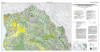
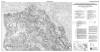
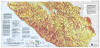
Watershed Mapping Series, Map Set 7, Plate 1, Geologic and Geomorphic Features Related to Landsliding (color), Mattole River Watershed, Humboldt and Mendocino Counties, California
(North, central, and south sheets) |
1:24,000
North: 67"x36"
Central: 72"x36"
South: 56"x36" |
COLOR PDF NORTH
(9.5 MB PDF)
COLOR PDF CENTRAL
(11.1 MB PDF)
COLOR PDF SOUTH
(5.6 MB PDF)
COLOR PRINT FILES
(All Sheets)
(23.7 MB Zipped PRNs) |
|
 |
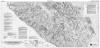
Watershed Mapping Series, Map Set 7, Plate 1, Geologic and Geomorphic Features Related to Landsliding (black-and-white), Mattole River Watershed, Humboldt and Mendocino Counties, California
(North, central, and south sheets) |
1:24,000
North: 67"x36"
Central: 72"x36"
South: 56"x36" |
B&W PDF NORTH
(6.5 MB PDF)
B&W PDF CENTRAL
(7.5 MB PDF)
B&W PDF SOUTH
(3.8 MB PDF)
B&W PRINT FILES
(All Sheets)
(36.4 MB Zipped PRNs) |
|
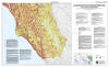 |
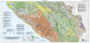
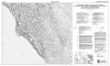
Watershed Mapping Series, Map Set 7, Plate 2, Relative Landslide Potential with Geologic and Geomorphic Features, Mattole River Watershed, Humboldt and Mendocino Counties, California
(North, central, and south sheets) |
1:24,000
North: 67"x36"
Central: 72"x36"
South: 56"x36" |
RLP PDF NORTH
(9.6 MB PDF)
RLP PDF CENTRAL
(11.8 MB PDF)
RLP PDF SOUTH
(6.2 MB PDF)
RLP PRINT FILES
(All Sheets)
(26.9 MB Zipped PRNs) |
GIS Data
| Type |
Description |
Scale |
Download |
|
"ReadMe" File |
Contains helpful information regarding the organization and display of GIS layers
|
N/A |
MATTOLE README FILE
(106 K PDF) |
| Metadata |
Text document describing project background, data processing procedures, data format and attributes for all GIS layers |
N/A |
MATTOLE METADATA
(147 K PDF) |
| Landslide |
active landslides (polygons)
dormant landslides (polygons)
small landslides (points)
narrow landslides (lines)
symbology (lines, used as annotation)
relative landslide potential (polygons) |
1:24,000 |
(These are different formats of the same data package)
Albers (NAD27) Coverages
(52.7 MB Zip)
Albers (NAD27) Shapefiles
(63.0 MB Zip)
UTM (NAD83) Coverages
(32.9 MB Zip)
UTM (NAD83) Shapefiles
(36.3 MB Zip) |
| Geomorphology |
debris slide slopes (polygons)
disrupted ground (polygons)
inner gorges (lines) |
|
Fluvial |
stream features (polygons)
stream features (lines)
stream features (points)
channel classification (Rosgen) (lines)
gullies (lines) |
| Geology |
geologic units (polygons)
contacts and faults (lines)
structures (lines)
strike & dip and other symbols (points) |
1:100,000 |
Publications
| Preview Image |
Description |
Download |
 |
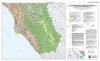
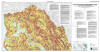
Report on the Geologic and Geomorphic Characteristics of the Mattole River Watershed, California |
MATTOLE Geologic Report
(15.9 MB PDF) |
