To download a file using Internet Explorer, right-click on the link and select "Save Target As..." (or "Save Link As..." in Netscape). If you would rather view the PDF maps online, double-click on the link, but please be aware that larger files may take a while to open.
Adobe Reader® is required to view the landslide maps or geologic report. 
Maps are provided in PDF and PRN (Windows print file) formats. The PDF files have been optimized for viewing on-screen rather than printing, whereas the PRN files will produce higher quality hardcopy maps. Instructions for printing the PRN files are included in the ReadMe file below. A large format plotter (minimum 36" width) is required to print these maps.
GIS data are provided as zipped folders of ESRI coverages and shapefiles in both Teale Albers (NAD27) and UTM Zone 10 (NAD 83) projections.
A complete list of landslide maps and geologic maps is available from the California Geological Survey.
This information is also available for purchase from CGS Publications on CGS CD 2002-08.
Maps (PDF and Print Files)
| Preview Image |
Description |
Scale |
Download |
|
"ReadMe" File |
Contains printing instructions for PRN print files and helpful information about GIS layers |
N/A |
Gualala ReadMe File
(144 K PDF) |
|
 |
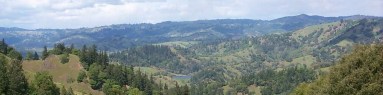
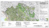
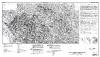
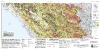
Watershed Mapping Series, Map Set 5, Plate 1, Geologic and Geomorphic Features Related to Landsliding (color), Gualala River Watershed, Sonoma and Mendocino Counties, California
(North, central, and south sheets) |
1:24,000
North: 65"x36"
Central: 74"x36"
South: 60"x36" |
Color PDF North
(11.2 MB PDF)
Color PDF Central
(12.0 MB PDF)
Color PDF South
(8.2 MB PDF)
Color Print Files
(All Sheets)
(17.3 MB Zipped PRNs) |
|
 |
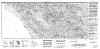
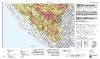
Watershed Mapping Series, Map Set 5, Plate 1, Geologic and Geomorphic Features Related to Landsliding (black-and-white), Gualala River Watershed, Sonoma and Mendocino Counties, California
(North, central, and south sheets) |
1:24,000
North: 65"x36"
Central: 74"x36"
South: 60"x36" |
B&W PDF North
(11.3 MB PDF)
B&W PDF Central
(12.7 MB PDF)
B&W PDF South
(8.7MB PDF)
B&W Print Files
(All Sheets)
(15.1 MB Zipped PRNs) |
|
 |
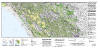
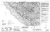
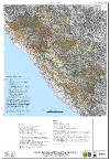
Watershed Mapping Series, Map Set 5, Plate 2, Relative Landslide Potential with Geologic and Geomorphic Features, Gualala River Watershed, Sonoma and Mendocino Counties, California
(North, central, and south sheets) |
1:24,000
North: 65"x36"
Central: 74"x36"
South: 65"x36" |
RLP PDF North
(19.7 MB PDF)
RLP PDF Central
(21.8 MB PDF)
RLP PDF South
(14.0 MB PDF)
RLP Print Files
(All Sheets)
(17.3 MB Zipped PRNs) |
|
 |
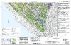
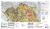
Watershed Mapping Series, Map Set 5, Plate 3, Potential Restoration Sites and Habitat Limiting Factors for the Gualala River Watershed, Sonoma and Mendocino Counties, California |
1:48,000
36"x60" |
Gualala Restoration Sites PDF
(3.9 MB PDF)
Gualala Restoration Sites Print File
(7.8 MB Zipped PRN) |
GIS Data
| Type |
Description |
Scale |
Download |
|
"ReadMe" File |
Contains helpful information regarding the organization and display of GIS layers
|
N/A |
Gualala ReadMe File
(144 K PDF) |
| Metadata |
Text document describing project background, data processing procedures, data format and attributes for all GIS layers |
N/A |
Gualala Metadata
(94 K PDF) |
| Landslide |
active landslides (polygons)
dormant landslides (polygons)
small landslides (points)
narrow landslides (lines)
gullies (lines)
symbology (lines, used as annotation)
relative landslide potential (polygons) |
1:24,000 |
(These are different formats of the same data package)
Albers (NAD27) Coverages
(26.7 MB Zip)
Albers (NAD27) Shapefiles
(33.3 MB Zip)
UTM (NAD83) Coverages
(13.7 MB Zip)
UTM (NAD83) Shapefiles
(14.1 MB Zip) |
| Geomorphology |
debris slide slopes (polygons)
disrupted ground (polygons)
inner gorges (lines) |
|
Fluvial |
stream features (polygons)
stream features (lines)
channel classification (Rosgen) (lines)
alluvial contacts (polygons) |
| Geology |
geologic units (polygons)
contacts and faults (lines) |
1:62,500 |
Publications
| Preview Image |
Description |
Download |
 |
Report on the Geologic and Geomorphic Characteristics of the Gualala River Watershed, California |
Gualala Geologic Report
(16.7 MB PDF) |
