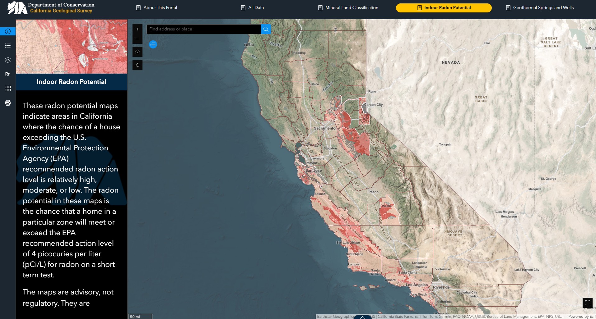
 Web map showing indoor radon potential in California. Explore this map and download related reports and data at our Mineral Resources Data Portal.
About Radon
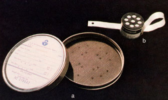 Radon Detectors. This photograph shows two types of inexpensive indoor radon level detectors. Short-term detectors (a) use activated charcoal to adsorb radon from the air and are typically used for tests of 2 to 7 days duration. Long-term alpha-track detectors (b) consist of a piece of special plastic inside a container. They are typically used for tests of 91 days or more. When enough collection time has passed, detectors are sent to special laboratories for analysis.
Radon is a naturally occurring radioactive gas that is invisible and odorless. The gas forms from the radioactive decay of small amounts of uranium and thorium naturally present in rocks and soils. Breathing air with elevated levels of radon gas results in an increased risk of developing lung cancer.
Some amount of radon exists in all rocks and soils, but some rock types, such as black shales and certain igneous rocks, can have uranium and thorium in amounts higher than is typical for the earth’s crust. At these locations, increased amounts of radon will be generated in the subsurface. Because radon is a gas, it can easily move through soil and cracks in building slabs or basement walls and concentrate inside a building. Areas with higher amounts of radon in the underlying rocks and soil are likely to have higher percentages of buildings with indoor radon levels in excess of U.S. Environmental Protection Agency (U.S. EPA) guidelines.
The average concentration of radon in American homes is about 1.3 picocuries per liter and the average concentration in outdoor air is about 0.4 picocuries per liter. The U.S. EPA recommends that individuals avoid long-term exposures to radon concentrations above 4 picocuries per liter. The only way to know what the radon level is in a building or home is to test the air. Fortunately, radon testing is relatively simple and inexpensive.
The California Department of Public Health (CDPH) Radon Program collects radon test data for buildings throughout the state and maintains a radon database, California Radon Measurements by Zip Code. The CDPH uses this database to identify areas with excessive indoor radon levels, areas that may need testing, and to inform the public of the results.
Our Role in Radon Research
The California Geological Survey prepares maps and reports to help the CDPH Radon Program identify areas of radon potential in California. The maps and reports we prepare are advisory, not regulatory. They cannot be used to determine the indoor-air radon level of a particular home or building. The only way to know the radon concentration within a home or building is to actually test for it.
Radon-Related Publications
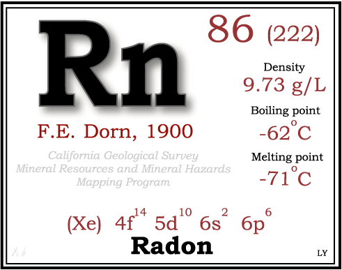 Radon is the only naturally-occurring radioactive gas and is the heaviest of all of the elements that occur as gasses at room temperature and pressure conditions. It is one of a number of intermediate radioactive elements formed during the radioactive decay of uranium-238, uranium-235 or thorium-232 isotopes to form stable, non-radioactive isotopes of lead. Radon-222 is the radon isotope of most concern to public health because it has a much longer half-life (3.8 days) than other radon isotopes (radon-219 at 4 seconds and radon 220 at 55.3 seconds). The longer half-life of radon-222 allows it to migrate farther through the soil, so more radon-222 is usually available to enter buildings than any of the other radon isotopes.
Statewide area of interest
Amador, Calaveras and Tuolumne Counties
- Special Report 242: Radon Potential in Amador, Calaveras and Tuolumne Counties, California (PDF, 8 MB)
- SR 242, Plate 1: Radon Potential Zone Map for Amador, Calaveras and Tuolumne Counties, California (PDF, 15 MB)
El Dorado County
- Special Report 256: Radon Potential in Western El Dorado County, California (2024) and Plate 1: Radon Potential Zone Map for Western El Dorado County, California (both PDF, 38 MB total)
Lake Tahoe Area (eastern El Dorado and Placer counties, and parts of Alpine, Amador, and Nevada counties)
Los Angeles County
- Special Report 182: Radon Potential in Southern Los Angeles County (PDF, 19 MB)
- SR 182, Plate 1: Radon Potential Zone Map for Southern Los Angeles County, California (PDF, 6 MB)
- Special Report 224: Radon Potential in the Palos Verdes Area, California (PDF, 3 MB)
- SR 224, Plate 1: Radon Potential Zone Map for Palos Verdes Area, California (PDF, 2 MB)
Monterey County
- Special Report 201: Radon Potential in Monterey County, California (PDF, 2 MB)
- SR 201, Plate 1: Radon Potential Zone Map for Western Monterey County, California (PDF, 3 MB)
- SR 201, Plate 2: Radon Potential Zone Map for Eastern Monterey County, California (PDF, 2 MB)
Nevada County
- Special Report 258: Radon Potential in Western Nevada County, California (2024) and Plate 1: Radon Potential Zone Map for Western Nevada County, California (both PDF, 53 MB total)
Orange County
Placer County
- Special Report 246: Radon Potential in Western Placer County, California (PDF, 4 MB)
- SR 246, Plate 1: Radon Potential Zone Map for Western Placer County, California (PDF, 5 MB)
San Luis Obispo County
- Special Report 208: Radon Potential in San Luis Obispo County, California (PDF, 2 MB)
- SR 208, Plate 1: Radon Potential Zone Map for Western San Luis Obispo County, California (PDF, 6 MB)
- SR 208, Plate 2: Radon Potential Zone Map for Eastern San Luis Obispo County, California (PDF, 5 MB)
San Mateo County
Santa Barbara and Ventura Counties
Santa Clara County
- Special Report 244: Radon Potential in Western Santa Clara County, California (PDF, 5 MB)
- SR 244, Plate 1: Radon Potential Zone Map for Western Santa Clara County, California (PDF, 8 MB)
Santa Cruz County
Tulare County
- Special Report 238: Radon Potential in Western Tulare County, California (PDF, 9 MB)
- SR 238, Plate 1: Radon Potential Zone Map for Western Tulare County, California (PDF, 2 MB)
Web page by:
California Geological Survey - Mineral Resources Program
