CGS Notes

Off-road vehicle driving through hilly desert.

​CGS Notes (formerly known as DMG Notes) are typically short printer-friendly publications that contain answers to frequently asked questions about California's geology. Most of the Notes are in Adobe Portable Document Format (PDF).

Notes for Students, Educators, and the General Public

Cluster of benitoite crystals.

Note 11. Benitoite: California State Gem

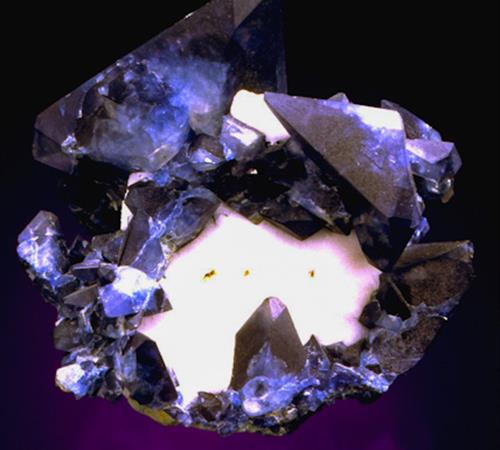
Interesting facts and information about our state gem found only in San Benito County.


California gold coin.

Note 12. Gold: California State Mineral

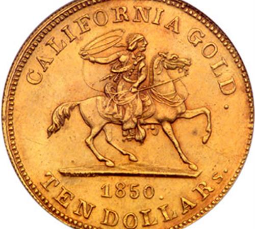
Gleaming information on natural occurrences, mining methods, deposits, production, and other shining facts of California gold.


Sabertoothed Cat fossilized skull.

Note 13. Sabertoothed Cat: California's Official State Fossil

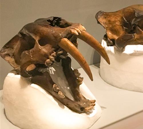
The most famous California Ice Age fossil, Smilodon californicus. What is the connection to the La Brea Tar Pits?


Polished serpentine rock specimen.

Note 14. Serpentine: California State Rock

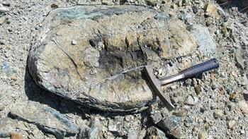
Found in central and northern California in the Coast Ranges, the Klamath Mountains, and the Sierra Nevada foothills, how does its color and texture lead to its unique name?


Geologic map of California.

Note 17. Generalized Geologic Map of California

Gain a general understanding of surface rock distributions throughout California based on their age and origin.


Gold panning in a stream.

Note 24. Hints for Gold Prospectors

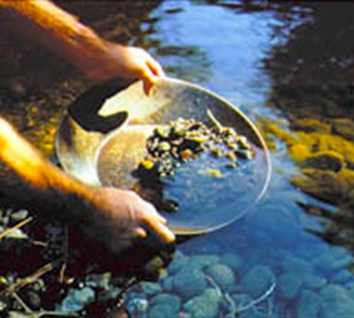
Are you excited about the prospect of finding gold? Here are some things to consider before you head out with your pan in hand.


Earthquake fault on desert surface.

Note 31. Faults and Earthquakes in California

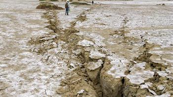
Find important safety information for what to do before, during, and after an earthquake. Also learn about earthquakes in California and how faults are classified.


People busy in the Earthquake Information Center.

Note 32. How Earthquakes Are Measured

Did you know that the original earthquake magnitude scale, the Richter Scale, was developed in 1932 by Cal Tech professor Dr. Charles F. Richter?


Large-scale debris flow covering a road.

Note 33. Hazards From Mudslides... Debris Avalanches and Debris Flows in Hillside and Wildfire Areas

How fast can debris avalanches and debris flows travel? Where do they occur? What triggers them? How can we reduce their hazards? Find out more!


Map of California's geomorphic provinces.

Note 36. California Geomorphic Provinces

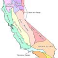
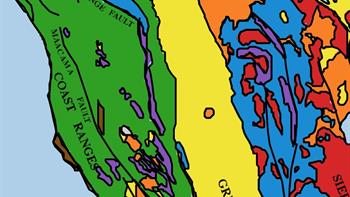
California's geomorphic provinces are naturally defined geologic regions that display unique features based on geology, faults, topographic relief, and climate. These geomorphic provinces are remarkably diverse and provide unique opportunities to learn about Earth's geologic processes and history.


Mammoth skeleton with tusks.

Note 51. Fossils

Although fossils are abundant in some places and absent in others, they are most often found in marine sedimentary rocks such as limestone, sandstone, and shale. Some fossils are found in rocks of nonmarine origin such as sand dunes, volcanic ash, lake sediments, and ice.


Tsunami Hazard Zone sign.

Note 55. Tsunamis

A tsunami is a wave, or series of waves, generated by an earthquake, landslide, volcanic eruption, or even a large meteor hitting the ocean. When one learns about the warning signs of a tsunami, they may save not only their life but also the lives of their family, friends, and others around them.


Profile view of soil layers.

Note 56. Geology, Soils, and Ecology: How geology influences soil development and ecosystems in California

The intent of this note is to highlight the relationship between geology, soil, and ecology by providing selected examples from California’s landscape.


Geologist's rock hammer resting on a rock.

Note 57. Serpentinite and Serpentine in California

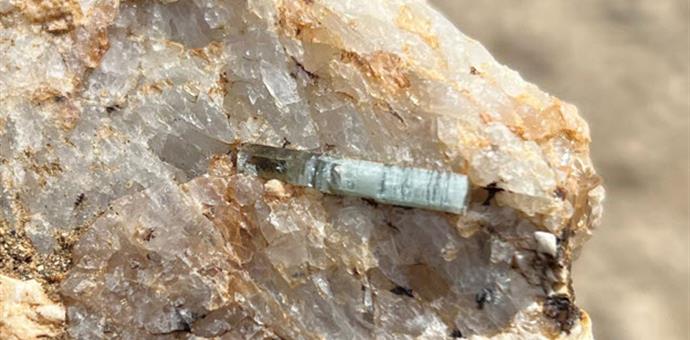
Is it possible for serpentinite to reduce large earthquakes? How does serpentinite create unique vegetative zones? How is it associated with asbestos?


Beryl crystal in matrix.

Note 58. Critical Minerals

What are critical minerals? How do they occur? How are they essential for modern society and national security? Did you know some of these minerals were mined in California before the 1900s?

Notes for Geologists and Other Professionals

Large-scale mining pit.

Note 8. California Non-Fuel Mineral Production - 2001

This is a summary of the longer 2001 report, which you can download from the California’s Non-Fuel Mineral Production page.


Topo map of a watershed.

Note 40. Watersheds Mapping (web page)

Long-range goals of watershed mapping projects include retaining productive forest soils, reducing sedimentation of north coast streams, and protecting fish habitats. Watershed maps also serve as planning guides for timber harvesting and other forest management activities.


Geological map.

Note 41. General Guidelines for Reviewing Geologic Reports (web page)

Guidelines for geologists who review consultants’ geologic reports on behalf of agencies having approval authority over specific developments. These general guidelines are modified from an article titled, "Geologic Review Process" by Hart and Williams (1978).


A shady forest.

Note 45. Guidelines for Geologic Reports for Timber Harvesting Plans

The guidelines may be used by California Professional Geologists, California Certified Engineering Geologists, or California Professional Geotechnical Engineers when preparing engineering geological reports for Timber Harvesting Plans on private, state, and local agency timberlands.


Aerial view of a modern elementary school.

Note 48. Checklist for the Review of Engineering Geology and Seismology Reports for California Public Schools, Hospitals, and Essential Services Buildings

Note 48 is used by the California Geological Survey to review the geology, seismology, and geologic hazards evaluated in reports that are prepared pursuant to the California Building Code for California public schools, hospitals, skilled nursing facilities, and essential services buildings.


Person standing near major earthquake surface rupture.

Note 49. Guidelines for Evaluating the Hazard of Surface Fault Rupture

These guidelines are meant to assist geologists who investigate faults relative to the hazard of surface fault rupture.


Massive landslide of forested terrain above a river valley.

Note 50. Factors Affecting Landslides in Forested Terrain

Factors affecting landslide potential are described according to the geological conditions, drainage characteristics, slope gradient and configuration, vegetation, removal of underlying support, and other conditions specific to each landslide related category.


Mountaintop view of green valley.

Note 52. Guidelines for Preparing Geologic Reports for Regional-Scale Environmental and Resource Management Planning

Geologic studies are used in a variety of regional-scale environmental and resource management planning documents including Program Environmental Impact Reports, General Plans, Safety Elements, Watershed Assessments, Sustained Yield Plans, and Habitat Conservation Plans.


Car crushed by a building.

Note 53. Regulatory Earthquake Hazard Zones: San Francisco Bay Area

The California Geological Survey establishes zones that delineate areas where ground failure is more likely to increase earthquake damage due to liquefaction, landslides, or surface fault rupture. These areas are commonly referred to as “Earthquake Zones of Required Investigation.”


Parking lot severely damaged by liquefaction.

Note 54. Regulatory Earthquake Hazard Zones: Southern California Region

The California Geological Survey establishes zones that delineate areas where ground failure is more likely to increase earthquake damage due to liquefaction, landslides, or surface fault rupture. These areas are commonly referred to as “Earthquake Zones of Required Investigation.”

Retired Notes

A list of Notes that are no longer in circulation.

  • Note 1. [1990]Index to DMG Note Series
  • Note 1. (1970, rev. 1973) Locating a placer mining claim
  • Note 2. How to buy DMG publications
  • Note 2. (1970, rev. 1973) Locating a lode mining claim
  • Note 3. DMG Publications mail order form
  • Note 3. (rev. 1981) Faults and earthquakes
  • Note 4. (1971, rev 1973) Program objectives in the DOC
  • Note 4. CALIFORNIA GEOLOGY Magazine subscription form
  • Note 5. DMG publications of general interest
  • Note 5. (1968, rev. 1970) Serpentine- California state rock
  • Note 6. (1986) Index to geology, Bouguer, and regional geology map sheets
  • Note 6. (1970) Your CDMG mineral exhibit and library at San Francisco
  • Note 7. (1985) DMG photograph archive
  • Note 7. (1968, rev. 1971) Marketing of gold
  • Note 8. (1969, rev. 1971) Lands open to prospecting and location in California
  • Note 8. (1997) California non-fuel mineral production 1996
  • Note 9. CALIFORNIA GEOLOGY Magazine subscription form
  • Note 10. Chrysotile asbestos and serpentinite in California
  • Note 10. (rev. 1982) Some sources of information on California earthquakes and faults
  • Note 11. (rev. 1982) Earthquake article in Mineral Information Service, 1960-1970 and California Geology, 1971-1981
  • Note 12. (1973) Gold refineries
  • Note 12. Gold- California state mineral
  • Note 13. (1973) Possible sources (vendors) of gold nuggets
  • Note 14. (1982) State geological surveys of the United States
  • Note 15. California Well Sample Repository operating procedures and policies
  • Note 15. (1971) Index to the Geologic Atlas of California
  • Note 16. (1986) State Geological Surveys of the United States
  • Note 16. (1973) Smelters in the western United States
  • Note 17. (1991) Simplified geologic map of California
  • Note 17. (1968, rev. 1971, rev. 1982) Map of the California Division of Mines and Geology San Francisco district office and surrounding area
  • Note 18. Some bookdealers handling out-of-print geological publications
  • Note 19. (1973) Mining legal forms
  • Note 20. Information for schools
  • Note 21. (1971) Life through geologic time
  • Note 21A. (1986) Locating a lode mining claim
  • Note 21B. (1986) Locating a placer mining claim
  • Note 22. (1971) Gold: state mineral; Serpentine: state rock
  • Note 23. (rev 1982) How earthquakes are measured
  • Note 24. (1972) Mines - lost and abandoned
  • Note 25. (1972, rev. 1980) Fossils and Paleontology
  • Note 26. (rev. 1988, rev. 1991-1998) The Surface Mining and Reclamation Act of 1975
  • Note 26. Facts about California’s new Strong-Motion Instrumentation Program
  • Note 27A. California laws for mines and mining - manner of locating mining claims, tunnel rights and mill sites
  • Note 27B. California laws for mines and mining - mining partnerships
  • Note 27C. California laws for mines and mining - placer mining water pollution
  • Note 27D. California laws for mines and mining - miscellaneous provisions
  • Note 27. (1972, rev. 1980) How organisms become fossils
  • Note 28. (1971, rev. 1972) California-Nevada caving clubs
  • Note 29. !Mining claims are not for cabin sites!
  • Note 30. (1972, rev. 1976) CDMG: its history and function
  • Note 30. (1991) State Capitol seismic display and transmission system
  • Note 31. (1973) Searching for records of mines and miners
  • Note 31. (1986) Faults and earthquakes in California
  • Note 32. (1986, rev. 1997) How earthquakes and their effects are measured
  • Note 32. Assessment work on mining claims
  • Note 33. (1971) Tips for gold hunters
  • Note 33. (1991) Hazards from “Mudslides"… debris avalanches and debris flows in hillside and wildfire areas
  • Note 34. (1980) Meteorites
  • Note 35. (1979) Geomorphic provinces and some principal faults of California
  • Note 36. (1980) How to order CDMG Publications
  • Note 37. (1973) Guidelines to geologic/seismic reports
  • Note 38. (1980) Saber-toothed cat: Official state fossil
  • Note 39. (1982) CDMG photograph files
  • Note 40. (1982) Distribution of mineral resources in California
  • Note 41. (rev. 1982) Guidelines for California Geology articles
  • Note 42. Guidelines to geologic/seismic reports (see Note 41, Note 45, Note 48, Note 49, Note 52, Special Publication 42, and/or Special Publication 117A)
  • Note 42. Resume of CDMG activities
  • Note 43. (1975) Recommended guidelines determining maximum credible and maximum probable earthquakes (see OFR 96-08 and SP 117)
  • Note 44. (1999) Guidelines for preparing engineering geologic reports
  • Note 45. Recommended guidelines for preparing mine reclamation plans
  • Note 46. (1982) Guidelines for geologic/seismic considerations in environmental impact reports
  • Note 47. (1986) Guidelines for geologic reports on offshore operations and facilities
  • Note 50. (rev. 1980) Surface Mining and Reclamation Act of 1975
  • Note 51. Index to CDMG Note series
  • Note 52. Classification of landslides
  • Note 53. California well sample repository- operating procedures and policies
  • Note 54. Guidelines for geologic review of timber harvesting plans
  • Note 55. California laws for mines and mining from California Public Resources Code
  • Note 55A. Manner of locating mining claims, tunnel rights, and mill sites
  • Note 55B. Mining partnerships
  • Note 55C. Placer mining water pollution
  • Note 55D. Miscellaneous provisions
  • Note 56. CDMG Open-file reports, 1977-1982

‭(Hidden)‬ Custom CSS