Introduction by former California State Geologist, Dr. John Parrish
Introduction
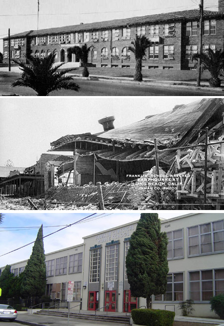
Pictures of the Franklin Junior High School in Long Beach, before the earthquake (top), after the earthquake (middle) and what it looks like today (bottom).
MARCH 10th – To American history buffs, this is the date in 1681 when William Penn was given the colony of Pennsylvania by King Charles II of England – but to Californians, and especially to those who live in the greater Long Beach area of southern California, March 10th is chiseled in history as the date of the Great 1933 Long Beach Earthquake.
In the early evening hours on March 10, 1933, the treacherous Newport-Inglewood fault ruptured, jolting the local citizenry just as the evening meals were being prepared. The Magnitude 6.4 earthquake caused extensive damage (approximately $50 million in 1933 dollars) throughout the City of Long Beach and surrounding communities. Damage was most significant to poorly designed and unreinforced brick structures. Sadly, the earthquake caused 120 fatalities.
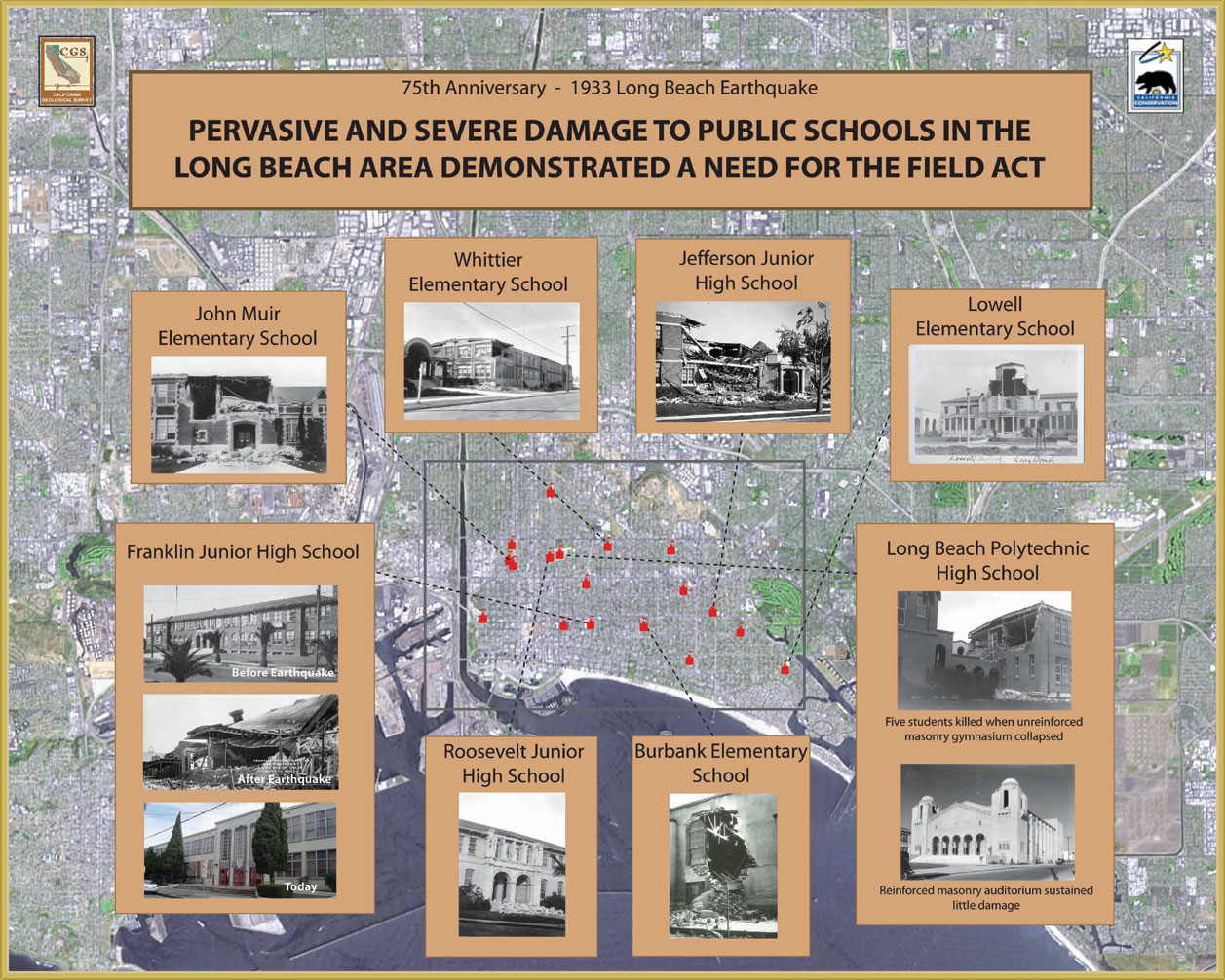
Within a few seconds, 120 schools in and around the Long Beach area were damaged, of which 70 were destroyed. Experts concluded that if children and their teachers were in school at the time of the earthquake, casualties would have been in the thousands.
Just one month after the earthquake, the California State Legislature enacted the Field Act when it was determined that loose subsoil, shoddy workmanship, and substandard materials all contributed to the failure of the school structures. The Field Act authorizes the Division of the State Architect (DSA) to review and approve all public school plans and specifications and to furnish general supervision of the construction work. The California Geological Survey assists the DSA by reviewing geologic hazards affecting schools subject to the Field Act.
Since the enforcement of the Field Act, no school has collapsed because of a seismic event, and there has been no loss of life.
We at CGS hope that this website will help you gain a perspective about the impact of this earthquake...from the horrific damage it caused to how the California government acted to help protect future generations of its citizens.
Earthquake Facts and Figures
When: 5:54 p.m. March 10, 1933.
Where: Epicenter was 3 miles south of Huntington Beach, about 8 miles deep.
Source: Newport-Inglewood Fault. The fault extends on land for 46 miles from Culver City to Newport Beach, where it runs into the Pacific Ocean. It is part of a fault system that is connected to the Rose Canyon Fault, which comes on shore to the south near San Diego. In the Los Angeles area, the surface expression of the Newport-Inglewood Fault is accentuated by a line of hills extending from Signal Hill to Culver City. The Newport-Inglewood is a right-lateral strike-slip fault with a slip rate of about 0.02 inches per year. It is thought to be capable of producing an earthquake as large as M7.4.
Magnitude: The 1933 earthquake was a magnitude 6.4 and it is estimated the fault ruptured for about nine miles in the subsurface (there was no surface fault rupture). The ground shaking lasted about 10 seconds. The maximum recorded ground acceleration was 22 percent of the force of gravity. Note: Long Beach was the first earthquake recorded by just-developed strong motion instruments (“accelerographs”). Acceleration recordings were off the monitor’s scale on some instruments.
Casualties: 120 deaths, including 52 in Long Beach and 17 in Compton. An estimated two-thirds of these occurred as people ran out of buildings and were hit by falling debris. There were also more than 500 injuries reported in Long Beach alone.
Damage: About $50 million, in 1933 dollars. Significant damage occurred in Long Beach, Huntington Park, Compton and other areas where there was a combination of poor construction practices and unfavorable geological conditions causing increased ground shaking and liquefaction. Brick-and-mortar construction fared particularly poorly. Seventy schools were destroyed and 120 damaged, which represents about 75% of the schools in the area. Broken gas lines caused fires in Long Beach. Several areas were without water due to broken pipes. Oil derricks were shaken out of the ground in Huntington Beach. The earthquake impacted an estimated 75,000 square miles and was felt as far away as the San Joaquin Valley, the Owens Valley and northern Baja California.
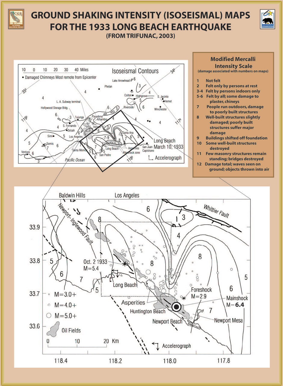
Ground shaking intensity (isoseismal) maps for the 1933 Long Beach earthquake
Click on the image for a larger view.
Aftermath and The Field Act
As a result of all the damage to school buildings, the California State Legislature passed the Field Act just a month after the earthquake. The Field Act requires that the building designs be based on high-level building standards adopted by the state and that plans and specifications be prepared by competent designers qualified by state registration. The quality of construction was to be enforced through independent plan review and independent inspection. Finally, the design professionals, independent inspector and the contractor must verify under penalty of perjury that the building was constructed according to the approved plans. The Field Act, as adopted, applied only to new construction; not to existing pre-1933 school buildings. Legislation to cover the criteria for continued use or abandonment of these pre-1933 school buildings was enacted under the Garrison Act of 1939. As of 1974, all pre-Field Act schools in the Los Angeles area have been retrofitted.
Pervasive and severe damage to public schools in the Long Beach Area demonstrated a need for the Field Act
Click on the image for a larger view.
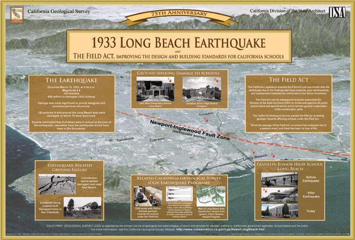
75th anniversary poster commemorating the 1933 Long Beach earthquake and The Field Act
The following image is available for download as a high resolution, 5.3 megabyte PDF document. Click on the image to download the PDF.
Photos from Long Beach Historical Society and Jim Laub, Long Beach Unified School District
Web page by:
California Geological Survey - Seismic Hazards Program
