The Seismic Hazards Mapping Act (SHMA) of 1990 (Public Resources Code, Chapter 7.8, Section 2690-2699.6) directs the Department of Conservation, California Geological Survey to identify and map areas prone to earthquake hazards of liquefaction, earthquake-induced landslides and amplified ground shaking. The purpose of the SHMA is to reduce the threat to public safety and to minimize the loss of life and property by identifying and mitigating these seismic hazards. The SHMA was passed by the legislature following the 1989 Loma Prieta earthquake.
The SHMA requires the State Geologist to establish regulatory zones (Zones of Required Investigation) and to issue appropriate maps (Seismic Hazard Zone maps). These maps are distributed to all affected cities, counties, and state agencies for their use in planning and controlling construction and development. Single family frame dwellings up to two stories not part of a development of four or more units are exempt from the state requirements. However, local agencies can be more restrictive than state law requires.
What is a Seismic Hazard Zone?
A Seismic Hazard Zone is a regulatory zone that encompasses areas prone to liquefaction (failure of water-saturated soil) and earthquake-induced landslides.
Learn how and why the California Geological Survey maps areas susceptible to earthquake hazards and helps mitigate these risks by providing helpful scientific information.
-
Liquefaction occurs when loose, water-saturated sediments lose strength and fail during strong ground shaking. Liquefaction is defined as the transformation of granular material from a solid state into a liquefied state as a consequence of increased pore-water pressure. The process of zoning for liquefaction combines Quaternary geologic mapping, historical ground-water information and subsurface geotechnical data. Required Investigation boundaries are based on the presence of shallow historic groundwater (< 40 feet depth) in uncompacted sands and silts deposited during the last 15,000 years and sufficiently strong levels of earthquake shaking expected during the next 50 years.
-
Landslides tend to occur in weak soil and rock on sloping terrain. The landslide hazard Zone of Required Investigation boundaries generally indicate steep hillslopes composed of weak materials that may fail when shaken by an earthquake. The process for zoning earthquake-induced landslides incorporates expected future earthquake shaking, existing landslide features, slope gradient and strength of hillslope materials.
It must be noted that a single earthquake capable of causing liquefaction or triggering landslide failure will not uniformly impact the entire zoned area. However, the inclusion of mitigation measures throughout the zoned area will help limit the devastating impacts from an earthquake in the higher risk areas.
What does it mean to be located within a Seismic Hazard Zone?
It means that the state has determined that there is likely that weak soil and/or rock may be present beneath the property. If present, these weak materials can fail during an earthquake and, unless proper precautions are taken during grading and construction, can cause damage to structures. If a property is undeveloped, a site-specific investigation by a licensed engineering geologist and/or civil engineer may be required before the parcel can be subdivided or before most structures can be permitted. If the property lies within a mapped Seismic Hazard Zone, that fact must be disclosed by the seller to prospective buyers.
Seismic Hazard Zone Disclosure Requirements
Effective June 1, 1998 (as amended June 9, 1998), the Natural Hazards Disclosure Act requires that sellers of real property and their agents provide prospective buyers with a "Natural Hazard Disclosure Statement" when the property being sold lies within one or more state-mapped hazard areas. If a property is located in a Seismic Hazard Zone as shown on a map issued by the State Geologist, the seller or the seller's agent must disclose this fact to a potential buyers. The law specifies two ways in which this disclosure can be made. One is to use the new Natural Hazards Disclosure Statement as provided in Section 1102.6c of the California Civil Code. The other way is to use the Local Option Real Estate Disclosure Statement as provided in Section 1102.6a of the California Civil Code. The Local Option Real Estate Disclosure Statement can be substituted for the Natural Hazards Disclosure Statement only if the Local Option Statement contains substantially the same information and substantially the same warning as does the Natural Hazards Disclosure Statement.
In addition to Seismic Hazard Zones, information shown on official maps of Earthquake Fault Zones (pursuant to the Alquist-Priolo Act) and other state and federal maps of natural hazards also must be disclosed.
How can I find out if a property is located in a Seismic Hazard Zone?
Official Maps of Seismic Hazard Zones are issued periodically by the California Geological Survey in compliance with the Seismic Hazard Mapping Act. The easiest way is to find out if a property is located in a Seismic Hazard Zone is to use the
California Earthquake Hazards Zone Application or search
our collection of online maps. You can also visit one of the
California Geological Survey offices (call ahead), or your city or county office. Your county assessor, recorder, and planning agency are all required to post notices that advise the public of the availability and location of Seismic Hazard Zone Maps affecting that county (Public Resources Code 2696c). Consult the appropriate local agency if you are uncertain whether a property lies within a Seismic Hazard Zone.
Seismic Hazard Zone Maps
Staff geologists in the Seismic Hazards Program (Program) gather existing geological, geophysical and geotechnical data from numerous sources to compile Seismic Hazard Zone Maps. They integrate and interpret these data regionally in order to evaluate the severity of the seismic hazards and designate Zones of Required Investigation for areas prone to liquefaction and earthquake-induced landslides. Cities and counties are then required to use the Seismic Hazard Zone Maps in their land use planning and building permit processes.
Seismic Hazard Zone Maps are released to the public in two forms - Preliminary and Official. A Preliminary map release provides a 90-day public comment period for technical review and comment. Once the public review period has ended, the Department of Conservation then also has 90 days to revise the maps, as appropriate, and will then release an Official map to affected cities, counties and state agencies approximately six months after the Preliminary release. The CGS will ultimately map all of California’s principal urban and major growth areas. Each map covers an area of approximately 60 square miles and utilizes a scale of 1-inch = 2,000 feet.
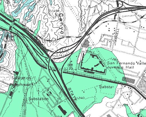
Portion of a Seismic Hazard Zone Map
|
Zones of Required Investigation for Earthquake-Induced Landslides (shown as blue on Maps)
|
|
|
Zones of Required Investigation for Liquefaction (shown as green on Maps)
|
How can I be certain that the map I have is an Official Map of Seismic Hazard Zones?
The
California Earthquake Hazards Zone Application is the best official resource for locating Seismic Hazard Zones; however, if you have a paper or PDF version of a Seismic Hazard Zone Map, only official maps will have the following text displayed prominently:
[NAME] QUADRANGLE
SEISMIC HAZARD ZONES
Delineated in compliance with Chapter 7.8
Division 2 of the California Public Resources Code
(Seismic Hazards Mapping Act)
OFFICIAL MAP [or] REVISED OFFICIAL MAP
Released: [Date]
[Signature]
STATE GEOLOGIST
Site Investigations and Geotechnical Reports
The SHMA requires site-specific geotechnical investigations be conducted identifying the hazard and formulating mitigation measures prior to permitting most developments designed for human occupancy within the Zones of Required Investigation. Before a development permit can be issued or a subdivision approved, cities and counties must require a site-specific investigation to determine whether a significant hazard exists at the site and, if so, recommending measures to reduce the risk to an acceptable level. The investigation must be performed by state-licensed engineering geologists and/or civil engineers.
Seismic Hazard Zone Maps identify where a site investigation is required, and the site investigation determines whether structural design or modification of the project site is necessary to ensure safer development. A copy of each approved geotechnical report including the mitigation measures is required to be submitted to the Program within 30 days of approval of the report. A Certified Engineering Geologist or Registered Civil Engineer with competence in the field of seismic hazard evaluation is required to prepare, review and approve the geotechnical report. The SHMA requires peer review and this individual may be either local agency staff or a retained consultant.
Upload Seismic Hazard Geological Investigation Documents
It must be noted that the Department of Conservation does not have authority to approve or disapprove geotechnical reports; rather the data are utilized for future updates as well as to monitor the effectiveness of the SHMA. In addition, cities and counties are to incorporate the Seismic Hazard Zone Maps into their Safety Elements. Both the Act and the Natural Hazard Disclosure Statement also require sellers of real property to disclose to buyers if property is in a seismic hazard Zone of Required Investigation.
Additional Information
Visit the California Seismic Hazards Program website, visit the
CGS Information Warehouse to view and download Seismic Hazard Zone Maps and Evaluation Reports, or download Special Publications
117 and
118 or contact us at
shmp@conservation.ca.gov or SHMP, 715 P Street MS 1901, Sacramento, CA 95814
Related Links
Web page by:
California Geological Survey - Seismic Hazards Program
