California Geological Survey Geologic Special Report 189
U.S. Geological Survey Open File Report 2004-1304
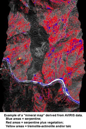 The California Geological Survey (CGS), in a joint project with the United States Geological Survey (USGS), published a preliminary report describing a pilot project to test remote sensing technology in the mapping of rocks that may contain naturally occurring asbestos. Airborne Visible/InfraRed Imaging Spectrometer (AVIRIS) data were collected in ~3-km-wide swaths over selected areas in El Dorado and Plumas counties that contain serpentinite and ultramafic rocks as part an experiment to determine if potentially asbestos-bearing rocks could be identified spectrally. Mineral maps created from the AVIRIS data were used successfully to delineate exposures of serpentine and tremolite-actinolite/talc in areas with up to 70% vegetation cover in some cases. In other cases, the density of vegetation is so high that it prevented spectral identification by AVIRIS of minerals in those areas, thus there may be more serpentine and tremolite-actinolite/talc present than is shown on the mineral maps. It is also important to note that not all tremolite-actinolite is fibrous and that just because tremolite-actinolite was mapped does not necessarily mean it is tremolite-asbestos or actinolite-asbestos. Finally, it is difficult to spectrally distinguish tremolite-actinolite from talc using AVIRIS. Serpentine has been detected outside of known serpentinite outcrop areas, mostly as aggregate that covers dirt roads. Four flight lines of AVIRIS data were analyzed over areas selected to show trends in degree of surface exposure as a function of elevation and vegetation cover. Field checking has verified the accuracy of the mineral maps at 25 accessible locations. Eleven additional flight lines remain to be analyzed and field checked pending future funding. AVIRIS mineral mapping has shown promise as a complement to field mapping, but cannot replace it. Because AVIRIS is a remote-sensing technology, the presence of serpentine or tremolite/actinolite would have to be verified in the field by direct observation and by appropriate sampling and laboratory analysis if needed. No conclusions regarding the presence or absence of asbestos minerals in the identified areas are possible from the AVIRIS data alone at this time. Identification of asbestos minerals in the identified areas would require appropriate sampling and laboratory analysis of the materials in those areas.
Copies of the report are available for downloading below.
