Reproduced from the April 2006 special edition of CALIFORNIA GEOLOGY™ magazine (Special Publication 125).
Updated and edited April 2023 by Jeremy Altringer and Robert Wurgler
Download the publication as it originally appeared in CALIFORNIA GEOLOGY™ magazine
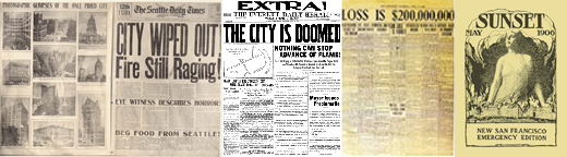
On April 18, 1906 San Francisco was near totally destroyed by a great earthquake and an ensuing devastating fire. What occurred during the "Great San Francisco Earthquake and Fire" was beyond the experience or imagination of the people living in 1906. San Francisco and the surrounding area had experienced large earthquakes in the years 1838, 1865, and 1868, but those events were nothing like the destructive power of the magnitude 7.9 earthquake that ruptured nearly 270 miles of the then little understood San Andreas fault.
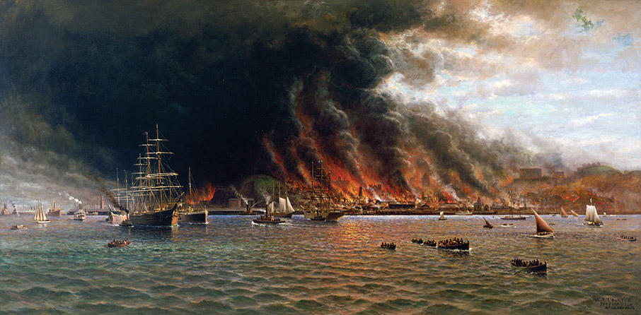 Oil painting titled San Francisco Fire, 1906 by W.A. Coulter. The artist's vivid portrayal of the fire that burned for three days, destroying thousands of buildings, was first sketched during repeated trips on the Sausalito Ferry during the evacuation of the city. Coulter later completed the painting on a 5- by 10-foot window shade he salvaged during the fire. Image of painting courtesy of the W.A. Coulter Retrospective Exhibition Committee of the Paul and Linda Kahn Foundation.
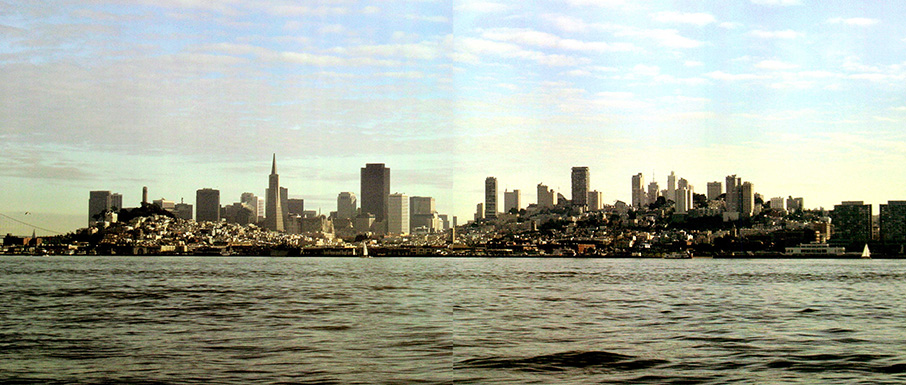 This 2006 photograph of San Francisco incorporates the same view that Coulter captured in his painting 100 years earlier. The Ferry Building, Telegraph Hill, Fairmont Hotel, and Nob Hill are among landmarks that are discernable in both images. Source: Photo by Vladimir Graizer, California Geological Survey.
Introduction
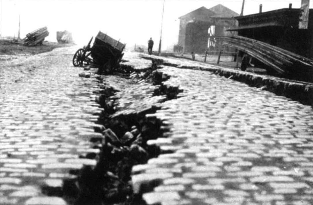 A large crack in cobblestone pavement. Source: The Museum of the City of San Francisco
CALIFORNIA GEOLOGY™ magazine and its predecessor, the MINERAL INFORMATION SERVICE, were in print from 1948 to 2001 providing information on the latest academic and applied geologic studies, written with the public in mind. Many of the articles in these publications were tied to events affecting California and its residents. Whether it was mining and mineral hazards, or landslides and earthquakes, the readers knew they were getting pertinent facts that might help them make decisions about daily living in California.
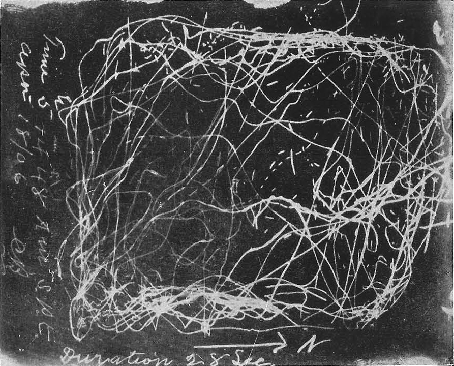 Seismogram of the 1906 San Francisco earthquake, recorded at the Chabot Observatory in Oakland. Source: S.A. Moore, "The San Francisco Catastrophe"
Had CALIFORNIA GEOLOGY™ been published back in 1906, it is likely that several issues would have been dedicated to the "Great San Francisco Earthquake and Fire." The truth of the matter is that, although the California Geological Survey existed as the State Mining Bureau and was headquartered in the Ferry Building in the city of San Francisco, the focus of the organization was on minerals and mining activities, not seismic activity. California did not routinely map faults and study earthquakes until after the magnitude 7.7 Arvin-Tehachapi earthquake of 1952.
Today, the California Geological Survey is one of the premiere geologic and seismologic organizations in the world. CGS is mandated by state legislation to provide maps and information vital to help protect the public from earthquake hazards. A comprehensive earthquake program has set the standard in seismic hazard zonation, earthquake strong-motion instrument monitoring, and probabilistic earthquake-shaking modeling. Other government agencies enlist the expertise of survey geologists and seismologists to review technical documents for the siting and construction of new schools and hospitals. The survey also advises and participates with other state and local agencies in emergency response following damaging earthquakes, landslides, and tsunamis.
Every anniversary of the 1906 earthquake is an opportunity to reflect on how far science has advanced in its understanding of earthquakes and how much more there is to learn.
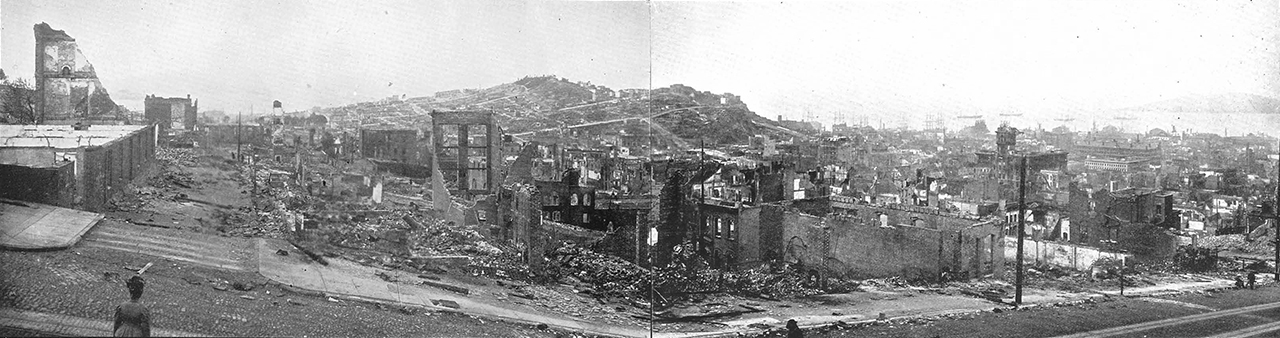
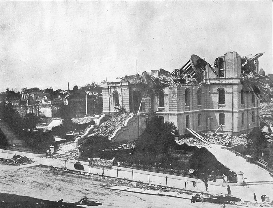
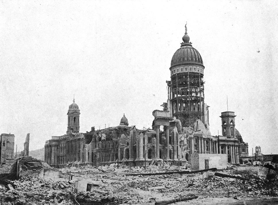 San Francisco City Hall in ruins. Source: Museum of the City of San Francisco
Historical Accounts
CALIFORNIA GEOLOGY™ magazine was privileged to have several first-hand accounts of the "Great San Francisco Earthquake." The first account included here is that of Mrs. Eleanor Watkins, the wife of a San Francisco surgeon. The following excerpts are her observations written during the days following the earthquake in a letter to relatives in Virginia describing San Francisco's plight.
San Francisco, April 1906
[After the earthquake]…the streets were instantly full of throngs of people, many in their night clothes. The sun was rising red behind a queer brown cloud. I said, "That is the typical sun of earthquakes and cyclones that we read about."
In a few moments I noticed five billowy columns rising in this queer cloud in different directions, and I realized it was smoke. The great fire had begun, though no one realized what it would be….
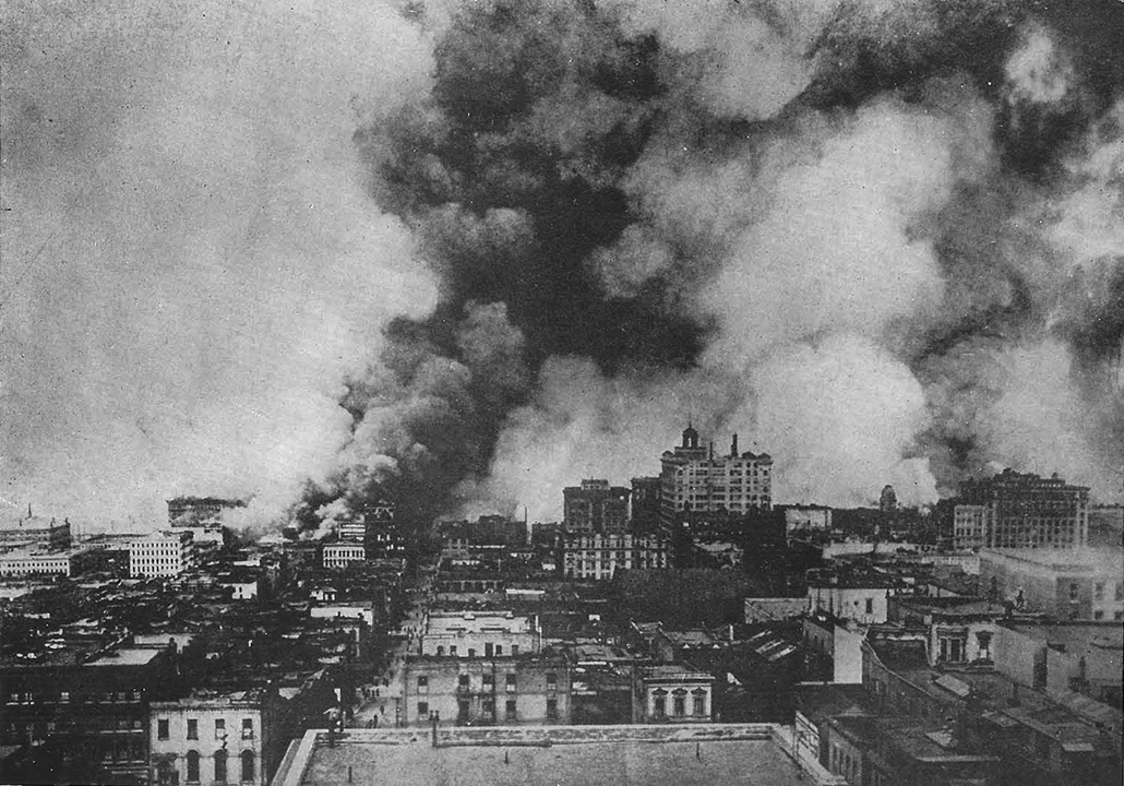 Fire on Wednesday morning making fearful headway. Source: S.A. Moore, "The San Francisco Catastrophe"
We had heard people calling, "Look at the Power House!" "Look at the City Hall! " The Power House was within a square of us—one of three in the city. Its tower had fallen and mashed in the roof.
The City Hall was straight down Hyde Street, about six squares from us. It was granite, and occupied a square—a magnificent building. The dome was standing (this was the Hall of records which fortunately contained the City's most valuable records and title papers), but the rest was a pile of ruins.
 Upheaval of earth where it was perfectly level before. Source: S.A. Moore, "The San Francisco Catastrophe"
The effects of the earthquake were in spots—not universal. We saw whole fronts of office buildings and of assembly halls fallen outward. Sometimes the asphalt pavement had heaved up in a hillock, where gas had exploded.
We heard that the old Valencia Street Hotel, in the Mission, had sunk 20 feet, collapsed and killed 50 people. This was true. It had the severest shock in San Francisco. The handsome residence district on Pacific Heights, overlooking the ocean, was scarcely injured, except fallen chimneys….
As we crossed Union Square to the Saint Francis Hotel, the crowd came in surges and Union Square was full of poor people, who had fled from the fire south of Market Street, where the poorest people lived. Around them were piled trunks and bundles, parrots and babies. A woman had fainted at the corner and was lying on the grass in the crowd.
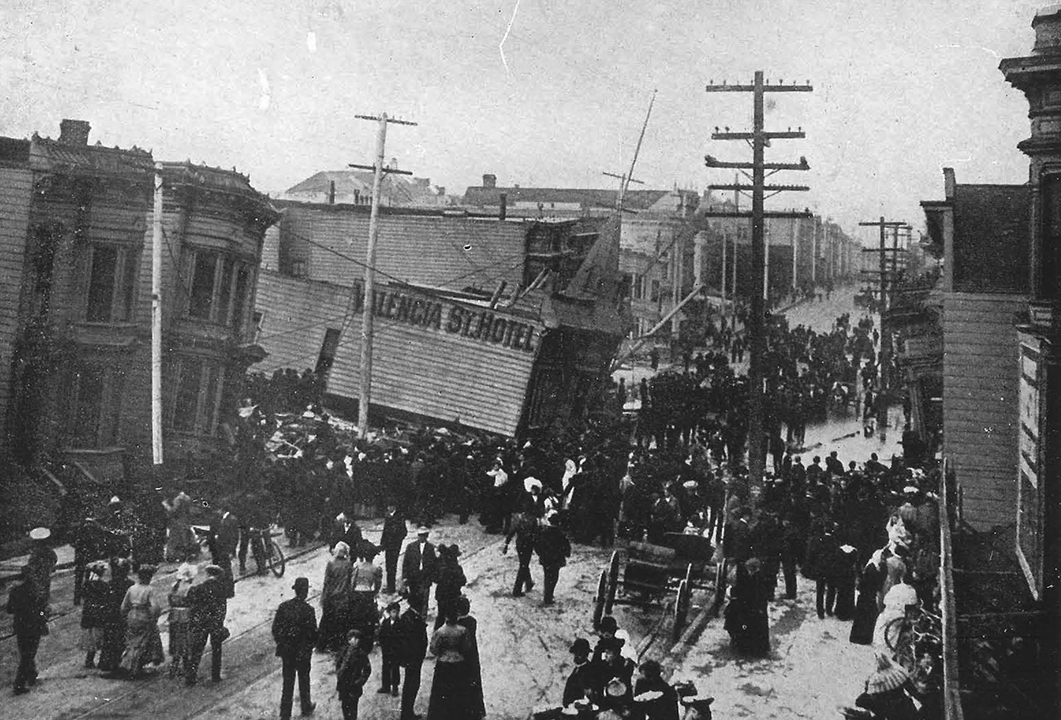 Valencia Street Hotel horror where forty-two people were killed—consumed by fire a few hours later. Source: S.A. Moore, "The San Francisco Catastrophe"
Strange to say the Statue of Victory, which is perched on one toe at the top of a column one hundred feet high in Union Square was uninjured. We went into the Saint Francis to find its lobby crowded with dress suit cases and tourists, who were begging for carriages or wagons, to take them to the ferry. The ornate ceiling, the frescoes and carvings were broken at every corner, and the waiters too excited to bring us anything but coffee. We collected rolls, sugar, knives and forks and spoons from other uncleared tables. The coffee braced us up, for I was on the verge of tears over the homeless people in Union Square, little thinking that I should soon be one of them.
We walked down to Market Street, the chief business street of the city. On Mission Street, next south of Market, about six squares were burning. Let me draw a rough sketch of the city, of course inaccurate. It is, you know, at the end of a peninsula. Market Street divides the city diagonally in two. South of it were the residences of the poorer people and wholesale houses, and at the end of it was the ferry building. It was the main business street, and held most of the skyscrapers, the newspaper buildings, office building, large hotels, government buildings, and it began the business section which extended further north, along Kearney, Montgomery, Grant Avenue etc., holding the great shops, importing houses, etc. South of it were the Post Office and the Mint, almost the only large buildings to be saved from the fire, and they only by marvelously heroic fighting.
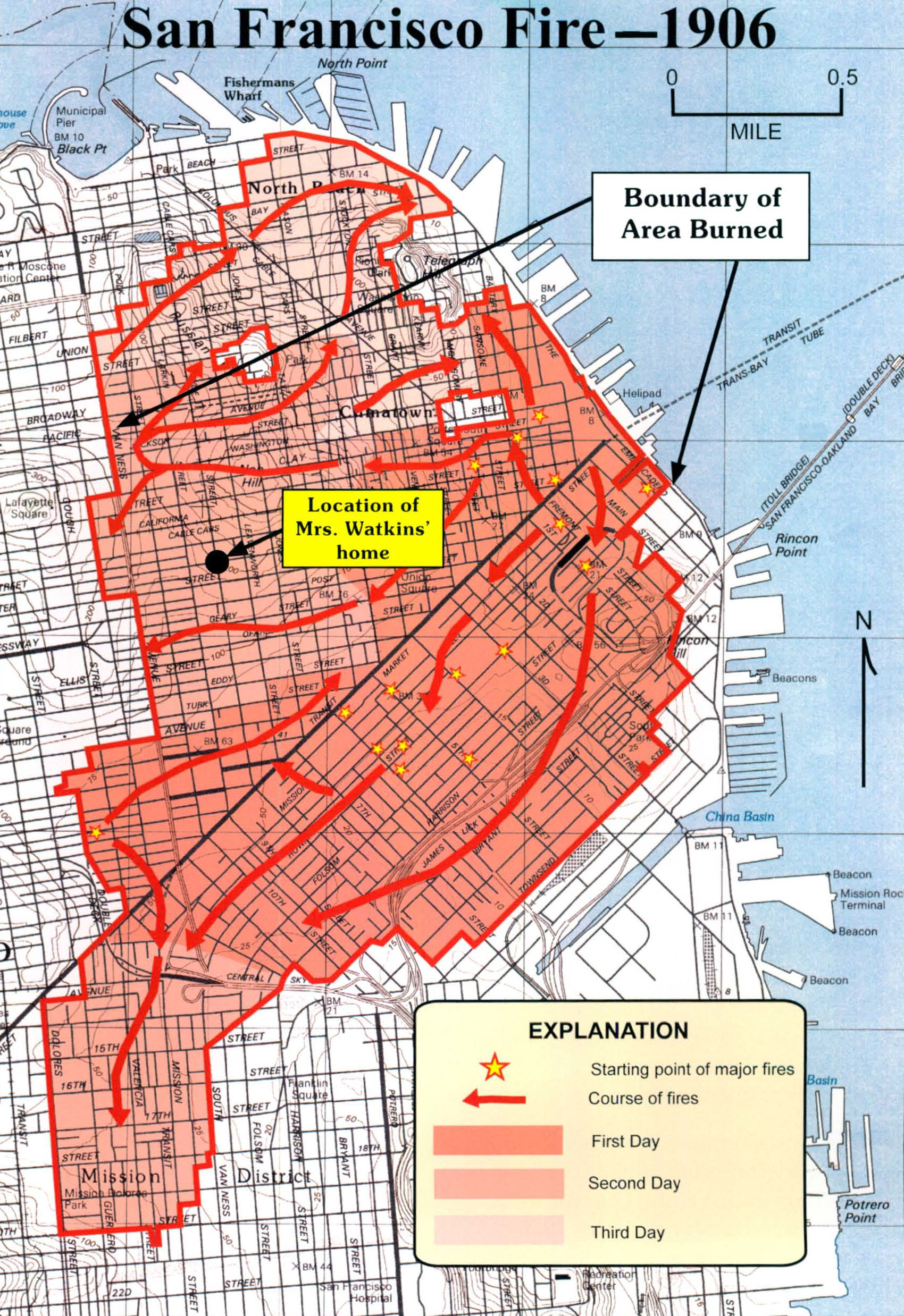 Map showing three-day progression of the fire that followed the earthquake. The map is modified from the first edition of William Bronson's book, "The Earth Shook…The Sky Burned" (1959). ' Attempts made by this publication's editors failed to find the original source of the map. However, the editors believe the information within the map was derived from the text of a 1908 Master's thesis by Lawrence Kennedy describing the progress of the fire.
 Lower Market Street San Francisco. Source: S.A. Moore, "The San Francisco Catastrophe"
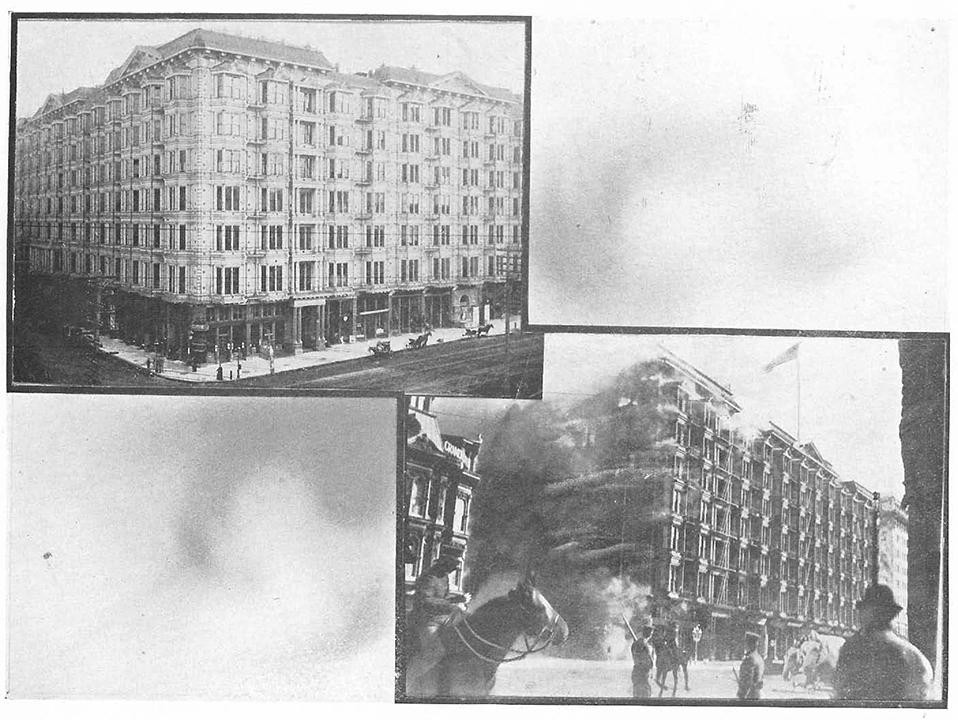 The Palace Hotel and the Palace Hotel in flames. For many years this was known as the finest hotel in the world. The edifice covered over two and one-half acres on Market Street, San Francisco's great business thoroughfare. It was rapidly destroyed by fire. Source: L.H. Nelson Company, "Views of San Francisco Before and after Its Destruction"
We saw the flames burst through the windows of the first building to burn on Market. We saw the fight to save the Palace Hotel—a historic landmark. We saw a fire break out on each side of Market, between us and the Ferry. We saw the troops coming, and the first dynamite brought, and still no one thought of the fire spreading to the northern part of the city. The water mains were broken by the earthquake, there was no water….
The soldiers were dynamiting the buildings along the fire line, so we decided to go home and make sure of our insurance papers and jewelry. Even then our friends laughed at us. It was a strange obsession. No one seemed to realize that there was no water, and each one believed that the fire could not reach him. Most people escaped with only the clothes that they wore. When the fire was within two squares of us, a woman in our house declared that our house could not burn and she would not pack her clothes….
The very poor could pack their possessions in a trunk, and drag it with a rope along the pavement for miles. I shall never forget that sound of dragging trunks, all night long. Some of the rich people saved their houses, for this one fourth of the city which still stands was one of the richest sections. But they suffered most in the business section. One of my ex-rich friends, with a big house, is already trying to get boarders.
We got our papers, life insurance, fire insurance, burglar insurance, and a few shares in an eastern company, bank books, check books, our jewelry, and what cash we had in the house. All this we concealed on our persons….I had almost $200. This was the only cash in the house. On this money, we and six other families have been living since the earthquake. I have heard of only one other person who saved so much cash. Men who were millionaires had only a dollar or two. I heard one young fellow remark cheerfully that he had lost everything and had 25 cents in his pocket, but that he was young, and did not need money.
The spirit of this people is the most wonderful thing I ever dreamed of, cheerful, happy, laughing while they were fleeing from the flames, saying nothing of what they had lost but rejoicing over their lives. I have seen one woman fainting and one in tears, that is all…. Humanity has showed up well. I am proud to call myself a San Franciscan….
We spent the night on the stone front steps [of the house], wrapped in blankets. No one slept, except the men took cat naps. We women could not sleep. I lay down for two hours on the couch in the reception room, but could not sleep…. Every few moments there was an explosion of dynamite, or a slight earthquake shock. Across the street was a vacant lot, where a big house was pulled down last summer. It was filled with people sleeping, rolled up in blankets. The streets were filled with trunks.
All night the crowds went by dragging, dragging trunks. It was a horrid sound. A man had a fit on the opposite pavement. A paralytic went by dragging his foot on the pavement, going towards the fire. An invalid was carried past in a big chair. A young mother trundled her baby in a gocart, with a bundle as big as a bushel hanging to the handle of the gocart. The baby sat up so straight and interested, watching the fire…. The father was dragging a trunk, with the rope over his shoulder. I shall always wonder if that baby escaped.
Wild rumors reached us constantly. Every half hour two of us walked down the street, to see for ourselves how the flames were. The sky was lit up with the awful glare for three-fourths of the Heavens; on the other side was the black fog from the sea. We could hear the crackle of flames, the crash of falling roofs and walls, the roar of dynamite. Showers of cinders fell over us, and continued to fall for three days and nights. Fortunately the heat was so fierce that the sparks went very far in the air and were cold before they reached the ground….
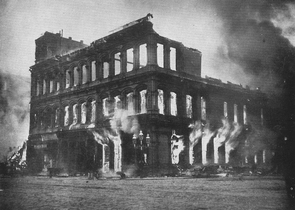
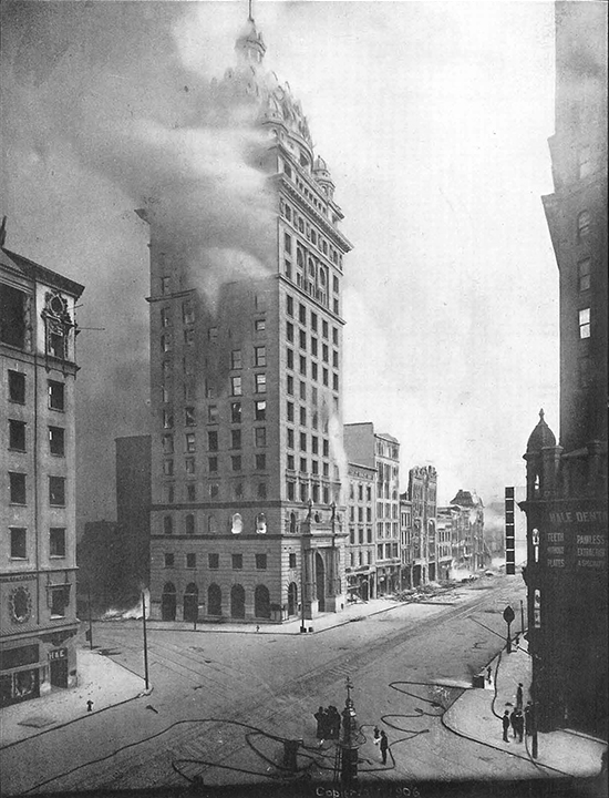 The Call Building in the grip of the fire. Source: Temple Smith, "Santa Rosa and Vicinity Before and After the Disaster"
 Smoldering ruins on Stockton Street, San Francisco. Source: S.A. Moore, "The San Francisco Catastrophe"
At about 5 A.M. the fire was within two squares of us on the south and west, so we gave it up and started [to leave for a safe area]…. Fortunately, there was no wind and the flames did not travel fast enough to endanger life except to some people who were hemmed in between the water and three lines of fire, on Russian Hill, but everything escaped as a rule….
Thursday night the fire crossed Van Ness in two places. It is the broadest street in the city, has no car lines, and divides this, the upper fourth of the city, from the three fourths that burned. Everyone felt that it was the last stand; if the fight was lost at Van Ness, the whole city would go. The military and fire department had started a back fire for two squares below Van Ness, which really saved the rest of the city…. The soldiers had adopted the plan of dynamiting every house that caught fire and the houses around it….
No words could describe what we saw from that hill. Flames as far as eye could reach, on three sides a roaring inferno of fire. Where the fire was almost burned out, the squares and houses were outlined by creeping things. The sky was a horrid glare around; round us on the grass were the refugees, mostly asleep, within a square of the flames, trusting to the soldiers to tell them to move on….
We are under martial law, and we have a vigilance committee. Sentries are posted on every corner, and it is comforting in the night to hear them call, "Twelve o'clock and all is well."…
We still have no water, except from a few isolated hydrants, from which it is carried. We are allowed to use it for drinking and cooking only. All cooking is done in the streets, on stoves or improvised brick ovens….
The Federal troops are guarding the ruins, the vaults, the post-office, and the mint. Any man caught stealing is shot down at once, or if he disobeys a soldier's first command. Anyone can leave San Francisco, but no one can come back, except with a government or Red Cross pass.
We stand in line to get food at the distributing station. The contents of the few grocery stores were seized at once by the troops, nothing can be bought in San Francisco. We have been living for the most part on what was brought from our house…. I believe there is no scarcity of food at the distributing stations; the only difficulty is transporting it from the receiving stations over such great distances, and distributing it to such vast multitudes.
Yesterday I walked down through the nearest camp. It covers about half a mile and is a comparatively small one. It is about a mile away from here on the water front, and in full view from our hill. Thousands of tents have been sent and distributed. The parks, the cemeteries and the Presidio, are full of campers, but they are too far for me to go. The cemetery vaults have been broken up, and people are sleeping in them. The city records have been stored in the vaults of the crematory, with soldiers guarding them.
The people in these low, shelter tents are cheerful and uncomplaining. It is wonderful, wonderful. Forty babies were born in the Park in one night. One case was triplets. Many emergency Hospitals have been started, in barns, churches, etc. I spend much of my time at the headquarters of the Red Cross and the Doctors' Daughters. Jim [Eleanor's husband] is busy all day with Red Cross work. It is all charity. No Doctor charges anything these days….
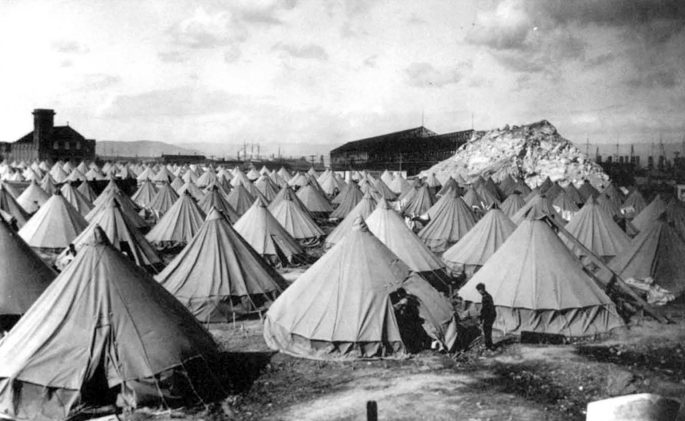 Thousands of tents sheltering refugees of the earthquake. Source: California Geological Survey archives
The death rate will never be known, but it is guessed at 2,000. This is comparatively small, when there are 300,000 homeless. If the earthquake had happened two or three hours later, there would have been thousands of deaths in the business buildings and on the streets….
Not less wonderful than San Francisco's heroism has been the quick generosity of the country and other countries. I believe the relief fund has reached ten million dollars. This will not last long, feeding three hundred thousand at thirty cents a day, and they must all begin again. Many trains of supplies have come in; if anyone has starved, it must surely have been his own fault. Doctors and nurses have come by the train load. Perhaps God sent it to show how good the world is after all—or to develop its goodness….
The people are wonderful, wonderful. San Francisco is going to rebuild and quickly. Nothing is left except a small residence section on Pacific Heights, a miserable little second-class business street (Fillmore St.), and small residences in the outlying districts….
The slight earthquakes continue—two last night, and quite a severe shake at noon. They say it is the settling of the earth after the main upheaval….
No one can know yet what is ahead of us. Our dear love and thanks go to you all. We can hardly think of anything except the present situation and not much about our own troubles. This is an unprecedented situation, and there are no rules to go by. Each day has new developments, and no day is like the last.
Lovingly, Eleanor
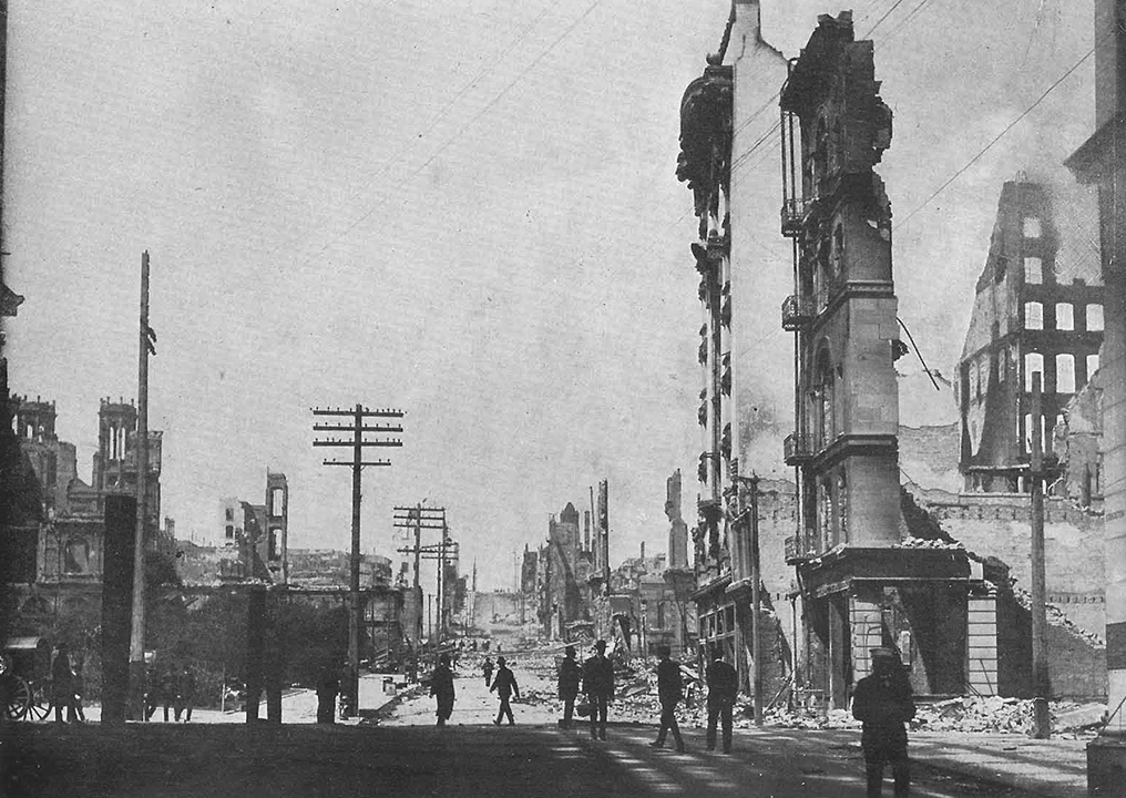
 View north east from Nob Hill. Source: F.A. Webster, "View album San Francisco Earthquake and Fire Ruins"
Observations from Palo Alto
The following excerpts are from an article written by Dr. Olaf P. Jenkins in the April 1980 edition of CALIFORNIA GEOLOGY™ magazine. At the time of the "Great Earthquake," Dr. Jenkins was a high school student in the city of Palo Alto. Even at an early age, Dr. Jenkins knew he wanted to become a geologist and, as evidenced by his curiosity and exploration to the area of earthquake fault rupture, he was destined for great things in the field. He went on to become the Chief and State Geologist of the California Division of Mines (now known as the California Geological Survey) from 1928 to 1958.
[After the earthquake] I jumped up to look out my little window on the third floor of our home on the Stanford University campus. The view was of the beautiful sandstone buildings of Stanford University; but now there was a great cloud of dust rising. Only when the dust started to settle could I make out that not all was there. The 100–foot stone Chimney was gone!…
And the dome of the Chapel, Mrs. Stanford's joy and pride, was gone too!…
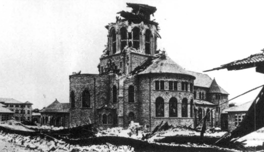 Stanford's dome of the Chapel destroyed by the earthquake. Image courtesy of California Geological Survey
[Our] house seemed to be in good shape-how could it, after having gone through such a shake?
After breakfast we decided to try living out on the lawn under the trees for a while, at least during the day, to avoid the effects of aftershocks. We ate out there, where we could meet and talk to others and learn what all had happened. We could hear rumbling from far–off San Francisco—blasting of buildings to clear them in front of the great fire which was reported to be sweeping over the city, uncontrolled because of complete lack of water….
Near at hand we found out that when Stanford's great Chimney fell, the guard ran out and it fell on him and killed him. If he had stayed where he was, sitting in a chair at the foot of the Chimney taking care of the furnace, he would have been safe, for the chair still remained untouched. The Chimney fell across a long arcade which went down like a row of nine pins. The Chapel back of it suffered not only the collapsed dome, but the fine mosaic across its front was jerked off and now lay in slabs on the sidewalk below.
Most of the recent buildings were damaged more than the older ones. The great top–heavy arch facing the front of the University was split, but not hurled down as one would have expected; the keystones on many of the smaller arches were dropped slightly. Encino Hall, the boys' dormitory, had one particularly bad spot: a section of a room on the top story dropped straight down, carrying the rooms below with it.
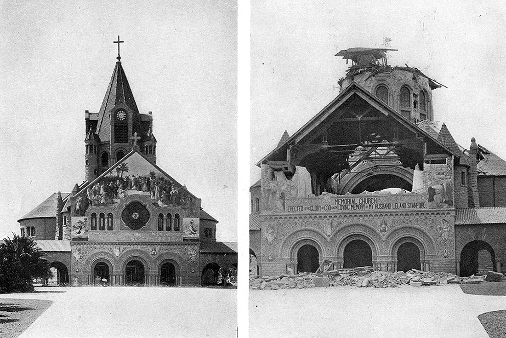 Memorial Chapel, Stanford University. Source: E.P. Charlton, "Views of San Francisco Before and After Earthquake"
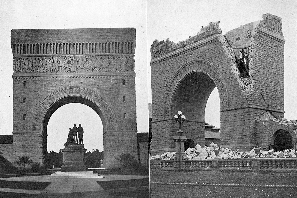 Memorial Arch, Stanford University. Source: E.P. Charlton, "Views of San Francisco Before and After Earthquake"
Near the University buildings a bookstore which was made of brick collapsed. It was said that the mortar did not contain sufficient cement and the bricks had not been properly wetted before being set up. There was plenty of criticism of materials and workmanship everywhere we went, but the shake was more severe than most people realized….
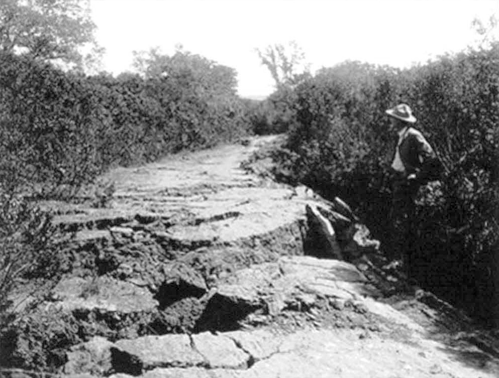 [In Portola Valley] the ground in places was all churned up. Image courtesy of California Geological Survey
[In Portola Valley] the ground in places was all churned up. We came across a great oak that had been split in two; the upper branches were still intact, but the lower trunk and roots had been pulled apart, the west half going north while the east half was pulled south. We were on the great Portola fault (now known as the San Andreas fault). A little way farther on there was a country store or house where the front porch had been carried north, separating it from the rest of the house, for the fault crack ran between them.
I was already quite familiar with all this country, especially Alpine Road where it climbed Black Mountain, for it went to some of my favorite camping places. A few days before the earthquake I was on this mountain road with some other boys to examine the road damage caused by the recent heavy rains. We now found that landslides had torn out the road. I can remember where the slides exposed some small coal seams and clay beds on which they had moved. Later, we read in the newspaper that the earthquake had caused the slides and that cattle had been trapped in a valley because landslides closed off the front of the steep sided valley. No doubt the earthquake helped the slides along, but the heavy rains had started them.
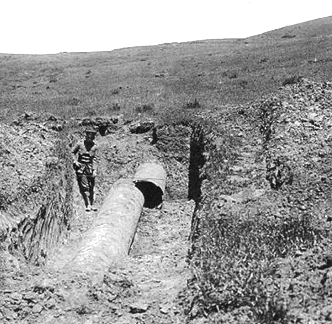 Water main leading from Crystal Springs Reservoir to San Francisco. Image courtesy of California Geological Survey
Continuing our journey of exploration along the great fault, we saw most of the examples of earthquake disturbance that were to be photographed and published many times over in various books.
Near Searsville Lake the road was torn up as if a giant plow had been down the middle of it. Displaced fences were quite common. One particularly impressive thing we saw was where the huge water main, leading from Crystal Springs Reservoir to San Francisco and built right along the fault line, had been torn apart in places. Where it crossed the fault from east to west this strong pipe was jerked and pulled apart several feet; but [in other places] it had been rudely telescoped several feet. The force that it took to do that destruction simply amazed us. It was certain that anything in line of the moving fault had to give and that feature many people found hard to believe. Very few people at that time had given a single thought to earthquakes, and even now it takes a lot of explaining to get the fact across….
 Fence displaced after earthquake. Image courtesey of California Geological Survey
The Earthquake Trail at Point Reyes National Seashore
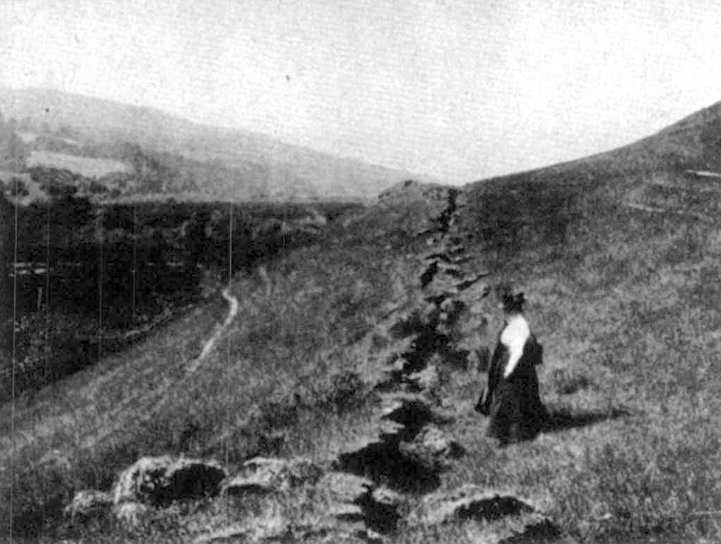 Surface fault rupture from the 1906 earthquake through the Skinner Ranch, Marin County. Source: G.K. Gilbert"
As the reader can gather from Olaf Jenkins' observations in the previous article, the surface rupture along the San Andreas fault from the 1906 earthquake was quite significant in the Portola Valley area, offsetting roads, fences, pipelines, and even tree trunks. However, the maximum displacement from the earthquake occurred 30 miles north of San Francisco, in the area now designated Point Reyes National Seashore. The San Andreas fault ruptured approximately 20 feet laterally in this area.
To capture this geologically significant event for future generations, the National Seashore created an "earthquake trail" along which visitors can follow the location of the surface rupture from the San Andreas fault where it sliced through the area in 1906. The following excerpt and some of the images are from two CALIFORNIA GEOLOGY™ articles (April 1974 and September 1976) describing the hard work by volunteers from Foothill College, Los Altos Hills, Santa Clara County in refurbishing this interpretive trail.
The Point Reyes Peninsula has been called an "Island in Time." Geologically speaking the park is an "island" of granite bedrock that has slid into its present position from southern California along the San Andreas fault. This great fault system marks the boundary between two great plates of the earth's crust which have been grinding slowly past each other for millions of years. Friction along the plate boundaries causes the plates to move with a series of destructive "jerks" or jumps which generate earthquakes like the 1906 episode. Since the plates continue to move and build up the energy stored along the fault, Bay Area residents can expect more major shakes in their future. This earthquake trail is dedicated to helping Bay Area residents better understand their physical environment so that they can minimize the geologic hazards posed by it.
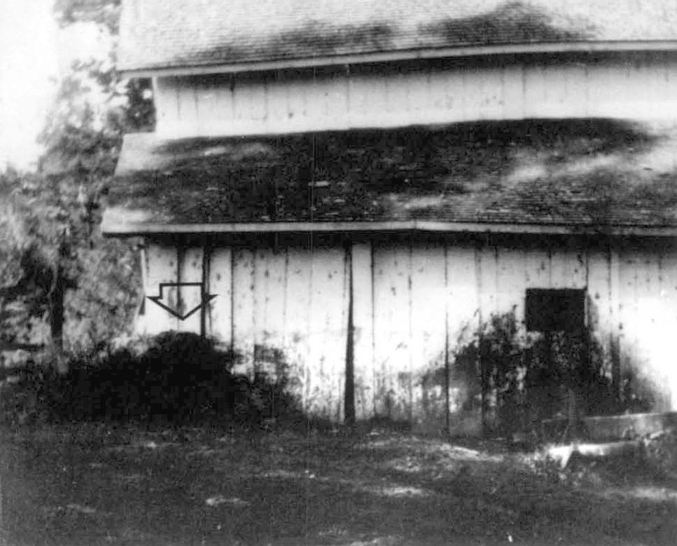 Offset deposits provide evidence for plate movement. All but the southeast corner of the Skinner barn, pictured here, was situated on the Pacific Plate side of the San Andreas fault. When the crust moved, the barn remained intact but the southeast corner was shifted 15 feet off its foundation. Notice the dark conical stain on the barn wall beneath the window. The deposit of "biogenic colluvium" (manure) indicated by the arrow is now 15 feet from its point (or window) of origin. Source: J. C. Branner collection, courtesy of Stanford University
The following two photographs were taken in nearly the same location, but 100 years apart.
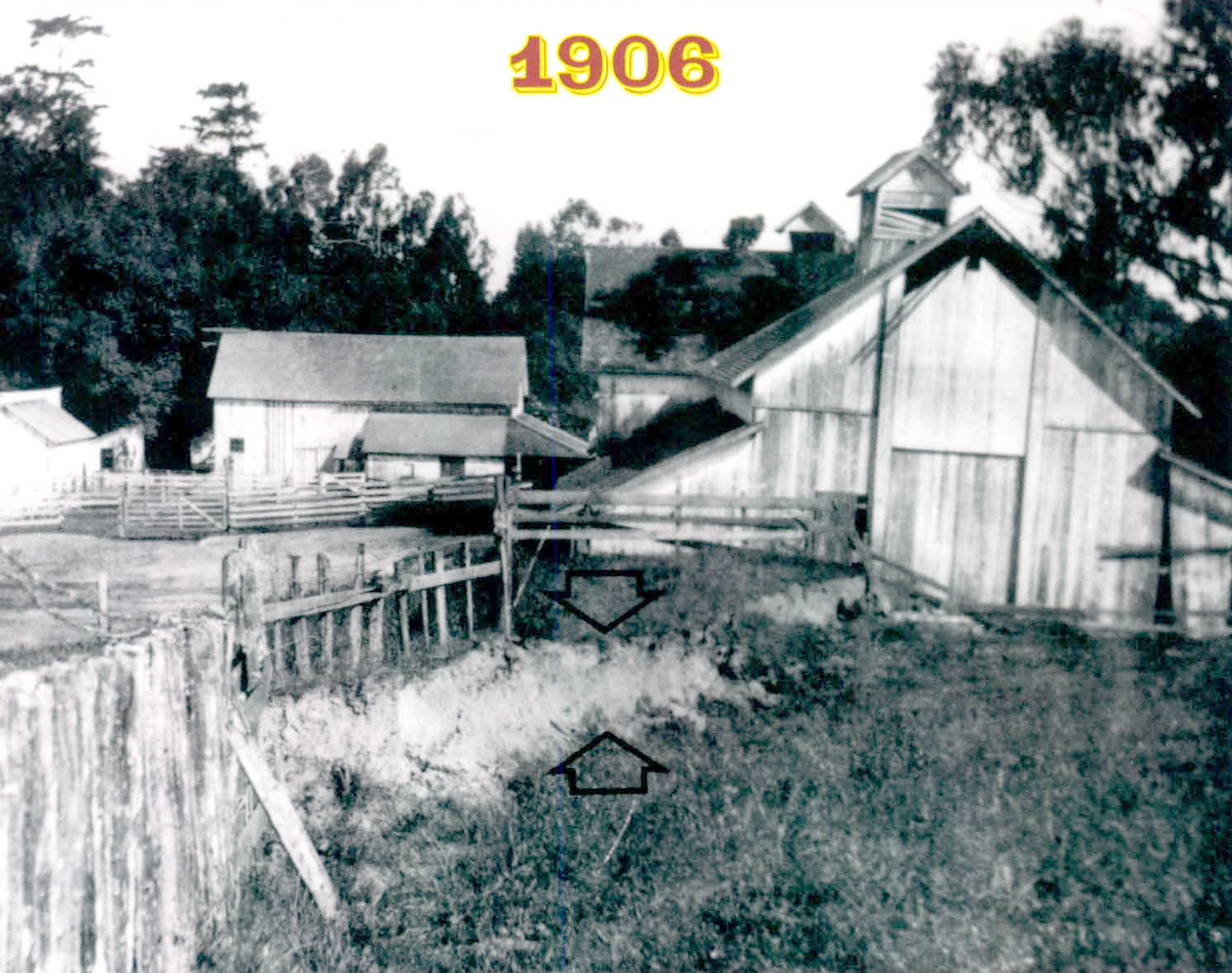 Skinner barn, 1906. This photo shows surface fault rupture from the "Great Earthquake" as it cuts through the edge of the Skinner barn to the right. Source: J. C. Branner collection, courtesy of Stanford University
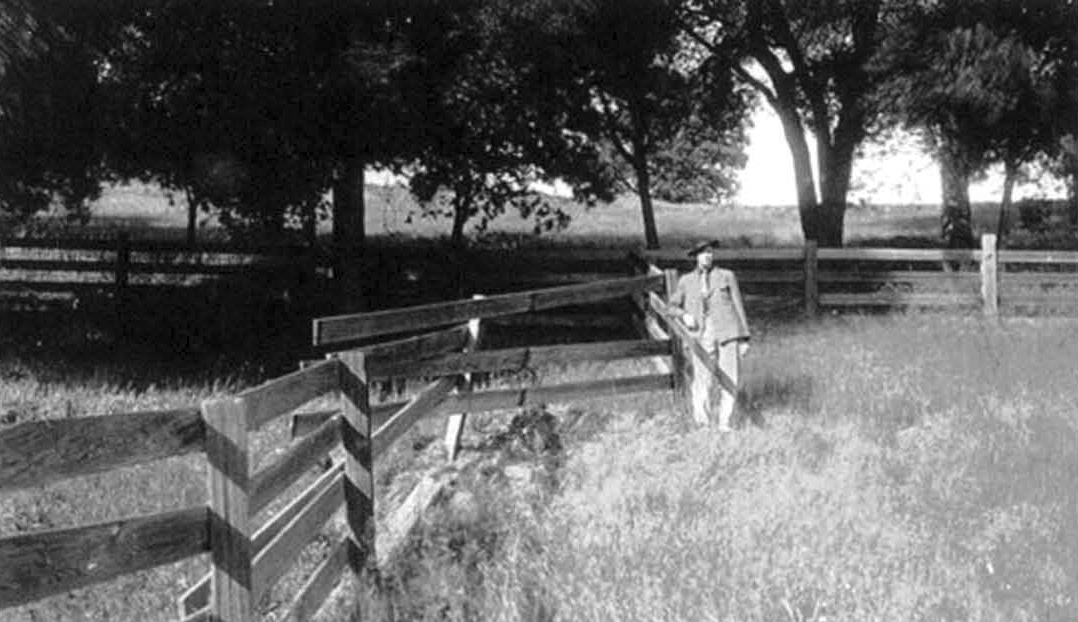
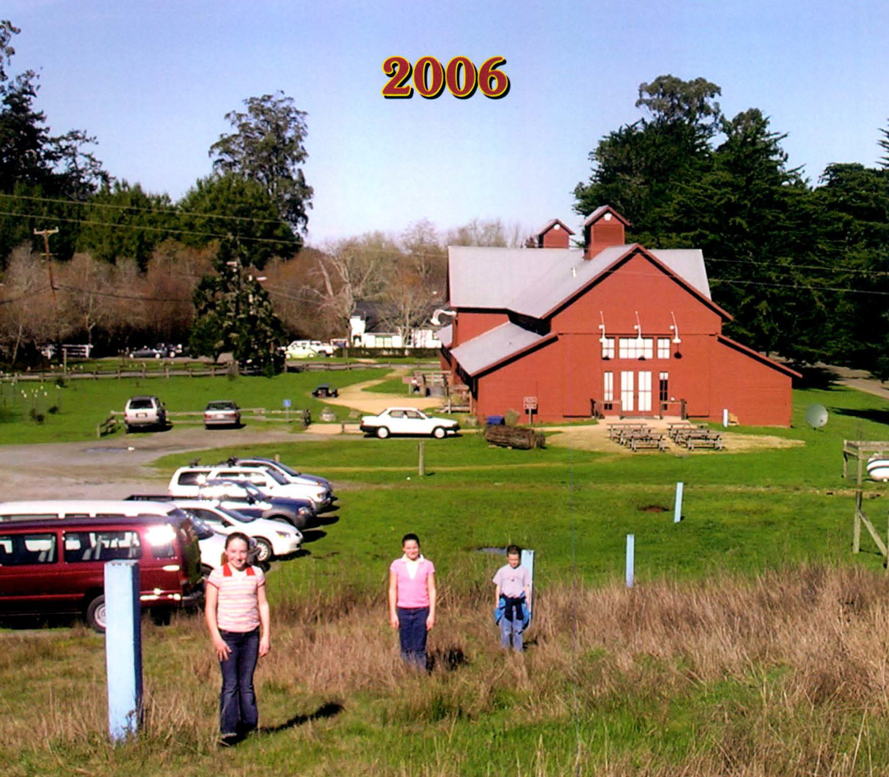 Skinner barn, 2006. This photo shows the trace of the old surface rupture marked by blue posts (and three children). Other than the markers, there is no surface evidence of the fault rupture. It has disappeared (likely eroded) over the past 100 years, demonstrating the difficulty geologists face in locating active faults.Source: Rick Wilson, California Geological Survey
Additional Reading
 The court house, Santa Rosa, after the disaster. Source: Temple Smith, "Santa Rosa and Vicinity Before and After the Disaster"
The Point Reyes National Seashore website: https://www.nps.gov/pore/index.htm
The Great 1906 San Francisco Earthquake - US Geological Survey, Earthquake Hazards Program. https://earthquake.usgs.gov/
Modified Mercalli Intensity Maps for the 1906 San Francisco Earthquake Plotted in ShakeMap Format - US Geological Survey. https://pubs.usgs.gov/of/2005/1135/
The Great 1906 Earthquake And Fire - The Virtual Museum of the City of San Francisco. https://www.sfmuseum.org/1906/06.html
The Great Shake: San Francisco, 1906 - Exploratorium, San Francisco. https://www.exploratorium.edu/faultline/great/1906/index.html
Source Study of the 1906 San Francisco Earthquake - Caltech AUTHORS, A Caltech Library Service. https://authors.library.caltech.edu/records/tmnhr-7ha12
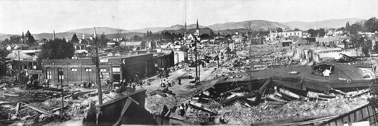 Santa Rosa and vicinity after the disaster. Source: Temple Smith, "Santa Rosa and Vicinity Before and After the Disaster"
Links to Historical Photographs and Artwork Collections
Photo Exhibit - San Francisco Earthquake, 1906 - The Virtual Museum of the City of San Francisco. http://www.sfmuseum.org/1906/photos.html
San Francisco Earthquake and Fire Stereographs, 1906 - The Bancroft Library, UC Berkeley. https://oac.cdlib.org/findaid/ark:/13030/tf5h4nb721/admin/
Photographs of Damage From the 1906 San Francisco Earthquake - M.L. Whittington, Saint Louis University. https://www.eas.slu.edu/eqc/eqc_photos/1906EQ/
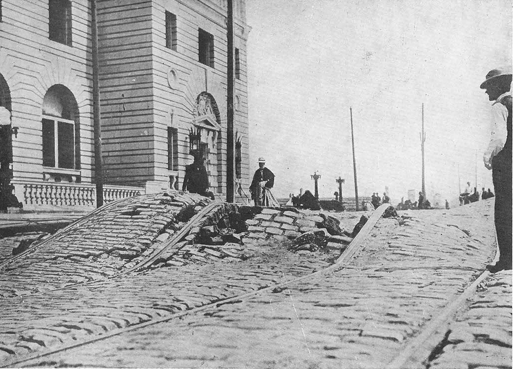
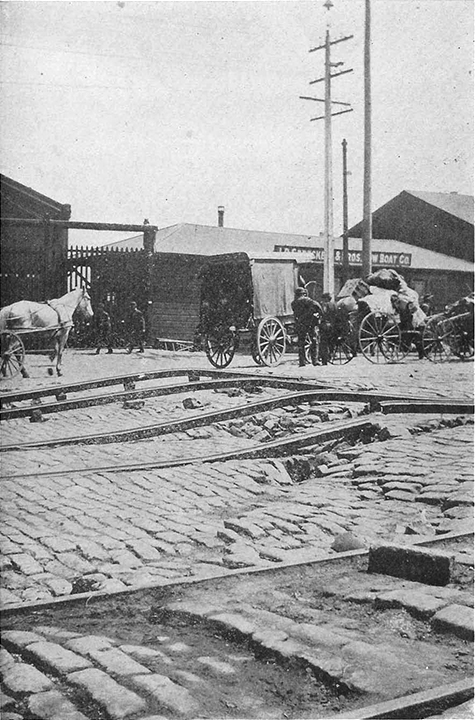 A few crimps in the ground along the waterfront. Source: S.A. Moore, "The San Francisco Catastrophe"
