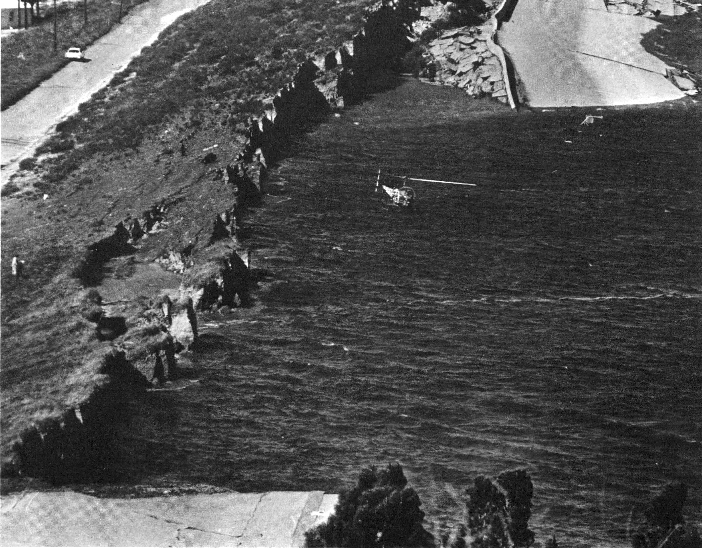
 Lower Van Norman Dam: earthquake damage to this earth-fill dam posed a major flood threat. Photo credit: Los Angeles Times. Source: CALIFORNIA GEOLOGY magazine, April-May 1971.
Earthquake summary
- Date: Tue Feb 9, 1971
- Time: 06:00:41 AM PST
- Location: N34.42 W118.40: San Fernando
- Name: San Fernando Earthquake
- Magnitude: 6.6
On February 9, 1971 at 6:01 am PST, a devastating M6.6 earthquake struck the densely populated metropolitan area of Los Angeles, leaving death and destruction in its wake. The epicenter of the earthquake was in the vicinity of Magic Mountain, about six miles northeast of Sylmar, at a depth of about seven miles. The shock was felt for 300 miles along the southern California coastal region and as far inland as Las Vegas, Nevada. The greatest damage was in the San Fernando area northwest of Los Angeles. The earthquake resulted in 65 deaths and more than 2,000 people injured. Property damage losses totaled more than half a billion dollars.
San Fernando ’71: the Earthquake that Made Us Safer
View a gallery of archival photos at our blog:
Notes From the Field
Hospitals were severely damaged; freeway interchanges collapsed; and a reservoir was in imminent danger of failure, forcing nearly 80,000 residents who lived downstream to evacuate. Movement along the fault reached the surface during the earthquake and extended 12.5 miles from the San Fernando-Sylmar area in the northern San Fernando Valley to Big Tujunga Wash in the Sunland area. Along this zone, many additional structures sitting on top of the fault zone were severely damaged directly by fault movement at the surface.
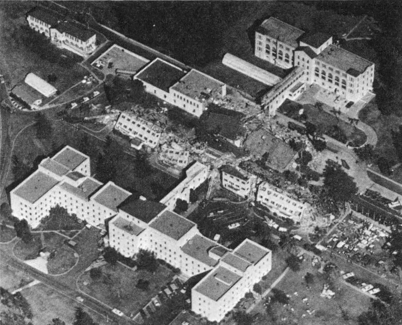 Aerial view of damage at Sylmar Veterans Administration Hospital. Photo credit: Los Angeles Times. Source: CALIFORNIA GEOLOGY magazine, April-May 1971.
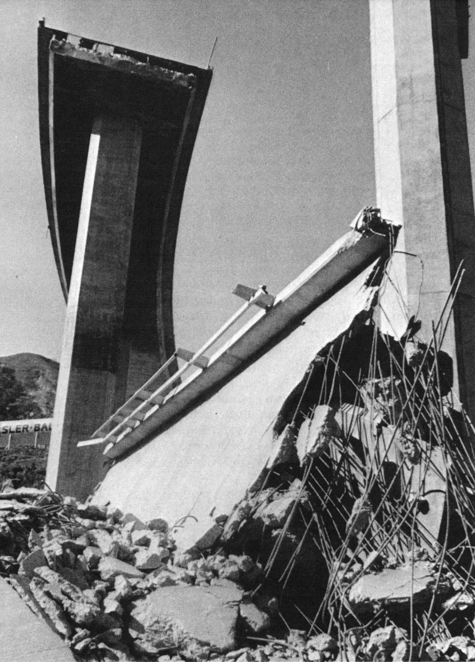 Collapsed overpass at intersection of Sierra Highway and Golden State Freeway. Photo credit: Newhall Signal. Source: CALIFORNIA GEOLOGY magazine, April-May 1971.
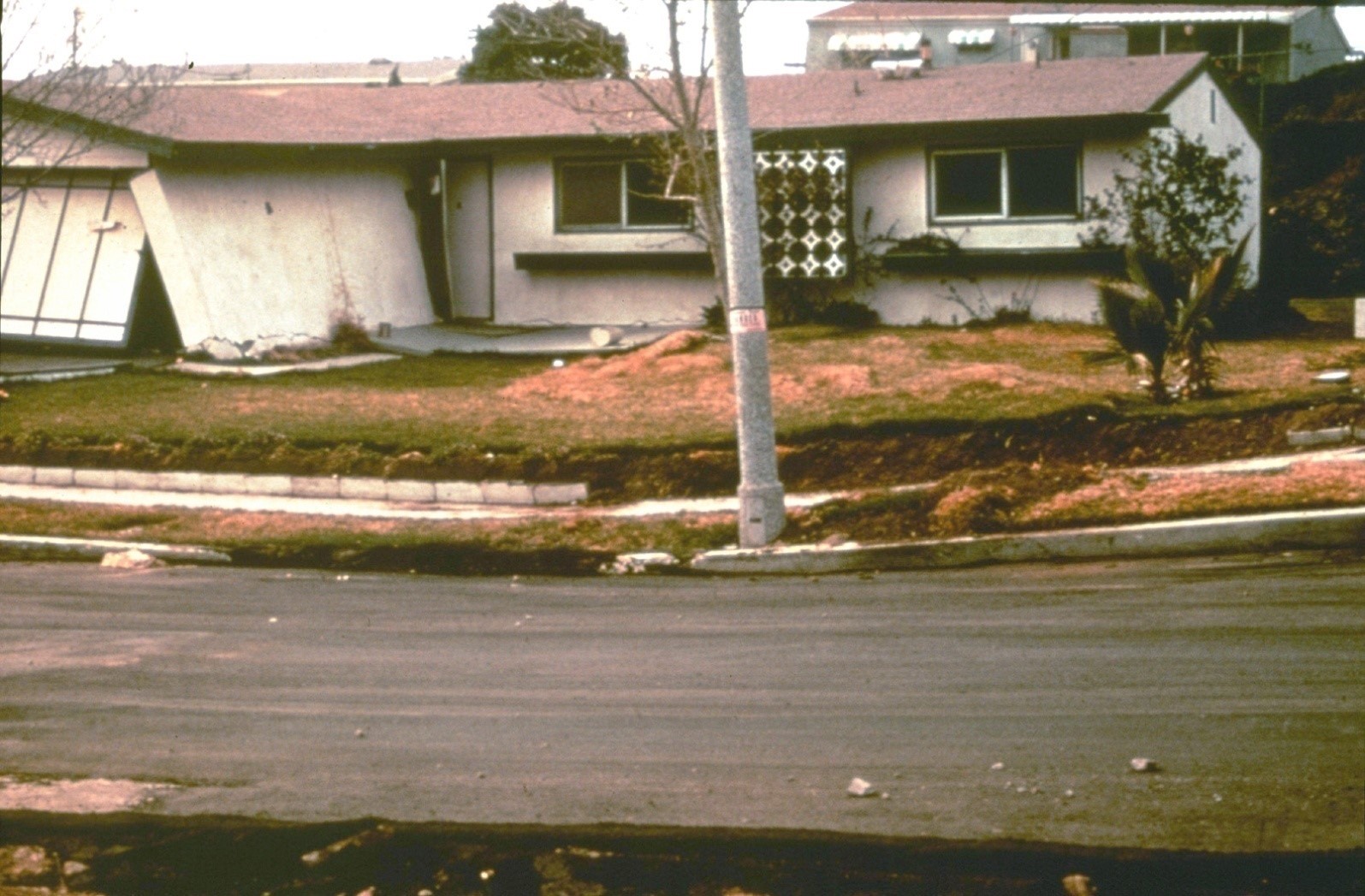 A single family residence damaged by fault rupture. The location of the fault is evident in the sloping sidewalk and crumpled lawn. Photo credit: Earl Hart, CGS.
Lessons learned
California is safer because of the 1971 earthquake. Visit our Story Map: Remembering the San Fernando Earthquake of 1971 to see then-and-now photos, and to learn more about the Alquist-Priolo Earthquake Fault Zoning Act, one of four pieces of major legislation that resulted from the earthquake.

Significant legislation followed the San Fernando earthquake, designed to mitigate the impact of future earthquakes. Today the California Geological Survey continues to work towards a more earthquake-resilient California through several programs mandated by these laws, including:
The Strong Motion Instrumentation Program (SMIP) was established in 1971 to help seismologists and engineers better understand the effects of ground motion on structures. The California Geological Survey maintains a statewide system of thousands of data-collecting instruments that record how the ground, bridges, skyscrapers, dams, and other structures respond to shaking. SMIP’s data influences building codes, resulting in structures that are more earthquake resistant. Many of the instruments are being modified to also contribute data to California’s earthquake early warning system.
Alquist-Priolo Earthquake Fault Zones, (APEFZs) regulate the construction of buildings across the traces of active faults to mitigate damage from surface fault rupture. The California Geological Survey produces maps of active faults and establishes Earthquake Zones of Required Investigation surrounding these faults.
The Hospital Safety Act of 1972 requires, in part, the consideration of geological and seismological issues to ensure new or retrofitted hospital buildings are sited, designed, and constructed to remain operable following earthquakes. The California Geological Survey reviews the geotechnical and seismic aspects of hospital and public school construction throughout California.
The 1971 earthquake illustrated the need for better coordination between scientists, engineers, and emergency responders and led to the establishment of the first Earthquake Clearinghouse. Following a major earthquake, CGS and its partners convene the California Earthquake Clearinghouse to coordinate earthquake field investigations and share observations.
Did You Feel It?
The United States Geological Survey is still accepting "felt" reports for historic earthquakes. If you remember feeling the earthquake in '71, go contribute to the DYFI map:
USGS 'Did You Feel It?'
References
Read more
- FACT SHEET: 50th Anniversary of the San Fernando (Sylmar) Earthquake
- CDMG Bulletin 196: San Fernando, California, earthquake of 9 February 1971
- Geologic map of the San Gabriel Mountains, California (CDMG Bulletin 196, Plate 1)
- Geologic map of the San Fernando Earthquake area (CDMG Bulletin 196, Plate 2)
- Surface effects map of the San Fernando Earthquake area (CDMG Bulletin 196, Plate 3)
- Geologic section across San Fernando Earthquake fault scarp exposed in trench near mouth of Lopez Canyon (CDMG Bulletin 196, Plate 4)
- Geologic cross-sections of the Sylmar-San Fernando area (CDMG Bulletin 196, Plate 5)
- CDMG Preliminary Report 11: Map of surface breaks resulting from the San Fernando, California, earthquake of February 9, 1971
- [external page] Earthquake Overview – M 6.6 10km SSW of Agua Dulce, CA (1971 San Fernando earthquake) – United States Geological Survey
- [external page] Earthquake Photo Collections – 1971 San Fernando, CA – United States Geological Survey
- [external page] The Disaster that Helped the Nation Prepare for Future Earthquakes: Remembering San Fernando – United States Geological Survey
- [external page] 1971 San Fernando earthquake - Wikipedia
Web page by:
California Geological Survey - Seismic Hazards Program
