The Seismic Hazards Program delineates areas prone to ground failure and other earthquake-related hazards including soil liquefaction (the failure of water-saturated soil), earthquake-induced landslides, surface fault rupture, and tsunami inundation. Cities and counties are required to use these maps in their land-use planning and building permit processes so that these hazards are identified and mitigated for development projects prior to the next major earthquake. Additionally, the program reviews and provides comments on geologic and seismic hazards that apply directly to the design and construction of essential and critical facilities around the state. These facilities include schools, hospitals, nuclear power plants, hazardous waste repositories, and others, typically under contract to other state agencies. The program compiles information about past earthquakes, the potential for earthquakes on major faults, and rates of deformation across California to estimate the potential for future earthquakes. The Seismic Hazards Program works closely with the U.S. Geological Survey to produce earthquake shaking maps that are used in development of building codes and in earthquake damage and loss estimates.
Functions and Products of the Seismic Hazards Program
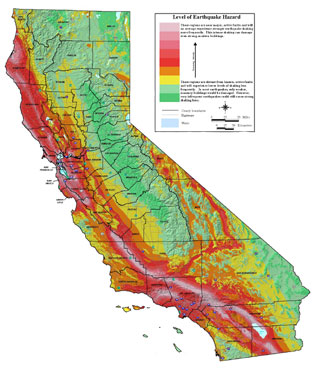
Seismic Hazards and Zones of Required Investigation
 The Alquist-Priolo Earthquake Fault Zoning Act (1972) and the Seismic Hazards Mapping Act (1990) direct the State Geologist to delineate regulatory "Zones of Required Investigation" to reduce the threat to public health and safety and to minimize the loss of life and property posed by earthquake-triggered ground failures and other hazards. Cities and counties affected by the zones must regulate certain development projects within them. These Acts also require sellers of real property (and their agents) within a mapped hazard zone to disclose at the time of sale that the property lies within such a zone. Studies of faults result in estimates of maximum earthquake magnitudes and long-term slip rates that are the basic input for seismic hazard calculations. Consensus values are compiled by CGS in cooperation with USGS.
Zones of required investigation for possible earthquake faulting, liquefaction, landslides, and tsunamis are delineated and distributed to cities, counties, and state construction agencies to help identify where higher building standards may be necessary for safe development. They include Alquist-Priolo Earthquake Fault Zones, Seismic Hazard Zones (liquefaction and earthquake-induced landslides), and Tsunami Regulatory Zones.
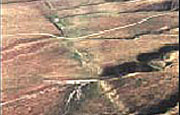
 Alquist-Priolo Earthquake Fault Zones prevent buildings for human occupancy from being constructed upon active faults. Statutes require that cities and counties use these zones as part of their construction permitting process.
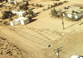
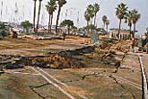 Liquefaction Zones identify where the stability of foundation soils must be investigated, and countermeasures undertaken in the design and construction of buildings for human occupancy. Statutes require that cities and counties use these zones as part of their construction permitting process.
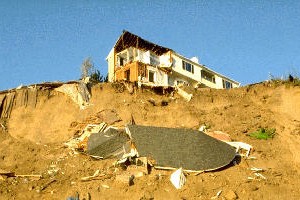 Landslide Zones identify where the stability of hillslopes must be evaluated, and countermeasures undertaken in the design and construction of buildings for human occupancy. Statutes require that cities and counties use these zones as part of their construction permitting process.
Tsunami Zones (initial maps completed in Summer 2021) identify where the impacts from tsunami inundation and related hazards must be evaluated and countermeasures, including evacuation and engineering design, be developed to protect the human occupants. Statutes require that cities and counties use these zones as part of their construction permitting process.
Seismic Hazard Maps, Reports & GIS Data
Find and download the following products through our Information Warehouse: Regulatory Maps tool.
Learn how and why the California Geological Survey maps areas susceptible to earthquake hazards and helps mitigate these risks by providing helpful scientific information.
-
Earthquake Zones of Required Investigation Maps (EZRIM): Maps showing faults, fault traces, liquefaction zones and earthquake-induced landslide zones. Available as PDF and GIS Data.
-
Seismic Hazard Zone Reports (SHZR) and Fault Evaluation Reports (FER): these reports are provided to accompany and support the Earthquake Zones of Required Investigation Maps. They summarize the methods and sources of information used to prepare the maps. Available as PDF.
School, Hospital, and Environmental Reviews
 CGS reviews a number of environmental documents and provides comments relating to geologic hazards and issues that apply directly to assessing the potential impacts of land-use modification. As part of this process, CGS provides site reviews on consulting reports in geology, seismology, and geotechnical engineering for public school and hospital construction. Visit our School, Hospital, and Environmental Reviews page for more information.
Seismic Hazard Assessment, Earthquake Loss Estimation, and Earthquake Planning Scenarios
 Earthquake loss estimation and planning scenarios quantify seismic risk based on seismic hazard and exposure and vulnerability of the built environment. Seismic hazards are calculated considering consensus values for earthquake rates based on earthquake history, fault slip rates, and site soil types. The seismic hazard information is combined considering the potential for earthquakes on all seismic sources, and the level of ground shaking that would be caused by those earthquakes. The result is expressed as the level of ground shaking (expressed as a percentage of gravity) that on average occurs every 500 years. These statewide estimates of seismic hazards can then be used to estimate the potential of future earthquake losses. Such studies need to be frequently updated because of continuing development of the built environment and evolving technology in earthquake ground motion prediction and seismic hazard assessments. CGS also updates its scenario- and probabilistic-based loss estimations when significant developments occur in ground motion hazard analyses and in built environment.
Curation of Geotechnical Reports
The Policies and Criteria of the State Mining and Geology Board, with respect to the Alquist-Priolo Earthquake Fault Zoning Act (California Code of Regulations, Section 3603(f)), requires lead agencies to file copies of geologic reports of fault studies with the State Geologist within 30 days of its approval. Similarly, the Seismic Hazards Mapping Act (Section 2697(a)) requires cities and counties to submit a copy of each approved geologic/geotechnical report, prepared as a result of the presence of a Seismic Hazard Zone, to the State Geologist within 30 days of its approval.
To submit such reports and associated documentation of approval, visit our Seismic Hazard Zone Reports upload page.
We welcome your feedback. Please submit comments or questions to the Seismic Hazards Program via email.
