Map Compilation--Then and Now
The process of making an Important Farmland Map has evolved tremendously, along with computer technology and the internet. Historically, FMMP compiled the land use information on 1:24,000 USGS paper quads, referring to hard copy aerial photos and soil maps, and hand-transferring information. Processing large GIS files was unwieldy and time consuming, and the hand-transfer of information lead to incremental spatial inaccuracies each time maps were updated.
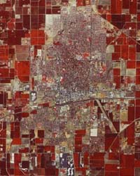
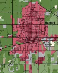
Between 1998 and 2002, FMMP transitioned the mapping process to a 'heads-up digitizing' workflow in which all data sources (digital photography, soil lines, field notations, reference maps) are co-registered and digitizing is done on screen. Examples of a color infrared air photo and resulting map, in the Hanford area, are below. These changes, along with today's many internet resources, improved the spatial and classification accuracy of the Important Farmland Maps.
Soil data was also historically in paper format, but is now available in GIS format from the USDA -NRCS . FMMP completed incorporation of digital soil (SSURGO) data (now Gridded Soil Survey (gSSURGO) data) into the Important Farmland Maps during the 2004 update. Gridded Soil Survey
(gSSURGO) data is available for download at the Geospatial Data Gateway.
At its core, however, the mapping process is much the same as it has been since 1984: existing maps are compared to new air photos in order to discern land use changes that occurred in the two years between updates. Notes from prior mapping analysts or from outside reviewers are used to document the nature of changes. Areas that are questionable or that lack photographic coverage are field verified, if possible. FMMP staff review each other's work before new statistics are generated. The statistics are analyzed to determine anomalies or the need for footnotes. Finally, new maps are released--the information is available in PDF format, as raw GIS data, or as print products.
Aerial photos are obtained from the private sector or governmental agencies. The cost, availability of existing photo coverage, and photo format dictate which photos are actually used in a given update. In recent years, since 2010, USDA National Agriculture Imagery Program (NAIP) imagery has been used. NAIP information is available at the USDA NAIP GeoHub and is available for download to the public at the Geospatial Data Gateway.
The FMMP staff continues to work on process improvements and look for cooperative opportunities to gather information. Please email FMMP to discuss our work anytime!
Making Important Farmland Maps Links
