The Earthquake
On April 25, 1992, a large earthquake (MW7.2) and powerful aftershocks rocked the Cape Mendocino area of Humboldt County in California. The shaking was felt throughout much of northern California and in southern Oregon.
The epicenter was onshore near Petrolia at the south end of the Cascadia subduction zone, a tectonic plate boundary where the Gorda and North America plates converge (move toward each other). This area is one of California's most geologically complex and seismically active areas.
Following the earthquake, the USGS found that twelve benchmarks within 60 miles (100 km) of the epicenter had moved measurably, some by as much as sixteen inches (40 cm) horizontally and six inches (15 cm) vertically.
Locations and magnitudes of the 1992 Cape Mendocino earthquake and two largest aftershocks. Sources: Mattison and others, 1992.
| 4/25/92 |
11:06:04 |
40.37 |
124.31 |
15km |
7.2 |
| 4/26/92 |
00:41:40 |
40.44 |
124.58 |
18km |
6.5 |
| 4/26/92 |
04:18:26 |
40.40 |
124.56 |
21km |
6.6 |
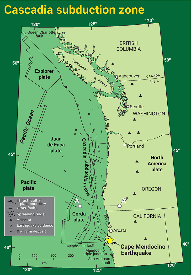 Map of the Cascadia subduction zone and related features. The epicenter for the 1992 Cape Mendocino earthquake is shown as a yellow star. Note cross-section A-A', which is discussed in the next figure. Click/tap the image to open a high-resolution version. Source: Modified from Nelson et al., 2004.
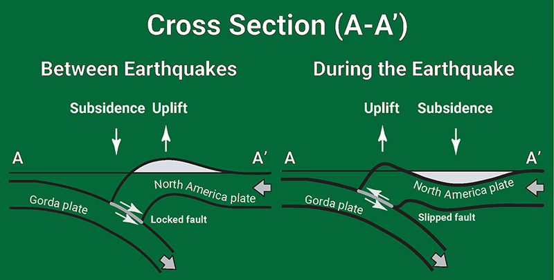 A cross-section showing typical tectonic plate interaction in the Cascadia subduction zone. This is cross-section A-A' from the map above. Between earthquakes, tectonic stresses cause subsidence in some areas and uplift in others. When the stresses release during an earthquake, the subsided areas 'rebound' up, while the uplifted areas sink down. Click/tap the image to open a high-resolution version. Source: Modified from Savage, 1983.
The earthquake and aftershocks damaged buildings, roads, and bridges, and triggered numerous landslides. Structural damage was concentrated in Ferndale, Fortuna, Petrolia, Rio Del, and Scotia. President George H.W. Bush declared Humboldt County a major disaster area.
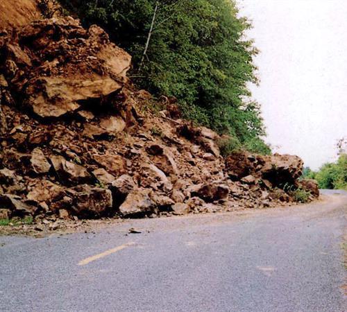 Humboldt County roads, which serve rural communities near the epicenter, were damaged and blocked at numerous locations by landslides. However, maintenance crews were able to clear one lane on most of these roads within 2 or 3 hours of the earthquake. Click/tap the image to view the complete version. Photo credit: Oscar Huber. Source: CALIFORNIA GEOLOGY magazine, March-April 1992.
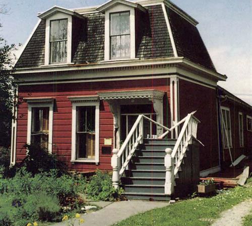 The front door was at the top of the stairs before this Ferndale house was shaken off its foundation. Click/tap the image to view the complete version. Photo credit: Kevin Bayliss. Source: CALIFORNIA GEOLOGY magazine, March-April 1992.
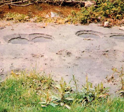 Small craters called sandblows provide evidence of liquefaction at the Salt River near Port Kenyon. These were about 12 inches (30 cm) in diameter. Similar sandblows were observed near the lower reaches of the Eel and Mattole rivers. Click/tap the image to view the complete version. Photo credit: Oscar Huber. Source: CALIFORNIA GEOLOGY magazine, March-April 1992.
The Tsunami
The 1992 Cape Mendocino earthquake produced a small tsunami that arrived at the coast within 20 minutes of the earthquake (Oppenheimer and others, 1993; Dengler and others, 1995). The tsunami was recorded on tide gages (or gauges) along the coast of California and Oregon. The National Oceanic and Atmospheric Administration (NOAA), which operates these tide gages, reported a 1.6 foot (0.5 m) tsunami at Crescent City (Mattison and others, 1992). At Eureka, wave heights were about 1 foot (0.3 m) (Oppenheimer and others, 1993; Dengler and others, 1995) and at Point Arena, about 0.6 feet (18 cm) (Mattison and others, 1992). The tsunami was even detected in Hawaii, measuring about 0.3 feet (9 cm) there (Mattison and others, 1992).
Learn more about your exposure to tsunami hazards at the California Tsunami Preparedness Guide, and explore our Tsunami Hazard Area Maps and Data.
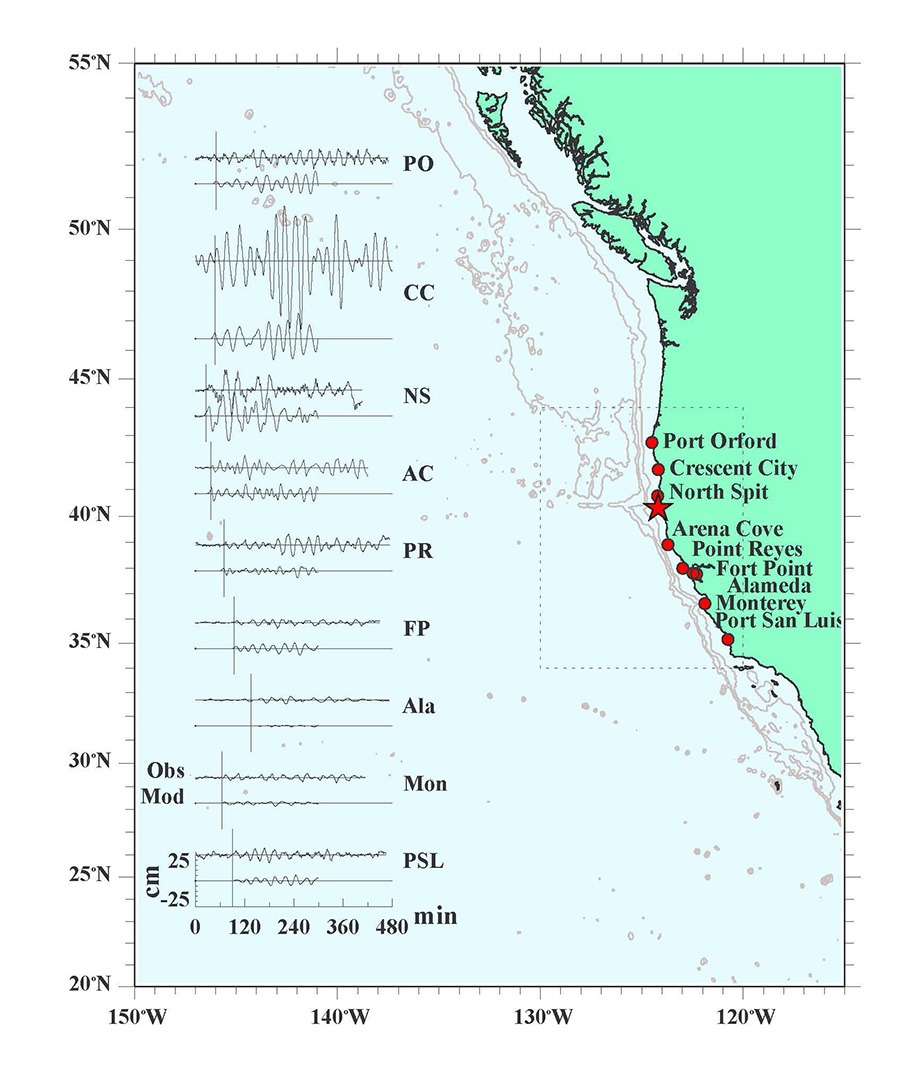 Marigrams (tide gage records) of the 1992 Cape Mendocino tsunami from NOAA tide gages in California and Oregon. The marigrams show that the tsunami lasted more than eight hours and that the first wave is not necessarily the largest wave. Click/tap the image to open a high-resolution version. Source: Oppenheimer et al., 1993.
The following map shows locations of tide gages that detected and recorded the tsunami. Explore the wave data by clicking/tapping on the triangle symbols. If you're on a smartphone, you should Open the map in a new window 
Significance and Lessons Learned
The 1992 Cape Mendocino earthquake was a significant event for several reasons:
- This was just five years after Dr. Brian Atwater wrote an article that provided the first evidence that the Cascadia subduction zone was capable of generating large magnitude earthquakes. The 1992 earthquake was on a fault related to the Cascadia megathrust subduction zone fault, so it reinforced the messages presented by Dr. Atwater in 1987.
- The important lessons from both the paper and the earthquake were that the Pacific Northwest is vulnerable to locally-produced earthquakes and tsunamis, and that people should prepare for the impact from this newly confirmed source of seismic hazard.
- This event inspired the formation of the National Tsunami Hazard Mitigation Program, which helps support state and local tsunami preparedness efforts. It is also largely responsible for the creation of the California Tsunami Program.
- From a policy perspective, the 1992 Cape Mendocino earthquake and tsunami supported the State Mining and Geology Board's earlier decision to include tsunami in the Seismic Hazards Mapping Act (SHMA). Under the SHMA, the CGS maps hazard zones and develops guidance for site-specific analysis and mitigation strategies.
References
Atwater, B.F., 1987, Evidence for Great Holocene Earthquakes Along the Outer Coast of Washington State in Nature, v. 236, no. 4804, p. 942-944.
Dengler, L.A., Moley, K., McPherson, R., Pasyanos, M., Dewey, J.W., and Murray, M., 1995, The September 1, 1994 Mendocino Fault Earthquake in California Geology, v. 48, no. 2, p. 43-53.
Mattison, E., Tabilio, L., and Walker, P., 1992, The Cape Mendocino Earthquakes in California Geology, v. 45, no. 2, p. 56-57.
Nelson, A.R., Asquith, A.C., Grant, W.C., 2004, Great Earthquakes and Tsunamis of the Past 2000 Years at the Salmon River Estuary, Central Oregon Coast, USA in BSSA, v. 94, no. 4, p. 1276-1292.
Oppenheimer, D., Beroza, G., Carver, G., Dengler, L., Eaton, J., Gee, L., Gonzalez, F., Jayko, A., Ki., W.H., Lisowski, M., Magee, M., Marshall, G., Murray, M., McPherson, R., Romanowicz, B., Satake, K., Simpson, R., Somerville, P., Stein, R., and Valentine, D., The Cape Mendocino, California, Earthquakes of April, 1992: Subduction at the Triple Junction in Science, v. 261, no. 5120, p. 433-438.
Savage, J.C., 1983, A Dislocation Model of Strain Accumulation and Release at a Subduction Zone in JGR, v. 88, no. B6, p. 4984-4996.
Web page by:
California Geological Survey - Seismic Hazards Program
Last modified: April 24, 2022
