 |
Estimation of Future Earthquake Losses in California
B. Rowshandel, M. Reichle, C. Wills, T. Cao, M. Petersen(*), D. Branum, and J. Davis
California Geological Survey
Executive Summary
Using the latest information on earthquake hazard in California and the publicly available demographic data, we have made estimations of expected future earthquake economic losses in the State. The estimates presented in this paper are for two categories: scenario earthquake loss, and annualized earthquake loss.
For scenario earthquake loss, we quantified the damage and loss expected in ten counties in the San Francisco Bay Area (SFBA) and in ten counties in Southern California, due to possible earthquakes on known faults in the two regions. To accomplish this task, we used scenario ground motions, or shake-maps of 50 potential earthquakes published by the United States Geological Survey (USGS). Of these 50 scenario shake-maps, 34 represent the expected ground motion hazard in the SFBA counties and 16 represent the expected ground motion hazard in the southern region. For annualized earthquake loss, we estimated the overall long-term damage and loss using the Probabilistic Seismic Hazard Analysis (PSHA) maps for the State of California, prepared and published by the California Geological Survey (CGS) and the USGS. These PSHA maps show the expected ground motions of specified annual chance of occurrence at any location within the State. The effect on ground motions on the soils at the site are taken into account for both the shake-maps and the PSHA maps, through the use of appropriate ground motion attenuation relations and soil correction factors. Liquefaction effect was taken into account for the annualized loss study, but not for the scenario loss study. Due to the non-existent or incomplete data on other earthquake hazards and effects, including ground rupture, landslide and fire, these potential hazards were not considered in either the study of scenario earthquake loss or the annualized earthquake loss.
 We used the latest version of the HAZUS software package, Service Release 2 (SR2) for the estimation of the damage and economic loss. The earthquake hazard data, obtained from the scenario shake-maps or the PSHA maps, and the liquefaction data (for the case of annualized loss) were then analyzed and supplied into the HAZUS package. HAZUS-SR2 default data was used for the information on the built environment and the demographics. This information in HAZUS-SR2 is, for the most part, derived from 1990 national census data. We used the latest version of the HAZUS software package, Service Release 2 (SR2) for the estimation of the damage and economic loss. The earthquake hazard data, obtained from the scenario shake-maps or the PSHA maps, and the liquefaction data (for the case of annualized loss) were then analyzed and supplied into the HAZUS package. HAZUS-SR2 default data was used for the information on the built environment and the demographics. This information in HAZUS-SR2 is, for the most part, derived from 1990 national census data.
The estimates presented in this paper are limited to ground motion-induced losses to buildings only. In other words, the losses to other elements of the built environment, such as transportation, lifeline and communication facilities are not reported here. Furthermore, the losses reported in this paper are only the direct economic losses due to building damage, which consist of capital stock loss and income loss. Indirect economic losses, representing the losses due to various forms of post-earthquake socioeconomic disruptions (such as employment and income, insurance and financial aids, construction, production and import-export of goods and services) are not included in the estimates reported. This is because of the higher level of uncertainty associated with the indirect losses, as compared to the direct losses. Therefore, it is expected that once the indirect building economic losses, the economic losses to non-building facilities, and the contributions of all earthquake hazards are taken into account, the estimated economic losses would be several times the numbers presented in this paper.
We present the estimated losses in three forms: losses in dollars for individual counties, losses in dollars for individual census tracts, and Loss Ratios (LR) - the loss as a percentage of the building replacement value. For illustration and as sample cases, the results for three scenario earthquakes in the SFBA and for three scenario earthquakes in Southern California are presented in tabular and graphical form. The results of all 50 scenarios are also summarized in this paper. Detailed results for all scenario earthquakes and for the State-wide annual losses are placed on the CGS website (bottom of this page).
Among the 34 scenario earthquakes of the SFBA, a repeat of the1906 earthquake results in the largest economic loss for the ten SFBA counties. It would rupture four segments of the San Andreas fault and would cause approximately $54 billion economic loss due to building damage. A number of other earthquakes on the San Andreas fault, rupturing different combinations of these four segments are also feasible. Should one occur, it would result in an estimated loss ranging from a few billion dollars to $50 billion. Other potentially damaging earthquakes in the SFBA are: a magnitude 6.9 event rupturing the entire Hayward fault causing $23 billion in losses; and a magnitude 7.3 earthquake rupturing the entire Hayward fault and the Rodgers Creek fault causing $34 billion in losses.
 For the ten-counties in Southern California, the most damaging potential earthquake for which a scenario has been computed turns out to be a magnitude 7.1 event on the Puente Hills fault, which would bring an estimated loss of $69 billion. Another major potential, damaging earthquake would be a magnitude 6.9 event on the Newport-Inglewood fault, resulting in about $49 billion expected loss. Other significant potential, damaging earthquakes are a magnitude 7.1 event on Palos Verdes fault, a magnitude 6.8 event on Whittier fault, and a magnitude 6.7 event on Verdugo fault with $30 billion, $29 billion, and $24 billion expected losses, respectively. For the ten-counties in Southern California, the most damaging potential earthquake for which a scenario has been computed turns out to be a magnitude 7.1 event on the Puente Hills fault, which would bring an estimated loss of $69 billion. Another major potential, damaging earthquake would be a magnitude 6.9 event on the Newport-Inglewood fault, resulting in about $49 billion expected loss. Other significant potential, damaging earthquakes are a magnitude 7.1 event on Palos Verdes fault, a magnitude 6.8 event on Whittier fault, and a magnitude 6.7 event on Verdugo fault with $30 billion, $29 billion, and $24 billion expected losses, respectively.
In order to take into consideration the effect of the building inventory value, scenario losses were computed in terms of the LR. This is simply the ratio of the expected loss to the dollar value of the building, expressed as percentage in this paper. Since it is normalized by the building replacement value, LR can be meaningfully used to compare the relative risk in different geographical areas. In terms of this parameter, the results indicate that a large part of the area affected by scenario earthquakes undergo an LR of a few percent. However, the zones neighboring faults experience loss ratios exceeding 20 percent. The extent and the distribution of large LR zones around faults vary from event to event. The LR results for the six scenario earthquakes presented in this paper are sown in graphical form. Loss ratio maps for all scenario earthquakes can be seen on the CGS website.
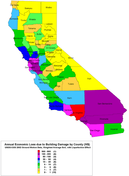
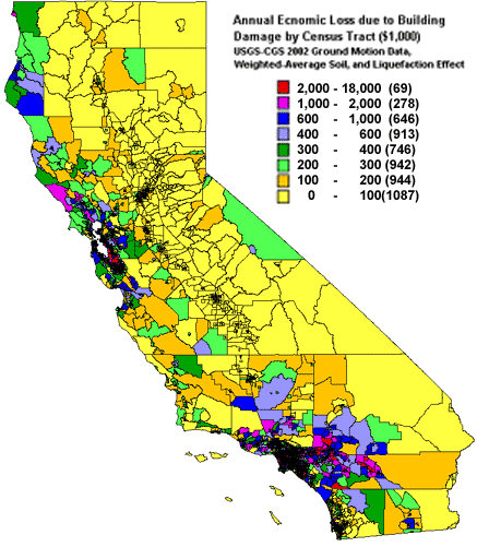
The second set of results we present in this paper are our estimates of the annualized direct economic losses due to building damage for the entire State. Annualized losses represent the long term, average losses due to potential ground motion hazards of all expected earthquakes in the region. These estimates are based on the latest CGS-USGS PSHA maps, the National Earthquake Hazard Reduction Program (NEHRP) soil correction factors, and including the liquefaction effects. Results are presented in terms of total annual loss, annual per-capita loss, and annual loss ratio (ALR).
The estimated annual economic loss due to building damage for the State is $2.2 billion. Of this, approximately 5% ($100 million) is due to the liquefaction effect. However, since the existing data on liquefaction is not complete, the estimated loss and particularly this percentage could be significantly higher. Specifically, for many areas in the SFBA this effect exceeds 20%. The areas of highest expected annual loss are the Los Angeles area in the south and the SFBA in the north.
Reported losses due to major earthquakes in California since 1971.
| Earthquake |
Date |
Magnitude |
Total Loss(1) |
| San Fernando |
February 9, 1971 |
6.6 |
2,200(2) |
| Imperial Valley |
October 15, 1979 |
6.5 |
70(2) |
| Coalinga |
May 2, 1983 |
6.4 |
18(2) |
| Whittier Narrows |
October 1, 1987 |
6.0 |
522(3) |
| Loma Prieta |
October 17, 1989 |
6.9 |
10,000(4) |
| Petrolia |
April 25, 1992 |
7.2 |
80(3) |
| Landers |
June 28, 1992 |
7.3 |
120(3) |
| Northridge |
January 17, 1994 |
6.7 |
46,000(5) |
| Hector Mine |
October 16, 1999 |
7.1 |
“Minor” |
(1)Estimates are in (2000) millions dollars
(2)Estimate is from FEMA (1997)
(3)Estimate is from U.S. Office of Technology Assessment
(4)Estimate is from NRC (1994)
(5)Estimate is from California Governor's Office of Emergency Services |
In terms of the total annual loss, the county of Los Angeles exceeds the rest of the counties, with an estimated expected annual loss of approximately $740 million - about one-third of the state-wide estimate. The counties with the next largest estimated annual losses are Alameda with about $200 million, and Orange, San Bernardino and San Francisco, with estimated losses in the range of $140-155 million each.
We have also considered the role of population density in the distribution of expected annual losses by computing and plotting the per-capita loss. Based on our results, the three counties with the highest expected annual per-capita losses are San Francisco with $195, Alameda with $155 and San Mateo with $120. The state-wide average for the expected per-capita annual loss is $104.
In terms of ALR, the estimated state-wide average is 0.15%. This means that, state-wide and on average, earthquake ground motions are expected to cause damage to buildings equal to 0.15% of their dollar values, each year. In terms of this indicator, Alameda with ALR=0.264% followed by San Francisco with ALR=0.240% are the two highly impacted counties within the State.
There are a large number of sources of uncertainty in earthquake loss estimations. Uncertainties are associated with the methodologies, assumptions and data-bases used to estimate the ground motion, modeling of building responses and correlating expected losses to the estimated damages. Some of the most significant sources of such uncertainties in earthquake loss estimation studies in general and the study summarized here in particular are discussed. The effects of such uncertainties on the estimated losses and their implications in the use of such estimates for risk reduction and response planning are pointed out.
The estimates made in this study have been compared with estimates made by other studies, using other loss estimation software and building inventory and demographic data. It is found that, the results of this study are in general agreement with the findings of other studies.
(*) Now at the USGS, Denver, CO.
PDFs of scenario results for Northern and Southern California
(Requires Acrobat Reader to view. Click here to download)
Download:
Scenario Earthquakes and associated losses for ten-county Northern California.
Click on Scenario name to download/view associated figures(PDF).
Scenario Earthquake
(USGS Scenario Name) |
M |
Estimated Building Damage
Economic Loss ($M) |
San Andreas Fault:
Repeat of the 1906 San Francisco Earthquake (SAS+SAP+SAN+SAO) |
7.9 |
54,000 |
San Andreas Fault:
Santa Cruz + Peninsula + North Coast segments (SAS+SAP+SAN) |
7.8 |
50,000 |
San Andreas Fault:
Peninsula + North Coast + Offshore segments (SAP+SAN+SAO) |
7.8 |
47,000 |
San Andreas Fault:
Santa Cruz + Peninsula segments (SAS+SAP) |
7.4 |
30,000 |
San Andreas Fault:
Santa Cruz segment (SAS) |
7.0 |
5,900 |
San Andreas Fault:
Peninsula segment (SAP) |
7.2 |
24,000 |
San Andreas Fault:
North Coast + Offshore (SAN+SAO) |
7.7 |
16,000 |
San Andreas Fault:
North Coast segment (SAN) |
7.5 |
15,000 |
San Andreas Fault:
Offshore segment (SAO) |
7.3 |
Shake-Map Not Available |
Southern Hayward:
Repeat of the 1868 Earthquake (HS) |
6.7 |
15,000 |
| Northern Hayward (HN) |
6.5 |
9,000 |
| Southern Hayward + Northern Hayward (HS+HN) |
6.9 |
23,000 |
| Rodgers Creek (RC) |
7.0 |
8,000 |
| Northern Hayward + Rodgers Creek (HN+RC) |
7.1 |
20,000 |
| Southern Hayward + Northern Hayward + Rodgers Creek (HS+HN+RC) |
7.3 |
34,000 |
| Southern Calaveras (CS) |
5.8 |
100 |
| Central Calaveras (CC) |
6.2 |
2,700 |
| Southern Calaveras + Central Calaveras (CS+CC) |
6.4 |
3,200 |
| Northern Calaveras (CN) |
6.8 |
10,000 |
| Central Calaveras + Northern Calaveras (CC+CN) |
6.9 |
12,600 |
| Southern + Central + Northern Calaveras (CS+CC+CN) |
6.9 |
13,000 |
| Concord (CON) |
6.2 |
2,800 |
| Southern Green Valley (GVS) |
6.2 |
2,100 |
| Concord + Southern Green Valley (CON+GVS) |
6.6 |
7,000 |
| Northern Green Valley (GVN) |
6.0 |
600 |
| Southern + Northern Green Valley (GVS+GVN) |
6.5 |
3,200 |
| Concord + Southern + Northern Green Valley (CON+GVS+GVN) |
6.7 |
6,800 |
| Southern Greenville (GS) |
6.6 |
1,800 |
| Northern Greenville (GN) |
6.7 |
3,200 |
| Southern + Northern Greenville (GS+GN) |
6.9 |
5,000 |
| Southern San Gregorio (SGS) |
7.0 |
300 |
| Northern San Gregorio (SGN) |
7.2 |
13,000 |
| Southern + Northern San Gregorio (SGS+SGN) |
7.4 |
15,000 |
| Mount Diablo thrust (MTD) |
6.7 |
7,000 |
Scenario Earthquakes and associated losses for ten-county Southern California.
Click on Scenario name to download/view associated figures.
Scenario Earthquake
(USGS Scenario Name) |
M |
Estimated Building Damage
Economic Loss ($M) |
| Puente Hills |
7.1 |
69,000 |
| Newport-Inglewood |
6.9 |
49,000 |
| Palos Verdes |
7.1 |
30,000 |
| Whittier Fault |
6.8 |
29,000 |
| Verdugo Fault |
6.7 |
24,000 |
San Andreas Fault:
Southern Rupture |
7.4 |
18,000 |
San Andreas Fault:
Repeat of the 1857 Earthquake |
7.8 |
17,000 |
| Santa Monica |
6.6 |
17,000 |
| Raymond Fault |
6.5 |
17,000 |
| San Joaquin Hills |
6.6 |
15,000 |
| Rose Canyon |
6.9 |
14,000 |
| San Jacinto |
6.7 |
7,000 |
| North Channel Slope |
7.4 |
4,000 |
| Elsinore Fault |
6.8 |
4,000 |
| Coachella Valley |
7.1 |
3,000 |
| Imperial |
7.0 |
1,000 |
|
