To memorialize this important event in California seismology, we've reproduced the following series of articles from CALIFORNIA GEOLOGY™ magazine*
*Updated and edited June 2022 by Timothy Dawson, Cynthia Pridmore, Brian Olson, Kate Thomas, and Robert Wurgler
Download the original articles as they appeared in CALIFORNIA GEOLOGY™ magazine
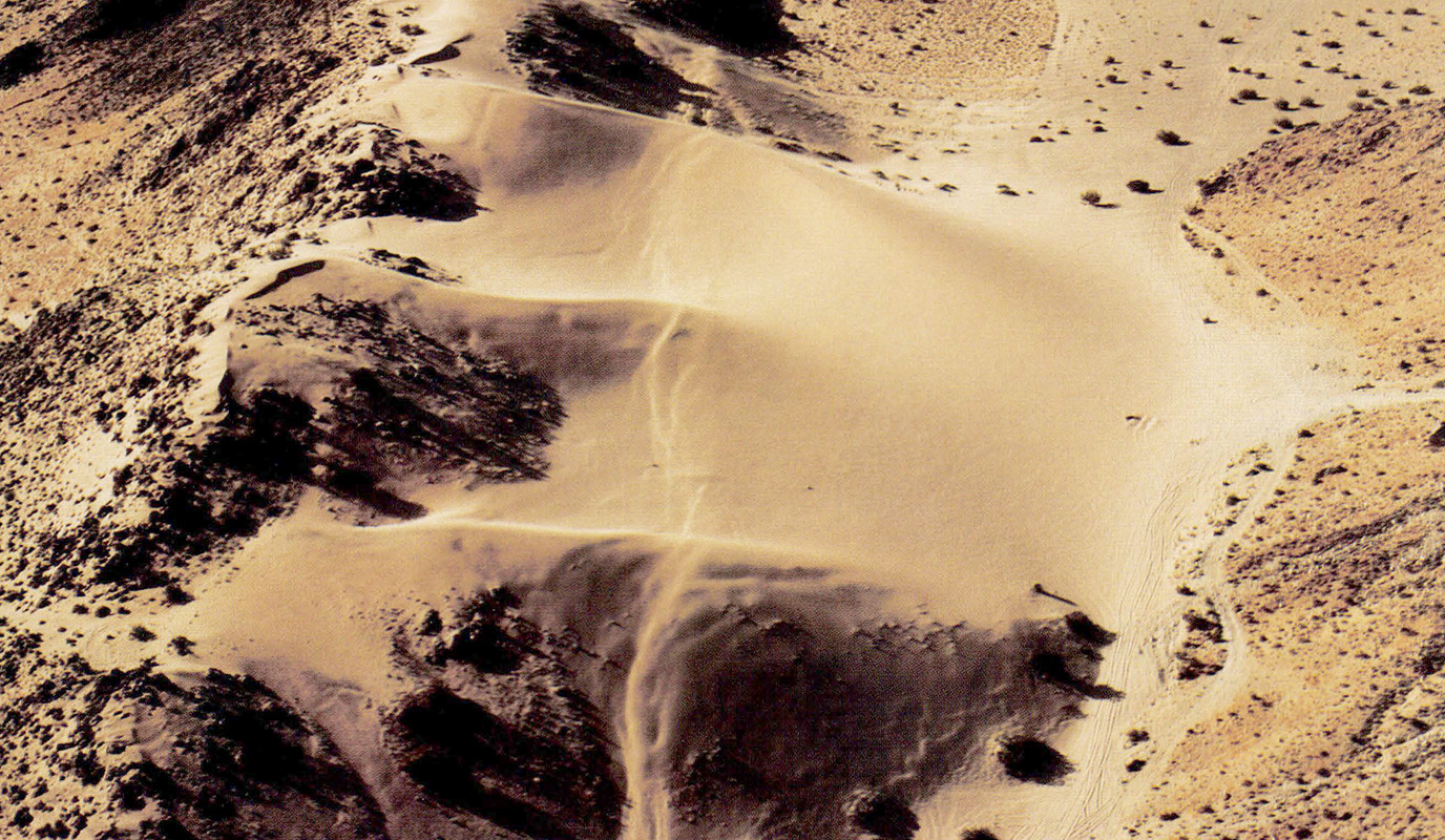
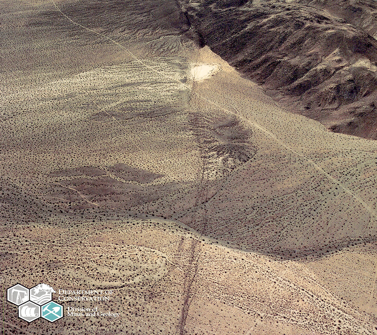 Cover photo: A complex zone of surface rupture along the Emerson Fault extends from bottom center of photo to just beyond small playa (sag pond) at top center of photo. The uplifted older alluvial tan deposits immediately left of the playa appear to be offset right-laterally about 1,000 feet (300m). Light-colored, narrow lines are dirt bike and jeep trails. Beyond the playa, the rupture zone extends southeastward into the mountain range. Click/tap the image to open a larger version in a new window. Photo by I.K. Curtis Services, Inc., July 3, 1992.
Contents
Overview
 Main trace of Johnson Valley fault at the Country Gospel Church in the Flamingo Heights area. Zone of fracturing is approximately 30 feet (10 m) wide. More than 6 feet (2m) of right lateral displacement was measured at the parking spaces (upper left). Click/tap the image to open a larger version in a new window. Photo by Jack McMillan.
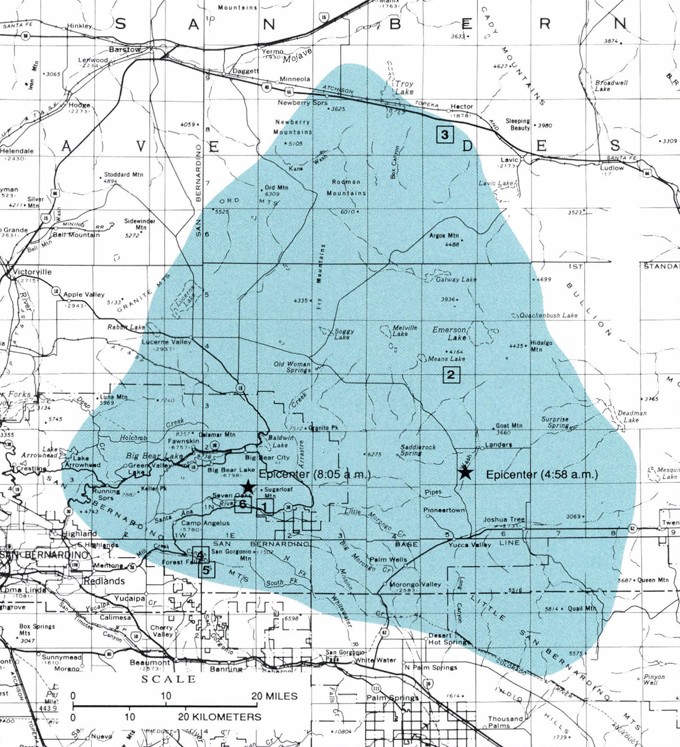
The Landers earthquake occurred June 28, 1992 along a near vertical, north-northwest trending, right-lateral, strike-slip fault. Faulting propagated mostly northward from the epicenter, generating about 50 miles (80 km) of surface fault rupture on four previously mapped faults: the Johnson Valley, Homestead Valley, Emerson, and Camp Rock faults (see Figure A-1 in next section). These faults had been zoned over most of their extent by the CGS Alquist-Priolo program and thus had been recognized as being capable of inflicting damage by fault rupture. Rupture also occurred along minor faults near the town of Yucca Valley, and in step-over areas between the zoned faults.
Minor sympathetic movements were triggered on nearby faults including the Pisgah, Calico, and Galway Lake faults. Displacements varied greatly along the fault rupture. Apparent vertical displacement of up to 4 feet (1.2 m) was observed on the Emerson fault. A maximum right-lateral displacement of about 20 feet (6 m), one of the largest surface fault displacements observed historically in California, was measured along the Emerson fault. This illustrates that some of the right-lateral slip between the Pacific and North American plates that is not occurring on the San Andreas fault is occurring on faults in the Mojave Desert.
 Surface rupture on Kickapoo Fault in Homestead Valley. Click/tap the image to open a larger version in a new window. Photo by William A. Bryant.
Historical earthquake activity in the area includes the 1975 ML 5.0 Galway Lake earthquake (see CALIFORNIA GEOLOGY, October 1975) and the 1979 ML 5.3 Homestead Valley earthquake (see CALIFORNIA GEOLOGY, March 1980), both of which resulted in surface fault rupture. Faults that ruptured during the 1975 and 1979 events ruptured again during the Landers event.
The maximum Modified Mercalli Intensity (MMI) was IX at Landers.
 Wide zone of deformation along the Emerson fault in the area of maximum right-lateral offset (west of Galway Lake). Click/tap the image to open a larger version in a new window. Photo by William A. Bryant.
The Big Bear earthquake occurred at a depth of 6 miles (10 km) along a subsurface northeast trending, left-lateral, strike-slip fault. No surface fault rupture was found.
Approximately 500 aftershocks of ML 3.0 or greater occurred during the month following the Landers and Big Bear earthquakes. These include related seismicity to the northeast near the Pisgah fault and to the northwest near the Calico fault.
The earthquakes occurred in sparsely populated areas, so damage and casualty totals were low. The Landers earthquake caused major damage to buildings and to the lifeline infrastructure in the communities of Landers and Yucca Valley. Strong ground-shaking, landslides, and rockfalls caused by the Big Bear earthquake damaged buildings and roadways in the Big Bear Lake area. There were 377 minor and 25 major injuries and one fatality from the June 28 earthquakes.
 Vertical scarp of the Emerson fault, west side down, near the zone of maximum fault displacement. Although there is a vertical component of displacement along this portion of the fault, some of the vertical separation in this photo can be attributed to right-lateral juxtaposition of a ridge and a swale. Click/tap the image to open a larger version in a new window. Photo by Tim McCrink.
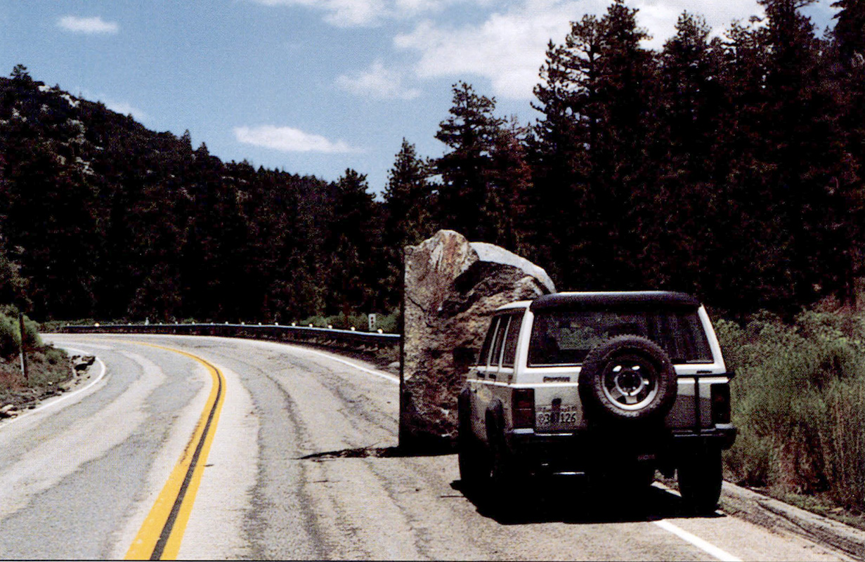
 This boulder rolled down the steep south side of Mill Creek Canyon into the back yard of a home in the community of Forest Falls. It is one of the larger boulders set in motion by the MS6.6 Big Bear earthquake and its aftershocks. Click/tap the image to open a larger version in a new window. Photo by Tim McCrink.
The Landers-Big Bear Earthquake Sequence and its Felt Effects
By TOUSSON R. TOPPOZADA, Seismologist; with contributions from Dr. Egill Hauksson, Dr. Hiroo Kanamori, Katrin Douglass, Lindie Brewer, Glen Reagor, Carl Stover, Michael Reichle, Claudia Hallstrom, and Virginia Williams.
Contents
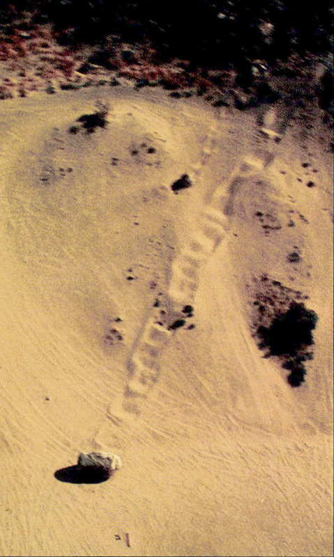
 Unusual ruptures in sand dunes along northern segment of Homestead Valley Fault had about 10 feet (3 m) of right-lateral displacement. Note the left-stepping pattern and narrowness of the fault zone. Click/tap the image to open a larger version in a new window. Photo by W.A. Bryant.
Introduction
In 1992 a remarkable sequence of moderate to major earthquakes occurred in the Mojave Desert, 30 to 50 miles (50 to 80 km) east of San Bernardino. This area is north and east of the historically active San Andreas Fault and south of the Holocene-active Garlock Fault.
Table 1 lists the known earthquakes of magnitude 5.0 or greater (M≥5> that occurred before June 28, 1992, in the area surrounding Landers. Figure A-1 shows the locations of events in the table. Most of the pre-1975 activity appears to be related to the San Andreas Fault Zone. Surface faulting occurred in the 1975 and 1979 earthquakes and was reactivated as part of the 1992 Landers faulting. The most recent earthquake of M≥5 related to the San Andreas Fault occurred near Palm Springs in 1986.
TABLE 1: M≥5 earthquakes (mainshocks only) in the area of Figure A-1.
| Big Bear |
MS6.6 |
1992 June 28 |
| Landers |
MS7.5 |
1992 June 28 |
| Joshua Tree |
MS6.3 |
1992 April 22 |
| North Palm Springs |
M5.6 |
1986 July 8 |
| Homestead Valley |
M5.3 |
1979 March 15 |
| Galway Lake |
M5.0 |
1975 May 31 |
| Desert Hot Springs |
M6.5 |
1948 Dec. 4 |
| Morongo Valley |
M5.5 |
1947 July 24 |
| Manix |
M6.2 |
1947 April 10 |
| Ludlow-Bagdad |
M5.6 |
1946 July 18 |
| San Gorgonio Pass |
M5.3 |
1944 June 12 |
| Morongo Valley |
M5.4 |
1940 May 17 |
| San Gorgonio Mountain |
M5.1 |
1935 Oct. 24 |
| San Bernardino-Loma Linda |
M6.2 |
1923 July 23 |
| Eastern San Bernardino Mountains |
M~5.5-6 |
1907 Sep. 19 |
| Lytle Creek-San Bernardino Mountains |
M~6.5 |
1899 July 22 |
| Morongo Valley |
M~5.5 |
1889 Feb. 6 |
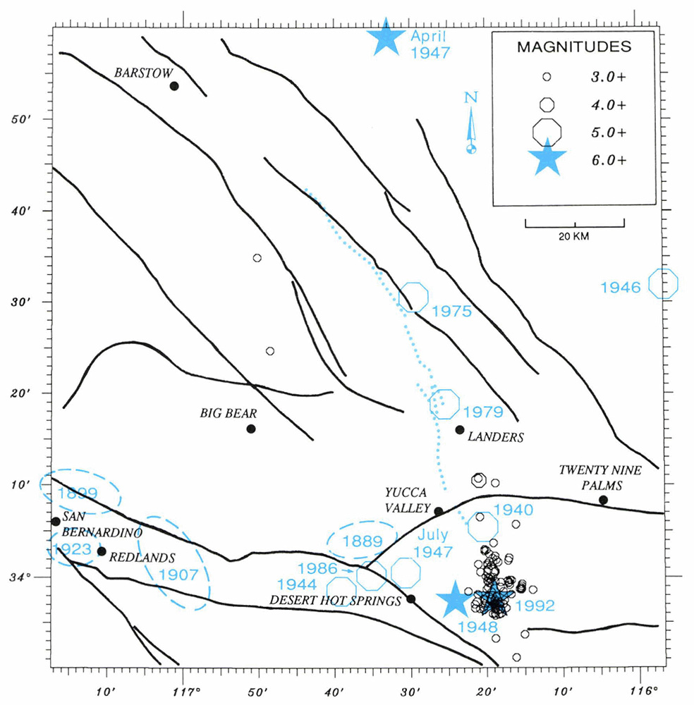 Figure A-1. Seismicity preceding the Landers earthquake. Epicenters of M≥5.0 earthquakes are blue. Approximate locations of pre-instrument earthquakes (M5.5-6.5) are outlined with dashes. Aftershocks of M≥3.0 for the April 22, 1992 Joshua Tree earthquake, through June 27, 1992 are black. The mainshock is near the south end of the aftershocks. The faulting from the then-impending June 28 Landers earthquake is dotted. Click/tap the image to open a larger version in a new window. Joshua Tree data courtesy of CIT and USGS.
Earthquake Sequence
Joshua Tree Earthquake
On April 22, 1992, the Joshua Tree earthquake (MS6.3) occurred 11 miles (18 km) east of Desert Hot Springs, at a depth of 7 miles (12 km). Although this event occurred 2 months before the Landers and Big Bear earthquakes, it is now considered to be the start of a major earthquake sequence that peaked with the two June 28 events. No primary surface faulting was observed from this event, but subsurface faulting propagated northward 12 miles (19 km) to the town of Joshua Tree, where it caused shaking damage. Seismographic first motions indicated right-lateral strike-slip on a north-northwest-trending vertical fault. Aftershocks extended northward across the Holocene-active Pinto Mountain Fault as shown in Figure A-1. Minor triggered slip (0.24 inches [6 mm] right lateral, 0.16 inches [4 mm] vertical, east side up) was observed 3.5 miles (5.6 km) west-northwest of the main shock on a less than 1 mile long, discontinuous segment of a north-trending, west-dipping fault.
Landers Earthquake
On June 28 at 4:57a.m. the largest earthquake (MS7.5) in California since the 1952 Kern County MS7.7 earthquake occurred near Landers and the northern end of the Joshua Tree aftershock zone. The Landers rupture propagated northward on the Johnson Valley Fault, and then stepped to the east to the Homestead Valley, Emerson, and Camp Rock faults, with the strike of each successive fault trending farther to the west, (Figure A-2). The fault rupture was mapped by California Institute of Technology (CIT), the U.S. Geological Survey (USGS), and the California Geological Survey.
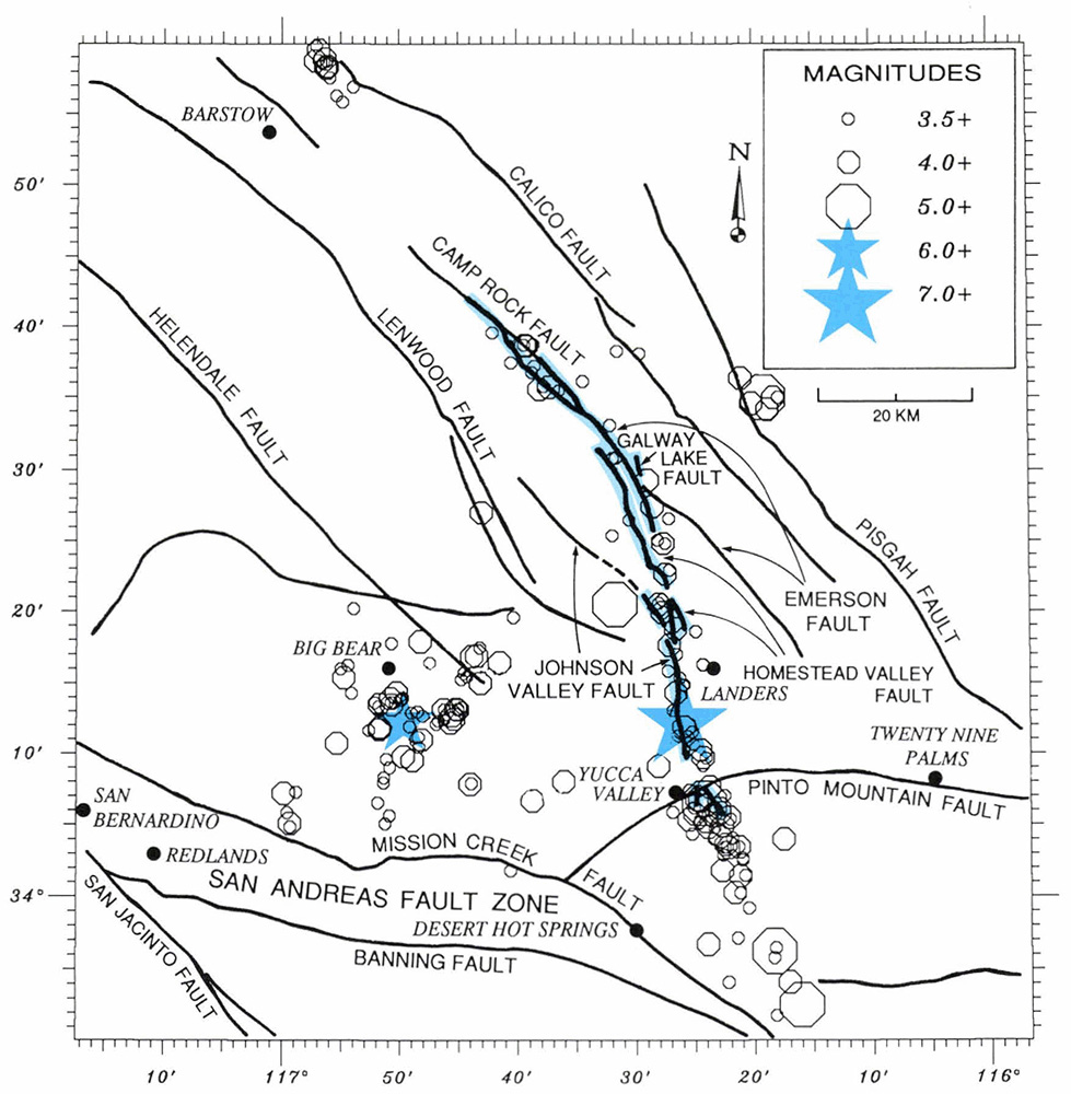 Figure A-2. Aftershocks of M≥3.5 for the June 28,1992 Landers and Big Bear earthquakes through September 10, 1992. Blue shading has been added to show surface faulting. Inversion of teleseismic P and S waves revealed two strike-slip sub-events of 6- and 8-second duration and about 10 seconds apart. The strike of the first event was 1 degree west of north, and of the second event 27 degrees west of north, as shown by the distribution of aftershocks and faulting. Click/tap the image to open a larger version in a new window. Courtesy of CIT and USGS.
Kanamori and others (1992) derived the distribution of slip along the fault by inverting seismic waveforms and found it to be roughly comparable to the slip observed in the field. Large slip began about 2 miles (3 km) north of the epicenter on the Johnson Valley and southern Homestead Valley faults and died out about 11 miles (18 km) north of the epicenter (Figure A-3). It resumed on the Homestead Valley Fault about 17 miles (27 km) north of the epicenter and continued on the Emerson (where maximum slip was observed in the field) and Camp Rock faults, extending to approximately 37 miles (60 km) north of the epicenter. These two regions of large slip (Figure A-3), indicate the Landers earthquake consisted of two sub-events about 19 miles (30 km) apart, with the second event, to the north, being twice as large as the first.
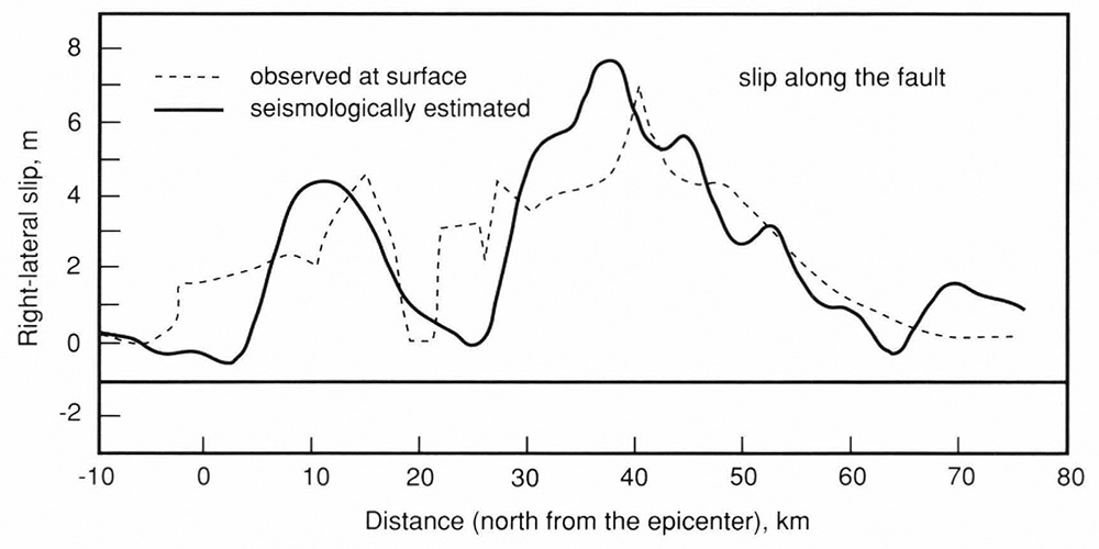 Figure A-3. Slip distribution along the fault estimated from TERRAscope broadband records (solid line). Surface displacements observed in the field are shown by the dashed line. Click/tap the image to open a larger version in a new window. From Kanamori and others, 1992.
Inversion of teleseismic P and S waves revealed two strike-slip sub-events of 6- and 8-second duration and about 10 seconds apart. The strike of the first event is 1 degree west of north, and of the second event 27 degrees west of north. The change in strike from the first to the second event is consistent with the distribution of aftershocks and the faulting shown in Figure A-2.
Big Bear Earthquake
The Big Bear earthquake (MS6.6) occurred at 8:05 a.m., 3 hours after the Landers event, along a northeast-trending left-lateral strike-slip fault at a focal depth of approximately 6 miles (10 km). No surface faulting was found for this earthquake.
Aftershocks
The aftershock zones of the two June 1992 earthquakes formed a triangle about 43 miles (70 km) on a side, with the Landers zone on the east, the Big Bear zone on the west, and the San Andreas Fault Zone (Mission Creek and Banning strands) on the south (Figure A-2).
Aftershocks ≥ M3.5 that occurred between June 28 to September 10 are shown in Figure A-2, and have a distribution similar to the M≥3.0 aftershocks that occurred from June 28 to July 27. Both aftershock maps show that surface faulting on the Camp Rock Fault extends 3 to 6 miles (5 to 10 km) farther northwest than the main aftershock zone. This suggests that the northwest end of the surface faulting is shallow and may not extend to seismogenic (earthquake-generating) depth. Also, both maps show a persistent cluster of earthquakes near Barstow that is separated from the main aftershock zone by a 22-mile (35-km) gap.
Aftershocks follow the trend of the surface faulting, as seen in Figure A-2. The epicenters of the Landers aftershocks form a continuous north- to northwest-trending zone from the San Andreas Fault to the Camp Rock Fault. They extended across the Holocene-active Pinto Mountain Fault and south of the surface fault rupture as far as the San Andreas Fault. The aftershocks of the Big Bear earthquake trended southwest as far as the San Andreas Fault, where a M4 earthquake occurred near Yucaipa, with mechanism parallel to the San Andreas Fault.
Preliminary Isoseismal Map of Landers Earthquake
Modified Mercalli Intensity (MMI) values were obtained mainly from the National Earthquake Information Center-USGS (NEIC-USGS). CGS staff assigned additional intensities by interpreting newspaper reports of occurrence and severity of damage for several towns that were not listed by NEIC-USGS. The highest predominant intensity values were plotted on a map and contoured to show the areas shaken at MMI's VI, VII, and VIII (Figure A-4). This is a preliminary map, and may differ in detail from subsequent maps published with more complete intensity information. It is possible that the preliminary map includes the effects of the Big Bear earthquake, which would result in higher intensities, particularly in the Big Bear to San Bernardino area.
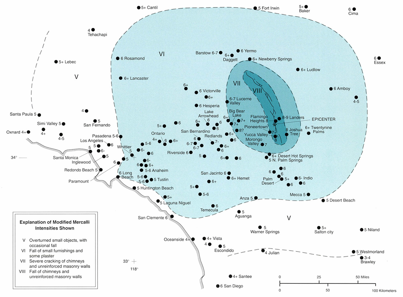 Figure A-4. Preliminary Modified Mercalli Intensity map of the Landers earthquake. Click/tap the image to open a larger version in a new window. Based largely on information from NEIC-USGS.
The MMI VII and VIII zones are poorly defined because of the sparsity of population around the fault area. Also, the MMI VII zone possibly includes some effects of the Big Bear earthquake. The MMI VI zone, where much of the damage was to contents of buildings, appears to be moderately well defined and extends from the Los Angeles Basin to the eastern Mojave Desert (Figure A-4). It covers about 18,100 square miles (47,000 km2). This is smaller than the 27,000 square miles (70,000 km2) for the MMI VI and greater area of the 1952 Kern County earthquake of MS7.7, but larger than the land area of 7,300 square miles (19,000 km2) for the MS7.1 Loma Prieta earthquake. Figure A-5 shows the MMI VI area for each of these earthquakes, and for the MS7.1 Imperial earthquake of 1941. Of these four important M>7 earthquakes, Loma Prieta was the most destructive, because the VII zone included much of the metropolitan San Francisco Bay area.
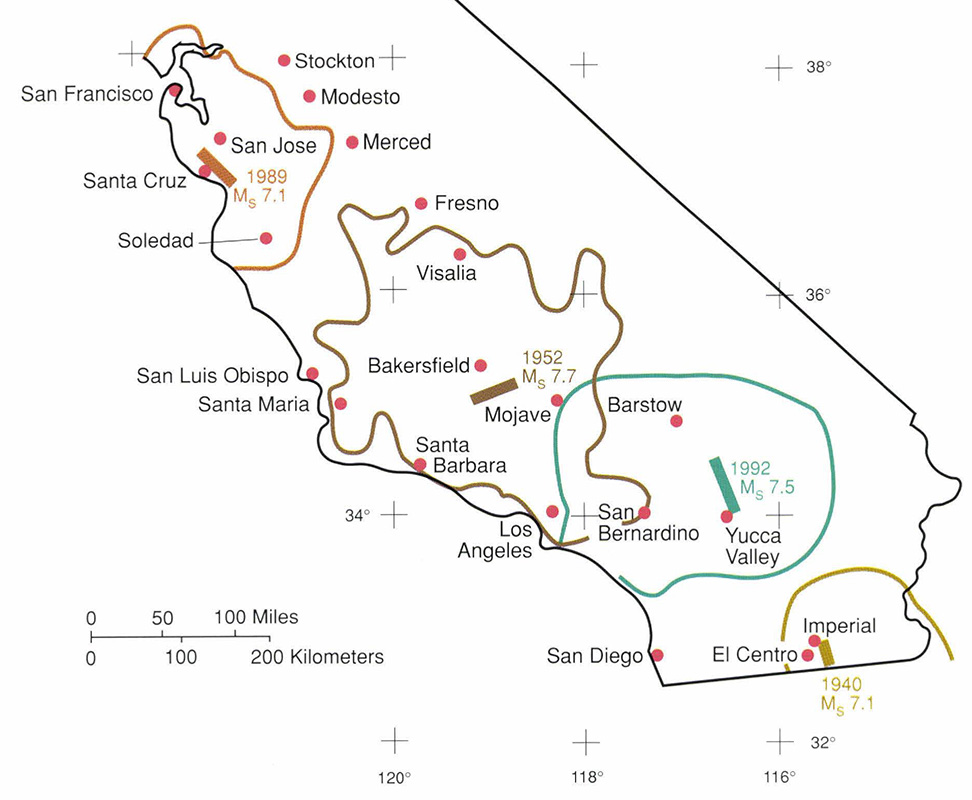 Figure A-5. The areas shaken at Modified Mercalli Intensity (MMI) VI and greater for the 1992 Landers, 1989 Loma Prieta, 1952 Kern County, and 1940 Imperial County earthquakes. The corresponding fault segments are indicated schematically by thick lines. Click/tap the image to open a larger version in a new window.
Casualties and Damage
The California Office of Emergency Services (OES) reported one death, 25 serious injuries, and 372 other injuries as a result of the earthquake series. In San Bernardino County, 77 homes were destroyed and 4,369 were damaged, with losses estimated to be $47.5 million. Twenty-seven businesses were destroyed or had major damage, and 139 others sustained lesser damage, resulting in losses estimated to be $17 million. Public sector damage (water, sewer, and public buildings) was estimated at $26.6 million. Damage estimates for Riverside County included 24 residences and seven businesses, totaling slightly less than $1 million.
Impact on Lifelines
Damage to water and gas systems and highways was limited to the epicentral region because faulting occurred in a desert area. The following lifeline information is mostly from the August 1992 Earthquake Engineering Research Institute report.
Water and Waste Water
Water distribution systems suffered damage to pipelines and storage tanks. Ground-water wells and storage tanks supply all the water in the Landers epicentral area. Water customers were without water for several hours to 2 weeks. Hundreds of water-line breaks were reported in the Landers area. Much of the pipeline damage occurred in the fault zone, where there were large displacements.
Damage to water systems was less severe in the Big Bear area. According to the director of Big Bear Lake Public Works, there were approximately 50 water pipe repairs made in 2 days. Water storage tanks appeared to be undamaged.
Waste water disposal in the Yucca Valley area is handled by private individual sewage disposal facilities. Concern about contamination from waste water led to the boiling of drinking water for 2 weeks, until both systems were inspected and repaired.
Power
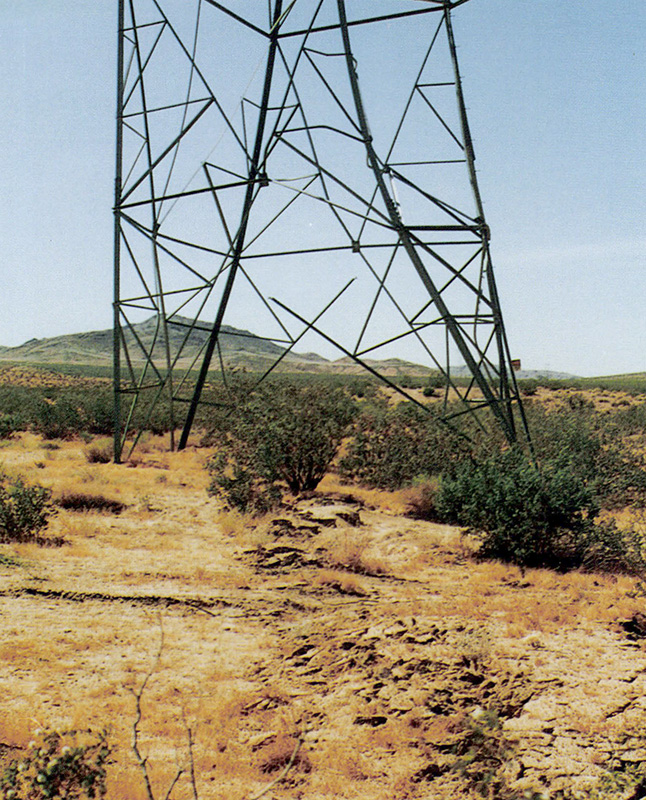 Powerline tower severely damaged by rupture on Emerson Fault where 11 feet (3.4 m) of right-lateral slip was measured. Rupture forms a relatively narrow mole track here but splays into a complex zone nearly 1,000 feet wide (300 m) 1 mile (1.6 km) to the northwest. Click/tap the image to open a larger version in a new window. Photo by A. G. Barrows.
The major electric power agency in and around Landers lost service to 550,000 customers due to localized damage within the distribution system. Most of the service was restored within 24 hours.
Localized failures caused loss of power for several hours to 5,000 customers in the Big Bear Lake area. In the Los Angeles area 51,000 customers lost power, again due to distribution system failures. Nearly all service was restored within 24 hours.
The high voltage power transmission and switching system performed well because of the distance between the fault trace and vulnerable switchyards. The Camp Rock-Emerson surface fault ruptured under a bolted steel frame 220 kV transmission tower, moving two of the legs approximately 9 feet (3 m) relative to the other two. This resulted in substantial deformation of the steel tower and failure of several braces, but no damage was sustained by the transmission lines or ceramic insulators.
Fuel
There was no damage to two high pressure gas transmission lines passing through the area, one a 6-inch (15-cm) line south of the primary rupture zone and the other a 30-inch (76-cm) line north of the primary rupture zone. There was some nonstructural damage to a compressor station on the 30-inch (76-cm) line.
No significant damage to the underground natural gas distribution system was observed in Yucca Valley or Joshua Tree.
Houses in Landers use propane gas from above-ground tanks. Some of these tanks slid and fell off their concrete pads, rupturing the attached piping. Unbraced hot water tanks toppled, breaking propane line connections in some cases. Fires resulted in several instances.
The natural gas system in Big Bear did not suffer any breaks in its main lines, although many gas connections were broken because houses shifted from their foundations. Some areas around Big Bear rely on propane tanks for fuel. Damage to unanchored tanks was similar to that in the Landers area.
Transportation and Communications
State Highway 247 (Old Woman Springs Road) was disrupted in ten locations and not fully restored until 8 days later. Other county and gravel roads in the area were similarly disrupted, but remained open to traffic as repairs were made. State Highway 38 to Big Bear Lake remained closed for 2 weeks because of rock slides. Restrictions to travel on Highway 247 south of Lucerne Valley were imposed to reduce congestion in the Big Bear area.
Operations at one military and three small civilian airports in the Yucca Valley area were not adversely affected by the earthquakes, despite minor cracking of runways and taxiways and some loss of power.
Telephone systems performed well, although service was affected by the usual post-earthquake high volume congestion. Reported damage included a downed overhead cable and a few tension failures in buried cable. Although there were some temporary disruptions immediately following the event, telephones were generally working throughout the epicentral region within a few hours. Sporadic local outages were reported for approximately 3 days following the earthquakes.
FM radio station KROR in Yucca Valley, which had emergency backup power, continued operations after the earthquakes, providing valuable (local emergency) public information. The radio station in Big Bear also remained in service.
Triggered or Stimulated Seismicity
Within minutes after the Landers earthquake, hundreds of small earthquakes (M<3) occurred in volcanic areas near Mammoth Lakes in central California and near Mount Shasta in northern California. Also, a swarm of earthquakes of M≤4.1 near Cedar in southwestern Utah began within an hour of the Landers earthquake.
The next day, a M5.6 earthquake struck near the Nevada-California border, 210 miles (340 km) north-northeast of Landers and 12 miles (19 km) east of Lathrop Wells. The event may be associated with the Rock Valley Fault System, just off the southern border of the Nevada Test Site. Damage to a Department of Energy unreinforced masonry office building included cracks in the outside walls, damage to interior steel frame doors, and broken glass. The building is about 6 miles (10 km) from a proposed underground radioactive waste site.
The western Mojave Desert also experienced an increase in seismic activity, including a M5.5 earthquake on July 11, 1992, near the junction of the Garlock and Sierra Nevada faults, 124 miles (200 km) northwest of Landers. Seismicity at several other sites as far away as Yellowstone National Park, 750 miles (1,200 km) from Landers, also increased markedly. The conventional wisdom that seismicity is triggered only within about one source dimension (50-mile [80-km] rupture for Landers) is being reevaluated, at least for MS≥7.5 earthquakes.
Surface Faulting Associated with the Landers Earthquake
By EARL W. HART, WILLIAM A. BRYANT, AND JEROME A. TREIMAN, Geologists.
Contents
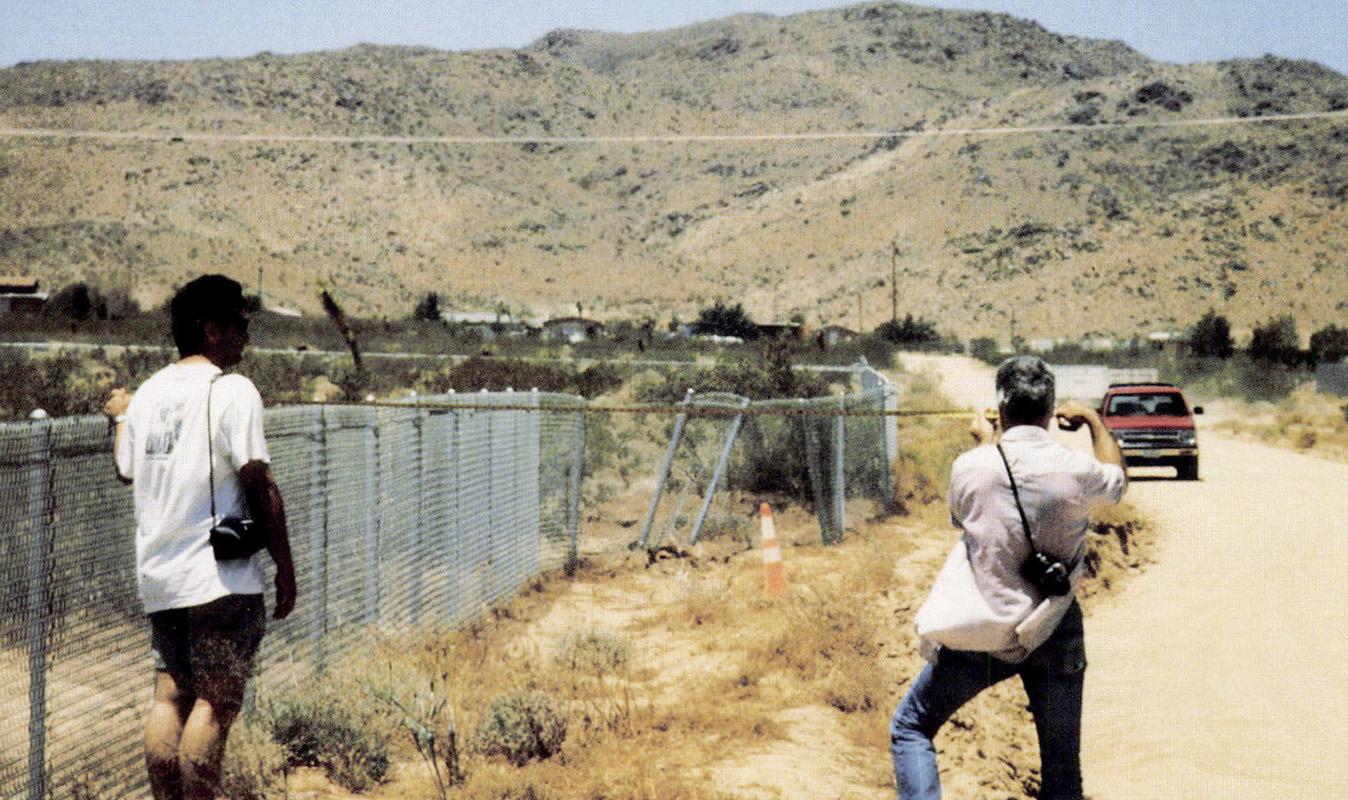 Geologists measuring 9.5 feet (2.9 m) of right-lateral offset of chain-link fence along Encantado Road west of Landers. Click/tap the image to open a larger version in a new window. Photo courtesy of Geomatrix Consultants.
Introduction
Surface fault rupture associated with the June 28, 1992 Landers earthquake occurred in San Bernardino County, from the vicinity of Yucca Valley to the Rodman Mountains, a distance of 53 miles (85 km). This was the largest fault-rupture event in California since the 1906 earthquake on the San Andreas Fault which had as much as 250 miles (400 km) of rupture and 15 to 20 feet (4.6 to 6.1 m) of right-lateral slip. Ruptured during the Landers event were the Johnson Valley, Homestead Valley, Emerson, and Camp Rock faults, all of which were active and previously mapped (Figure B-1). Also, several previously unknown faults ruptured, including the Eureka Peak and Burnt Mountain faults in Yucca Valley and the Kickapoo Fault (also referred to as the Landers Fault) in Homestead Valley.
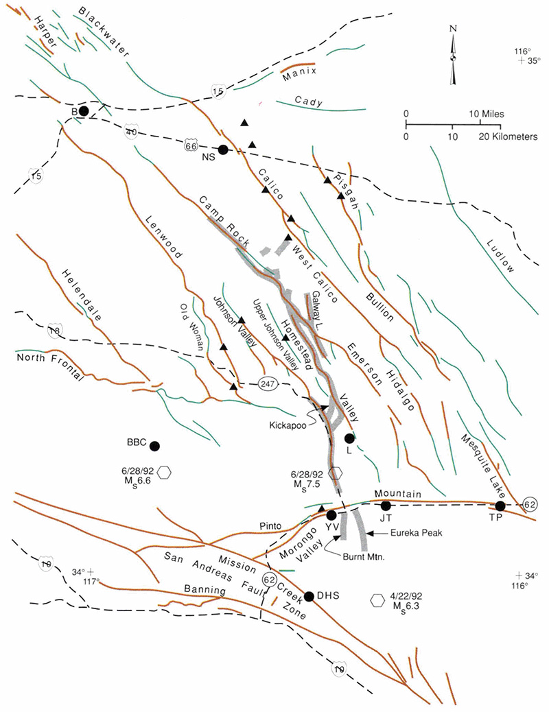 Figure B-1. Quaternary faults of the south-central Mojave Desert showing Holocene faults zoned under the Alquist-Priolo Special Studies Zones Act (rust lines) and other late Quaternary faults (green lines). Surface rupture zones associated with the Landers earthquake are identified by gray lines; triggered slip on other faults is shown by triangles. Hexagons mark epicenters. Letters identify cities: B = Barstow; BBC = Big Bear City; DHS = Desert Hot Springs; JT = Joshua Tree; L = Landers; NS = Newberry Springs; TP =Twentynine Palms; YV = Yucca Valley. Click/tap the image to open a larger version in a new window.
These ruptures came as a big surprise to the earth scientists who had studied these faults because: 1) faults previously considered to be separate structures were found to connect (Figure B-1); 2) the amount of surface displacement was two or three times as large as generally anticipated; 3) the magnitude of the earthquake was much larger than envisioned by seismologists for individual faults; and 4) seismicity was continuous across the active Pinto Mountain Fault.
Response
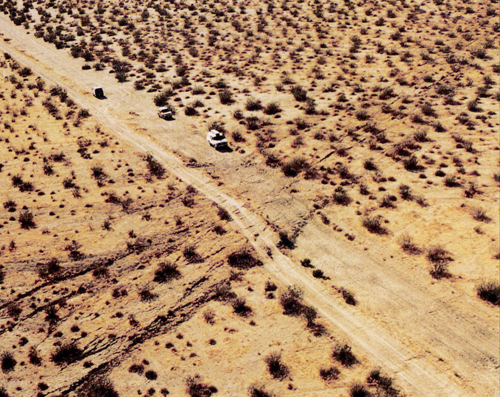
The Landers earthquake was felt by many in southern California, including author Jerome Treiman. He and other earth scientists checked for fault rupture as soon as the epicenter was located. Other geologists from the CGS, the U.S. Geological Survey (USGS), the California Institute of Technology (CIT), universities, consulting firms, and other organizations arrived during the next few days.
Initially, the extent, magnitude, and "sense of rupture" [sense of fault motion] were determined. Much of this information was channeled through the CGS earthquake clearinghouse. By July 1 or 2, most of the main ruptures had been identified and, to some extent, measured, but the desert terrain and its limited features did not permit most rupture traces to be plotted accurately on topographic base maps.
Aerial photographs (scale of 1:6,000, or 1 inch= 500 feet), taken by I.K. Curtis for USGS on June 30 and available July 3, greatly facilitated the mapping of fault ruptures. Although many of the faults could be seen on the air photos, it was necessary to examine them in the field to measure magnitude of slip and to provide continuity. Because of the large number of ruptures and because fractures degrade rapidly in soft alluvium, CGS joined the USGS and others to map the many strands of faults. The results presented in this article are preliminary and generalized. [Editor's note: More detailed and complete results were later published jointly with the USGS, while other preliminary reports on the Landers earthquake were prepared by Earthquake Engineering Research Institute (1992) and Geomatrix Consultants (1992)].
Tectonic Setting
The Landers earthquake occurred along part of a group of right-lateral, northwest-trending late Quaternary faults in the central Mojave Desert (Figure B-1). Near its southern end, the rupture zone is traversed by the east-west-trending Pinto Mountain Fault. The region is bounded on the southwest by the San Andreas Fault Zone and on the north by the Garlock Fault.
The principal faults and general structure of the Mojave Desert region have been summarized and discussed by Dibblee (1980). According to Dokka (1983), the principal northwest-trending faults of the south-central Mojave Desert have had 0.9 to 9.0 miles (1.5 to 14.5 km) of right-lateral displacement in late Cenozoic time. Recently active traces of these faults have been mapped by Bull (1978), Morton and others (1980), and Hart and others (1988) using tectonic geomorphology. Geodetic measurements between 1934 and 1982 suggest cumulative right-lateral slip (strain) of 0.26 ± 0.05 inch (6.6 ± 1.3 mm) per year along the northwest-trending faults of this region. Based on the development of tectonic geomorphic features and offset late Quaternary geologic units, the Pisgah-Bullion, Calico, and related faults to the west each appears to have a late Quaternary slip rate approaching 0.04 inch (1 mm) per year. Surface rupture in the central Mojave Desert prior to the Landers event was minor: it occurred on the Manix Fault in 1947, the Galway Lake Fault in 1975, and the Homestead Valley and Johnson Valley faults in 1979.
Description of Surface Ruptures
The epicenter was located south of Landers on the Johnson Valley Fault and ruptured mainly northward to the Homestead Valley, Emerson, and Camp Rock faults (Figure B-2). Rupture along the Johnson Valley Fault died out southward just north of Yucca Valley, but rupture appeared again to the south of the Pinto Mountain Fault. The zone of aftershocks is continuous and shows the Johnson Valley Fault to connect in the subsurface with the Burnt Mountain and Eureka Peak faults.
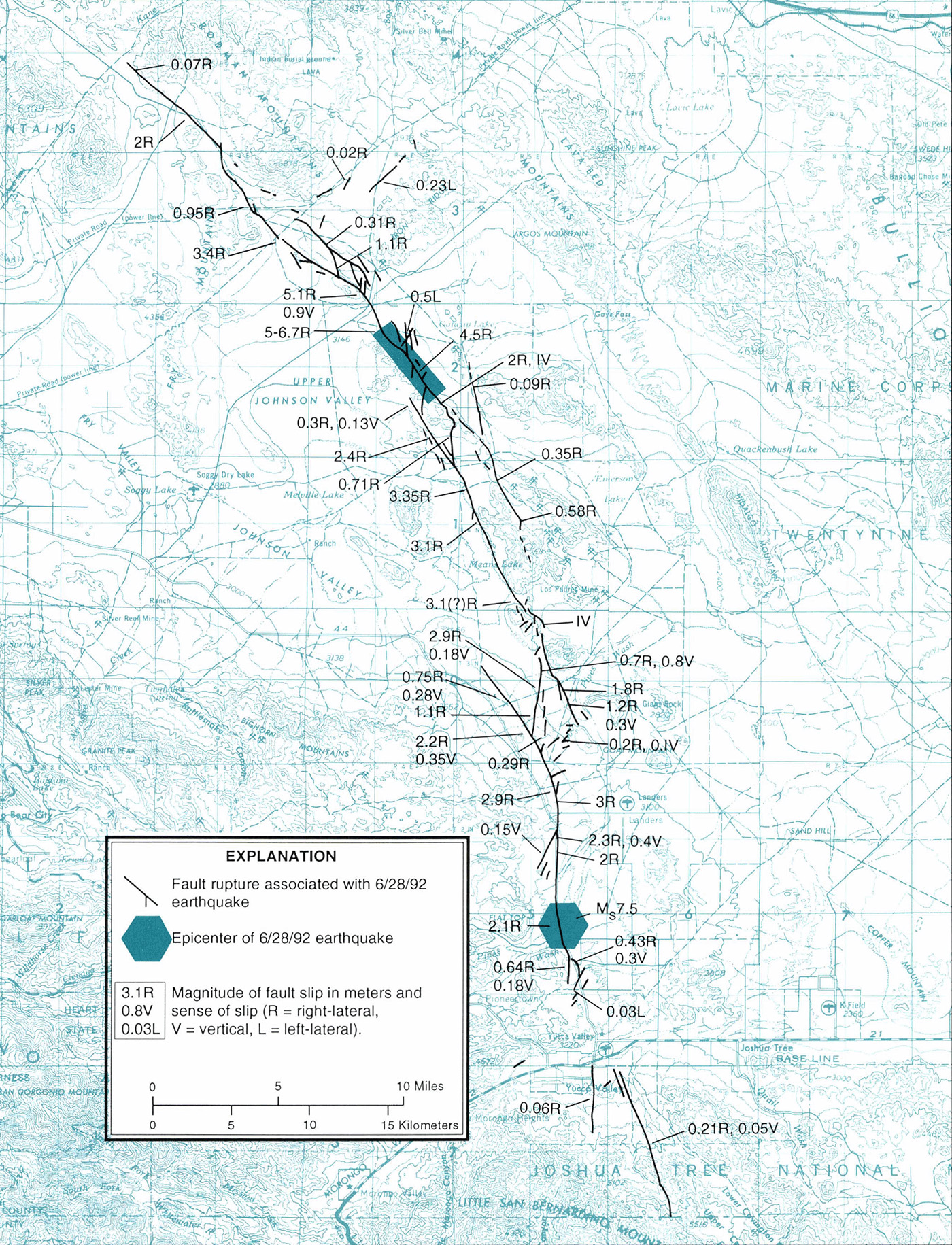 Figure B-2. Surface faulting associated with the 1992 Landers earthquake. Click/tap the image to open a larger version in a new window. For details of shaded area, see Surface Rupture Along a Portion of the Emerson Fault.
Most of the rupture was right-lateral strike-slip along north to northwest-trending faults, with maximum slip of 15 to 20 feet (4.6 to 6.1 m) on the Emerson Fault (Figure B-2). There was more than 3 feet (1 m) of right-lateral slip over 38 miles (61 km) of rupture. Left-lateral slip also occurred locally along northeast- to east-trending faults, but mostly was minor. Maximum left-lateral slip measured was about 1.5 feet (0.5 m), west of Galway Lake. A vertical component of rupture was also common and locally attained 3 feet (1 m) or more.
Zones of closely associated ruptures commonly were 33 to 66 feet (10 to 20m) wide. In some cases, there were two or three main breaks and, together with subsidiary faults, formed complex rupture zones at least 650 feet (200 m) wide. There were so many ruptures that many were obscured by reconstruction, traffic, and weather before they could be field mapped. Fortunately, most of the ruptures were recorded on aerial photographs shortly after the earthquake. The several segments of faults that ruptured (Figure B-2) are discussed below, from south to north.
Eureka Peak and Burnt Mountain Faults
These faults were not known prior to their rupture on June 28, 1992. There was no geomorphic evidence suggesting previous Holocene activity, but there was subtle evidence of the faults in older alluvium and bedrock. An exploratory trench across the northern part of the Eureka Peak Fault revealed caliche-filled fractures in alluvium. Both faults are right-lateral faults with minor down-to-the-west vertical components. Maximum right-slip on the Eureka Peak Fault was 8.3 inches (21 cm). There was nearly 1.6 inches (4 cm) of afterslip on this fault and about half of it occurred during the first 2 weeks after the earthquake. Little, if any, afterslip was recorded on other faults in the epicentral area.
Although these faults align with the Landers earthquake aftershock pattern, they do not extend continuously to the north or south as do the aftershocks. The faults also align with minor Quaternary faults to the south that are apparently related to the April 22, 1992 Joshua Tree earthquake of MS6.3. One of these faults showed minor right-lateral and down-to-the-west vertical slip.
Johnson Valley Fault
 Exposure of Johnson Valley Fault in hillside cut had 4.6 feet (1.4 m) of right-lateral and 1.0 foot (0.3 m) of vertical offset (scarplet at lower right). Vertical resistant feature is calcite-cemented fault breccia indicating previous faulting in Pleistocene alluvium. Note new fissures in breccia. Click/tap the image to open a larger version in a new window. Photo by E. W. Hart.
Rupture that caused the Landers earthquake was initiated at the southern end of the Johnson Valley Fault, at a depth of 5.6 miles (9 km). Only the southern half of the Johnson Valley Fault ruptured with the minor exception of triggered (?) slip near its northwestern end (Figure B-1). (Triggered slip occurs when strain stored along a fault at a shallow depth is released by shaking.) The fault was previously known and most of it was considered to be Holocene active. Maximum right-lateral displacement was about 10 feet (3 m) and most of the fault displayed more than 6 feet (2 m) of slip.
The surface ruptures splayed complexly at the south end and died out north of Yucca Valley. The fault segment connected complexly to the north with the Homestead Valley Fault, again along a continuous aftershock zone. Near its junction with the Kickapoo Fault, the Johnson Valley Fault previously had very minor, discontinuous surface rupture associated with the Homestead Valley earthquakes of 1979.
Kickapoo and Related Faults
 Newly discovered Kickapoo Fault near Charles Road shows relatively narrow zone of rupture along scarp up to 3 feet (1 m) high with nearly 3 feet (1 m) of right-lateral offset. Fault seemingly passes between house and outbuilding. Click/tap the image to open a larger version in a new window. Photo by W.A. Bryant.
These newly discovered faults constitute a major connection between the Johnson Valley and Homestead Valley faults. The main element is the Kickapoo Fault, which had a maximum of 9.5 feet (2.9 m) of right-lateral slip. The north end of the fault has a large vertical component forming an east-facing scarp about 3 feet (1 m) high. Only subtle and discontinuous evidence for this fault can be seen on air photos and in older (?) alluvium in the field. This stepover area is the approximate location of the 1979 M5.3 Homestead Valley earthquake.
Homestead Valley Fault
Virtually this entire 18-mile- (29 km) long fault ruptured in 1992, developing maximum right-lateral displacement of 11 feet (3.35 m). It has multiple strands forming a wide zone and connects complexly with the Emerson Fault. The southernmost segment, which had minor rupture in 1979, is separated from the central part of the fault by a complexly faulted hill. The eastern side of that hill (west-southwest of the Los Padres Mine) is bounded by a west-dipping thrust fault with a 3-foot- (1-m-) high scarp (Figure B-2). The Homestead Valley Fault ruptures diminish to the southeast and zones of discontinuous ruptures connect it with the Johnson Valley Fault.
Emerson and Galway Lake Faults
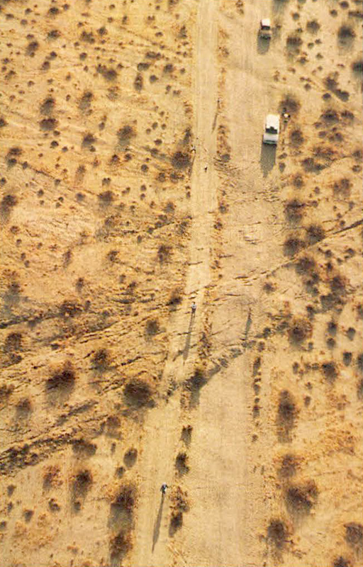
 Surface rupture along the Emerson Fault offsets road 15 to 20 feet (4.6 to 6.1 m) right-laterally, which is the near-maximum fault displacement measured for the Landers earthquake. Main rupture is a broad, fissured mole track or warp about 50 feet (15m) wide flanked by subsidiary fissures extending 50 to 100 feet (15 to 30m) on each side. Click/tap the image to open a larger version in a new window. Photo by W.A. Bryant.
Maximum rupture associated with the Landers earthquake occurred along the Emerson Fault near Bessemer Mine Road. There was 16.7 feet (5.1 m) of right-lateral slip just north of that road. Measurements of right-lateral displacement of a road just south of the Bessemer Mine Road range from 15 to 20 feet (4.6 to 6.1 m). Only the northwestern half of the Emerson Fault ruptured in this event, although the southeastern half is considered active (Figure B-1). To the northwest the fault connects complexly with the Camp Rock Fault, paralleling it for 8 miles (13 km). The Galway Lake Fault, at the southeast end of the Emerson ruptures, also ruptured with nearly 3.5 inches (9 cm) of right-lateral slip (this may have been triggered slip). The same segment had minor rupture in 1975. Except for some short segments, the Emerson Fault was previously recognized as a recently active fault.
Camp Rock Fault
Most of the central and southeastern parts of this fault ruptured with maximum right-lateral displacement of about 6 feet (2 m). The rupture, however, was discontinuous where the Camp Rock Fault parallels the Emerson Fault, and the northwestern part of the fault did not rupture (Figures B-1 and B-2). The magnitude of surface fault rupture diminished substantially to the northwest. Some ruptures splayed northeast (with as much as 9 inches [23 cm] of left-lateral slip) around the southeast side of the Rodman Mountains. This suggests that a new fault zone is developing between the Camp Rock-Emerson and the Calico-West Calico fault zones, which also had minor right-slip ruptures at three localities (Figure B-1). Ruptures on the Galway Lake Fault may be part of this complex stepover.
Triggered Slip on Other Faults
The Landers earthquake apparently triggered minor slip on several faults well beyond the primary fault-rupture zone. Although not well understood, this phenomenon is common with large earthquakes. Some triggered slip is coseismic and some occurs as creep or afterslip. Within the south-central Mojave Desert, rupture was triggered on the following faults (Figure B-1):
Pisgah Fault
0.8 to 1.6 inches (2 to 4 cm) right-lateral slip in two zones near the Hector Mine.
Calico-West Calico Fault
Maximum 0.8-inch (2-cm) right-lateral slip in three short northwest-trending segments. A broad 6-mile- (10-km-) long zone of north to northeast-trending cracks with as much as 4 inches (10 cm) of vertical offset developed east of the fault, 4 miles (6 km) northeast of Newberry Springs.
Johnson Valley Fault (northwest segment)
Minor zone of left-stepping cracks; 0.08 to 0.16 inch (2 to 4 mm) right-lateral slip.
Upper Johnson Valley Fault
Post earthquake photo interpretations suggest that fault rupture occurred along several miles of the newly named Upper Johnson Valley Fault. A field check in November verified cracks in at least three places in zones at least 32 feet (10m) wide.
Lenwood Fault
0.6- to 1.2-mile (1-2 km) long zone of left-stepping cracks south of Soggy Lake.
Old Woman Fault
Questionable minor extensional cracking; northwest trend.
Pinto Mountain Fault
Local minor cracking with up to 0.8 inch (2 cm) of extension; right-stepping cracks suggest left-lateral displacement.
Other triggered slip was reported in Imperial Valley on the Superstition Hills Fault, the East Branch of the Elmore Ranch Fault, and the Coyote Creek Fault and in Coachella Valley along the Indio Hills, Mecca Hills, and Durmid Hills segments of the San Andreas Fault. Maximum right-lateral slip on the San Andreas Fault was 0.83 inch (2 cm).
Effectiveness of Alquist-Priolo Special Studies Zones
On March 1, 1988, the CGS issued Official Maps of Special Studies Zones for faults in the central Mojave Desert. These maps were issued in accordance with the Alquist-Priolo Special Studies Zones Act of 1972 (Alquist-Priolo Act) to assist cities and counties in regulating development to mitigate surface faulting hazards to structures for human occupancy.[Editor's note, 2022: Special Studies Zones are now known as Earthquake Fault Zones (EFZs), and the Alquist-Priolo Special Studies Zones Act is now known as the Alquist-Priolo Earthquake Fault Zoning Act.] The 1988 maps were the result of a 1986-1987 study of the faults in the Mojave Desert, the eighth region to be evaluated under a 10-region plan. Under this plan, those faults with evidence of Holocene activity and reasonably well defined as surface features were zoned under the Alquist-Priolo Act. Mapping by CGS geologists was largely based on the interpretation of air photos with only limited field checking. The work of other geologists was also used. Faults zoned in the south-central Mojave Desert region are identified in Figure B-1.
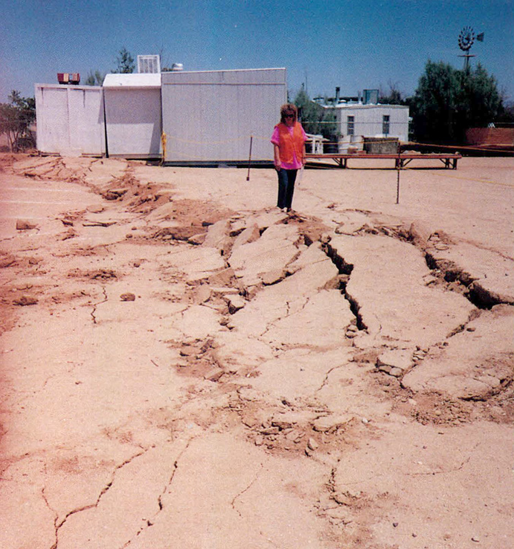
 House damaged by Kickapoo Fault. Although main scarp and rupture passes between house and outbuilding, numerous other fissures are distributed over a zone at least 50 feet (15m) wide. Much of the subsidiary rupture was diverted around the slab foundation of the house, offsetting the patio slab right-laterally more than 2 feet (less than 1 m). Click/tap the image to open a larger version in a new window. Photo by E. W. Hart.
The Landers earthquake provided an excellent opportunity to determine the effectiveness of the EFZs established in 1988. Based on preliminary data, approximately 55 percent of the fault rupture associated with the Landers earthquake occurred within the established EFZs. About 31 percent of the rupture was outside the EFZs along previously unrecognized faults, including branch and subsidiary faults and interconnecting faults. The remaining 14 percent of the rupture outside the EFZs occurred on previously mapped faults that did not appear to meet zoning criteria. An estimated one-third of the rupture outside the EFZs was relatively minor, with fewer than 4 inches (10 cm) of displacement. By way of contrast, only 38 percent of the fault rupture from the November 1987 Superstition Hills and Elmore Ranch earthquakes was within established EFZs. Again, part of that rupture occurred on previously unmapped faults and much of it was relatively minor.
Another method of measuring the effectiveness of zoning is to evaluate the percentage of zone length within which rupture occurred. For the Landers earthquake, between the south end of the Johnson Valley Fault and the north end of the Camp Rock Fault ruptures, 92 percent of the EFZs contained fault ruptures. The great majority of the rupture within the EFZs occurred within 200 feet (60 m) of the traces shown on the EFZ maps.
U.S. Bureau of Land Management photos (scale 1:30,000) were used for interpreting most of the region. Although the EFZs established for the Johnson Valley, Homestead Valley, Emerson. and Camp Rock faults appear to be effective (92 percent ruptured). additional active faults probably could have been identified on larger-scale air photos. Even with the best possible aerial photos, many of the faults that ruptured would not have been identified as active because they were largely obscured by alluvial processes and by mining, roads, and construction. It should be recognized that not all active faults can be identified in advance. Therefore, using these techniques. investigations for possible active faults or other types of potential ground failure prior to construction of critical and sensitive structures may be warranted.
On January 1, 1993, Preliminary Review Maps of new and revised EFZs were issued for the Yucca Valley and Landers areas where development was underway.
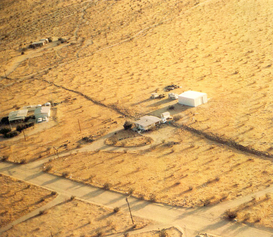
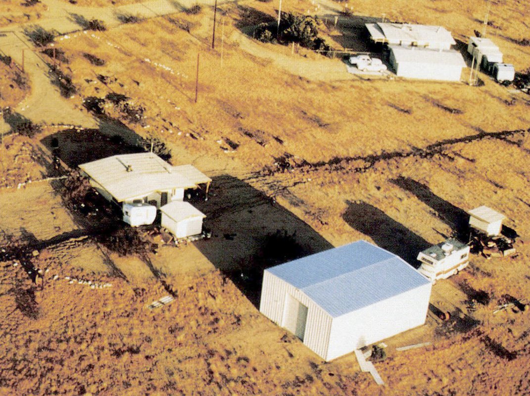
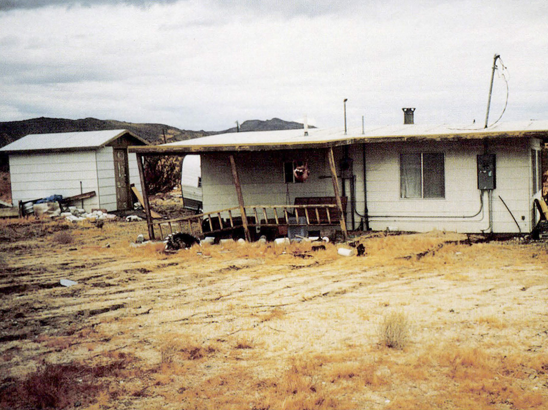
Although no comprehensive studies were made, it is apparent that many houses were damaged by the Landers fault ruptures—some extensively. A survey of air photos and limited field checking indicated 29 houses were damaged and an additional 50 houses may have been damaged by fault rupture in the Landers and Yucca Valley areas. There were no reports of structural collapse of houses or loss of life that resulted directly from fault rupture. However, an interior stone fireplace wall did collapse in one residence on a minor branch fault. It is clear that houses placed astride major active faults may sustain severe damage.
In places where ground deformation is distributive and displacements are not large, additional protection may be afforded by the use of reinforced foundations. It was noted that fault rupture, in some cases, was diverted around slab foundations and presumably reduced "internal" damage to the structures.
Rockfalls and Surface Effects other than Faulting
By ALLAN G. BARROWS, Geologist; with contributions from Pam Irvine, Steve Bezore, Tim McCrink, Mark DeLisle, Dave Keefer, Randy Jibson, Jeff Knott, Richard Willette, and Wes Reeder.
Contents
 1. Vehicle-size block shaken loose during Big Bear earthquake 5 miles (8 km) east of Barton Flats Campground on Highway 38. Although very close to epicenter, this was the only debris on road. Note hole in pavement to left of block. Click/tap the image to open a larger version in a new window. Photo by Jeff Knott, Caltrans, taken at 11:00 a.m., June 28, 1992.
Introduction
For much of the day following the early morning M7.5 Landers and M6.6 Big Bear earthquakes, dense, white clouds of dust, resulting from nearly continuous rockfalls, concealed the deep canyons and rugged mountain peaks in the eastern San Bernardino Mountains. Elsewhere in these mountains, widespread rockfalls from roadcuts and steep slopes made some roads impassable or dangerous for several days following the earthquakes. Geologists found evidence of rockfall and streambank sloughing in relatively few localities in the 2,700-square-mile (7,000 km2) area (see map below).
Oddly enough, in spite of forceful and prolonged shaking, the Landers and Big Bear earthquakes neither triggered massive landslides nor remobilized existing slumps or block glides in the San Bernardino Mountains. Consequently, the effects of the June 28, 1992 earthquakes contrast dramatically with the extensive landsliding triggered by the M6.4 San Fernando earthquake of February 9, 1971 or the M7.1 Loma Prieta earthquake of October 17, 1989.
 Limits of area affected by surface faulting, rockfalls, and other surface geologic effects of the Landers and Big Bear earthquakes, June 28, 1992. Numbers in squares are localities of photos in this article. Click/tap the image to open a larger version in a new window.
M7.5 Landers Earthquake
Regional Setting
The region subjected to the strongest shaking associated with the Landers earthquake is typical Mojave Desert terrain. It is characterized by rugged, nearly barren, fault-bounded mountain ranges that border broad valleys comprised of coalescing alluvial fans and, locally, scattered playas. Exposed in the mountains and dispersed hills are older, granitic and metamorphic "basement" rocks and younger volcanic rocks. Sedimentary rocks are nearly absent in this region. The drainage system consists of sandy, gravelly washes incised by steep to vertical-walled channels.
Rockfalls
 2. Large boulder (shaken loose during Landers earthquake) that rolled down this windblown, sand-covered slope on the east side of mountains north of Homestead Valley. Boulder came to rest within 3 feet (1 m) of the Homestead Valley Fault, which crosses sand immediately behind boulder. Click/tap the image to open a larger version in a new window. Photo by G. Barrows.
Rockfalls were triggered near surface fault rupture, particularly 21 miles (35 km) north of Yucca Valley (15 miles or 25 km north of the epicenter) in the mountains between the Homestead Valley and Emerson faults. Large blocks that had weathered out of the typical jointed bedrock on the slopes rolled, slid, and even bounced to the base of the slopes.
Bank Collapse
North of Yucca Valley where Old Woman Springs Road crosses Pipes Wash, 1 to 2 miles (2 to 3 km) south of the epicenter, roadcut failures occurred only where there was surface faulting (along the Johnson Valley Fault) within a few hundred yards (meters) of the highway. The north-facing bank of Pipes Wash, west of the highway, exhibited very shallow landslides within 1, 600 feet (500 m) of the road.
Triggered slip on the Calico Fault, 34 miles (55 km) north of the epicenter, was marked by localized sloughing of the vertical bank of Box Canyon Wash in the Rodman Mountains. It is noteworthy that bank sloughing was seen only within 600 feet (200 m) of the area of minor surface rupture.
Fissures, Extensional Cracks, and Settlement Features
Prominent earthquake shaking effects were widespread in the area between the Camp Rock and Calico faults, 28 to 31 miles (45 to 50 km) north of the epicenter. Many northeast-trending fissures developed across the alluviated area between the Rodman Mountains and Iron Ridge. There is a series of short, right-stepping cracks, striking N50° to 60°E where the road paralleling the steel-tower power-transmission line crosses a rocky projection of the Rodman Mountains, 1.25 mile (2 km) east of the Camp Rock Fault. Lateral displacement was not seen on these cracks, which typically were open only about 1/ 2 to 1 inch (1 or 2 cm). The cracks coincided with caliche-filled zones in the rocks, indicating that cracks developed earlier in the same place. This suggests they are not random shaking features but reflect an underlying tectonic pattern, perhaps as part of a conjugate set with the bounding Camp Rock and Calico faults.
A couple miles east of the above-described cracks, in the Silver Bell Mine quadrangle, a zone of right-stepping fissures could be followed across the desert for more than 2 miles (3 km). The zone ranges from a single crack to a 200-foot( 60-m-) wide belt containing dozens of fissures. Most of the cracks appeared to be purely extensional features with collapsed walls that, locally, were open to depths exceeding 3 feet (1 m). At several places, however, left-lateral displacements of up to 9 inches (23 cm) were measured. This particular zone of fissures strikes toward a knoll known as Ford's Knob, upon which sits a microwave relay tower. The road to the tower along the west side of the hill was blocked by abundant rockfalls and seriously damaged for about 1,600 feet (500 m) by settlement of the downslope (west-facing) part of the roadway embankment.
The exceptional features in this vicinity, nearly 31 miles (50 km) from the epicenter, testify to the strength of the earthquake shaking. The simplest explanation for such pronounced manifestations of strong shaking relates to a peculiarity of the Landers earthquake event. According to seismologists, during the Landers earthquake "energy was released in two sub-events, with the first sub-event starting at the epicenter and the second sub-event at approximately 40 kilometers [25 miles] to the north-northwest and starting about 10 seconds after the beginning of the rupture." The second sub-event, which released more energy than the first, began along the Emerson Fault only about 6 miles (10 km) from the features described above.
Earthquake shaking was unusually forceful at the small desert community of Newberry Springs, 17 miles (27 km) east of Barstow. The California Strong Motion Instrumentation Program station at Yermo, 52 miles (84 km) from the Landers earthquake epicenter recorded a peak acceleration of 0.25 g. The strength of the earthquake in this vicinity can be attributed to the second sub-event that started on the Emerson Fault, about 22 miles (35 km) south of Newberry Springs, and the northward propagation of the faulting.
In Newberry Springs, north of Interstate Highway 40, several northeast-trending fissures ruptured streets on the east side of Mojave Valley. Three prominent extensional cracks, striking N30° to 35°E, crossed Valley Center Road. The crack 0.8 mile (1.3 km) east of Newberry Road had a west-facing scarp with 2 inches (5 cm) of relief. Cracks 1.1 miles (1.8 km) and 1.25 miles (2.0 km) east of Newberry Road had 2.3-inch (6-cm) scarps facing each other where they crossed Valley Center Road. These cracks, which could be traced mostly as open, extensional fissures for more than 980 feet (300 m), bounded a down-dropped block or swale-like depression along Valley Center Road. The relief on this down-dropped block between the two cracks is 5 to 6 feet (1.5 to 2m). Accordingly, the earthquake cracks formed where a pre-existing trough-like channel occurs in the lakebed deposits of Mojave Valley. A 1.2-inch- (3-cm-) high, east-facing crack developed across Silver Valley Road, 0.56 mile (0.9 km) east of Newberry Road, that also mimicked the existing gentle topography. An explanation for the development of the series of fissures in Mojave Valley may lie in the rapid decrease in the water table, due to pumping, in this area. Prominent fissures have developed, mostly aseismically, in many places in the arid southwest where there has been rapid withdrawal of ground water.
Additional Shaking Features
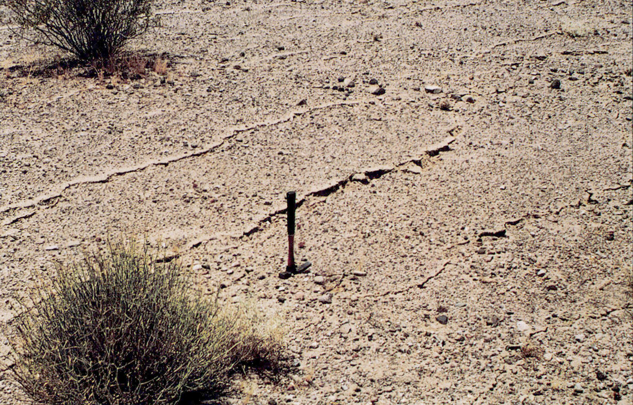 3. Small, N15°W-trending extensional cracks within a broad zone of such features along the Pisgah Fault north of the Hector Mine. Prolonged shaking cleared the surface of pebbles on the west side (pebbles fell into crack) resulting in light-colored bands along each crack. Click/tap the image to open a larger version in a new window. Photo by A. G. Barrows.
A concentration of surface effects was also seen along a 3-mile (5-km) stretch of the Pisgah Fault near the Hector Mine, some 38 miles (60 km) from the epicenter. One soil-fall occurred in a prospect pit. However, cracked or shattered crusts aligned with the fault trace were more common. The shattered crusts were on piles of prospect pit debris rich in dry, brittle clay. In addition, a broad zone of cracks developed over an area of about half a square mile (1 or 2 km2), east of the trace of the Pisgah Fault north of the Hector Mine. Due to prolonged, eastward- directed shaking, pebbles fell from the western surface into many of the northwest-trending cracks.
Big Bear Earthquake
Regional Setting
The region where the strongest shaking was concentrated during the Big Bear earthquake lies in the eastern and central San Bernardino Mountains. Here, maximum variation in elevation exceeds 2,000 feet (610 m) over a horizontal distance of 1 mile (1.6 km). The rocks are predominantly igneous and metamorphic with minor sandstone and conglomerate units.
A combination of several factors contributed to the severity of the slope-failure features triggered by the Big Bear event including steep slopes, shattered rocks in a complex tectonic environment of multiple major fault strands, frost-wedging at higher elevations, and lack of a continuous ground cover to protect the surface. In such places rockfalls are common, even without powerful earthquake shaking.
In the vicinity of the Big Bear earthquake epicenter many very large ancient landslide masses had been mapped. In fact, the epicenter was on a very large landslide on the slopes of Sugarloaf Mountain 5 miles (8 km) southeast of Big Bear Lake. Elsewhere in the San Bernardino Mountains, a number of recently active or troublesome landslides had been mapped. Directly after the earthquake, several geologists checked the known large landslide masses and the young problematic ones and did not find clear evidence of remobilization.
Rockfalls
Nearly continuous rockfall activity in the deeply dissected wilderness terrain south of 11,499-foot (3,500-m) San Gorgonio Mountain was triggered by the Landers and Big Bear earthquakes and their abundant aftershocks. The eastern San Bernardino Mountains were obscured by the dense gray clouds of dust rising like smoke all day on June 28. The very steep to vertical, nearly barren walls of the 1,800-foot- (550-m-) deep amphitheater at the head of Mill Creek and the 2,000- foot- (610-m-) deep amphitheater at the head of the Middle Fork of Whitewater River were the sources of much of the broken rock and dust that tumbled, rolled, and fell down chute-like ravines during and for several days after the earthquakes.
Fresh rockfalls were observed on the slopes of the Little San Bernardino Mountains eastward into the Joshua Tree National Monument and on both sides of Morongo Valley as well as in the deeply dissected canyons of the San Gorgonio Wilderness. State Highway 38, which is the only paved road across the epicentral area of the Big Bear earthquake, was closed between June 28 and July 3 to allow for road cleanup and repair. Very near the epicenter of the Big Bear earthquake, 5 miles (8 km) east of Barton Flats, a single large rock tumbled onto Highway 38.
An unusual phenomenon in Mill Creek Canyon was described by Tom Wellman, Fire Chief of Forest Falls. There were three "fraction" [friction] fires near Mountain Home Village, ignited by sparks generated by falling rocks striking others.
Blockfalls
 5. The room-sized block (20 x 12 x 12 feet / 6.1 x 3.7 x 3.7-m) in the background came to rest approximately 100 feet (30 m) from the structure on the right. Click/tap the image to open a larger version in a new window. Photo by Siang Tan.
 4. Looking southwest across Mill Creek Canyon near the community of Forest Falls. The irregular, light colored streaks are debris flow scars and creek ravines. The thin line left of center is the track through the trees cut by the large block pictured in the previous photo. Click/tap the image to open a larger version in a new window. Photo by A. G. Barrows.
About two dozen granodiorite blocks, each weighing between 50 and 300 tons (45 and 270 metric tons) and measuring as much as 18 feet (6 m) long, were shaken from jointed, ledge-like outcrops close to the trace of a branch of the Mill Creek Fault. They tumbled 600 to 800 feet (180 to 250m) down the south wall of Mill Creek Canyon, breaking mature trees and landing 30 to 100 feet (10 to 30m) from various structures. The blockfalls occurred in an area 9.3 miles (15 km) southwest of the epicenter, on a line that coincides with the N45°E orientation of the fault that generated the Big Bear earthquake. Although there were no injuries or structural damage from the blockfalls of June 28, many of the southernmost structures in the community of Forest Falls are in a rockfall hazard zone.
Additional Shaking Features
For the Big Bear earthquake, the greatest ground acceleration recorded by a California Strong Motion Instrumentation Program ground-response station was 0.57 g at the Civic Center in Big Bear Lake, 7 miles (11 km) from the epicenter. Damage was restricted to communities in the San Bernardino Mountains. Liquefaction-induced lateral spreading fissures damaged structures in the Pan Hot Springs area, east of the intersection of Highway 18 and Paradise Way in Big Bear. At the hot springs facility there were arcuate cracks striking N20°E, with 0.5- to 2-inch (1- to 5-cm), down-to-the-east, vertical displacements. Numerous cracks also developed in the meadow to the southeast. McCrink and DeLisle concluded that shallow ground water from the artesian spring and the location of the facility on a sandy alluvial fan made the site susceptible to liquefaction.
 6. Down-to-the-north, curving fissure, related to lateral spreading. It is traceable for 820 feet (250 m) across unpaved River Road 0.8 mile (1.3 km) west of its junction with Highway 38 near South Fork Campground (along the south side of the canyon of the Santa Ana River, close to the epicenter of the Big Bear earthquake). Click/tap the image to open a larger version in a new window. Photo by Siang Tan.
On the south bank of the Santa Ana River, about 0.8 mile (1.3 km) along River Road, west of its junction with Highway 38 near South Fork Campground, an 800-foot (250-m) zone of curved cracks developed in a wooded area at the base of the slope and disrupted unpaved River Road. The cracks were as much as 4 inches (10 cm) wide and, locally, exhibited down-to-the-north displacements of as much as 12 inches (30 cm). Apparently, they formed in response to strong shaking and were locally accompanied by sand boils. Surface fault rupture was not found in this area.
McCrink and DeLisle (CGS) observed a set of linear cracks trending N70°E that cut across a stream terrace deposit on Patterson Road along the north side of the Santa Ana River about 0.5 mile (800 m) southwest of the Converse Flats Fire Station. The cracks probably resulted from minor lateral spreading of the terrace material, toward the Santa Ana River.
Surface Rupture Along a Portion of the Emerson Fault
By Pamela J. Irvine and Robert L. Hill, Geologists; with contributions from Dinah O. Shumway and Dr. Allan G. Barrows.
Contents
Introduction
Some of the most spectacular surface fault-rupture features, including the greatest surface displacement associated with the Landers earthquake, are in the study area along the northern portion of the Emerson Fault, approximately 25 miles (40 km) north-northwest of the earthquake’s epicenter. That the greatest surface displacement occurred so far from the epicenter is unusual but consistent with a preliminary analysis of earthquake source parameters by seismologists. The analysis indicates that seismic energy from the earthquake was released as two sub-events: the first originating at the epicenter near Landers, and the second, stronger sub-event 25 miles (40 km) north of the epicenter, in the vicinity of the northern Emerson Fault.
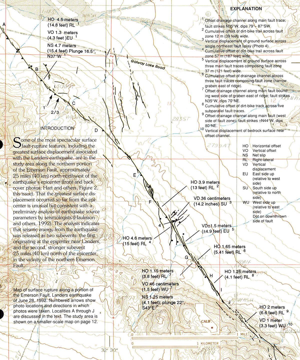 Map of surface rupture along a portion of the Emerson Fault, Landers earthquake of June 28, 1992. Numbered arrows show photo locations and directions in which photos were taken. Localities A through J are discussed in the text. Click/tap the image to open a larger version in a new window. The study area is shown on a smaller-scale map (Figure B-2 in Surface Faulting Associated with the Landers Earthquake).
Surface rupture along this part of the Emerson Fault was mapped on July 8, 9, and 11, 1992, by geologists with the CGS as part of a cooperative field investigation initiated by CGS and the U.S. Geological Survey (USGS) shortly after the Landers earthquake. The purpose of the field investigation was to document the location and nature of the surface rupture and to measure the displacement along the fault zone.
The part of the Emerson Fault involved in this study is a 3.4-mile (5.5-km) segment extending from Galway Lake Road (SE corner of Sec. 4, T. 5 N., R. 4 E.) southeast to a small playa in the NE corner of Sec. 23, T. 5 N., R. 4 E. of the Iron Ridge USGS 7.5-minute quadrangle (see map). Fault-rupture features were mapped on vertical aerial photographs at a scale of approximately 1:6,000 (1 inch = 500 feet) and data were transferred onto the USGS 7.5-minute quadrangle map at a scale of 1:24,000 (1 inch = 2,000 feet).
Geologic Setting
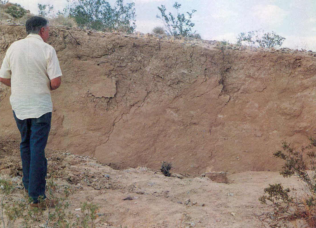
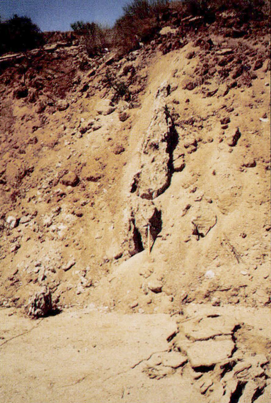
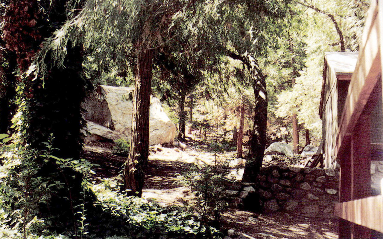
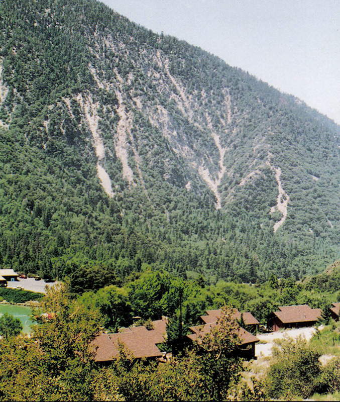
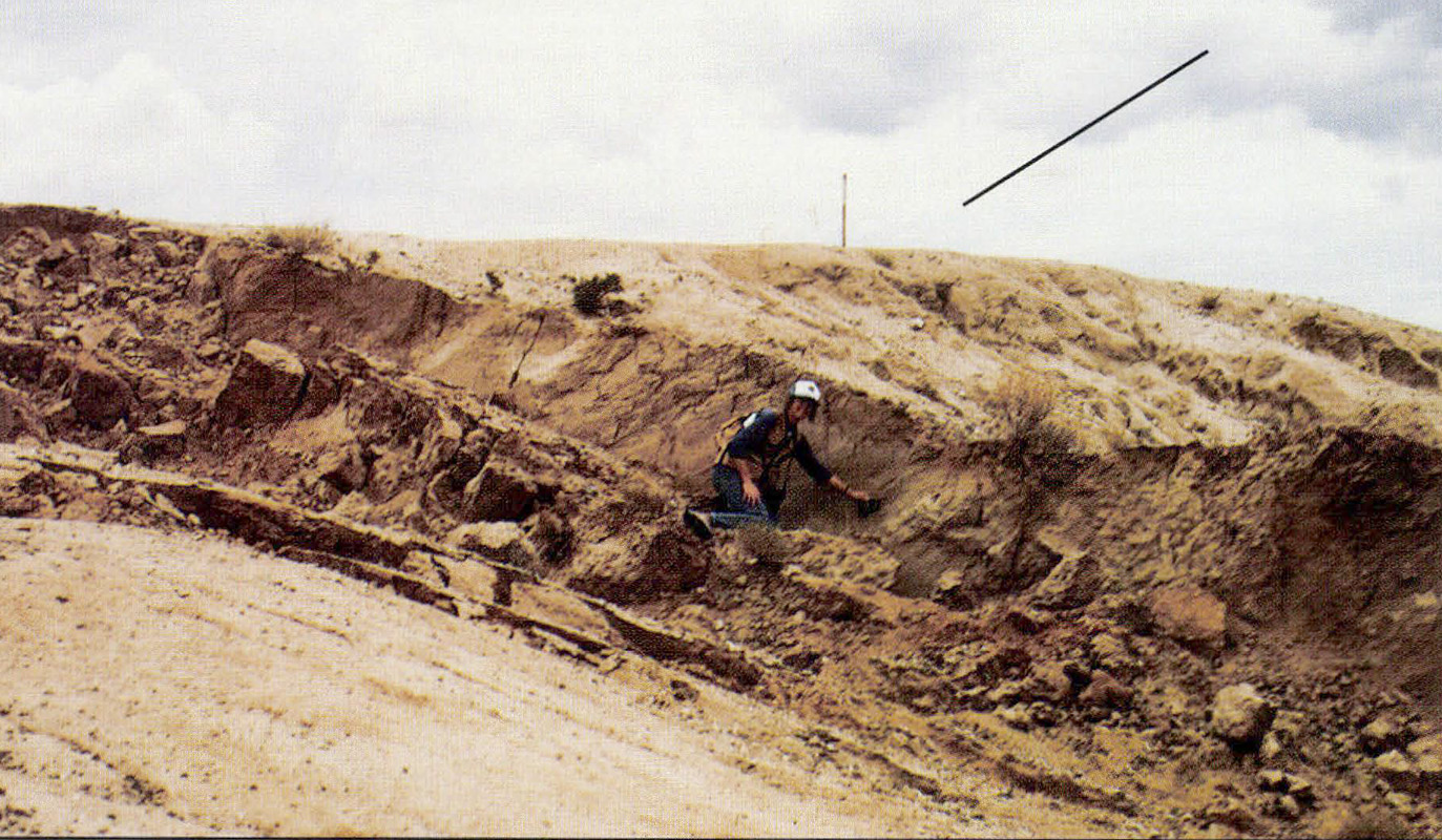
The regional geology is summarized by Dibblee (1964) and Bortugno and Spittler (1987). The study area is in the western Mojave Desert geomorphic province, an area characterized by northwest-trending mountains and valleys bounded by Quaternary (less-than-2-million-year-old) faults. The oldest rocks exposed in the study area are hornblende diorite and quartz monzonite of Jurassic and Jurassic-Cretaceous(?) age (between 66 and 208 million years old). These granitic rocks form the rugged mountains and hills on the east side of Upper Johnson Valley (cover photo).
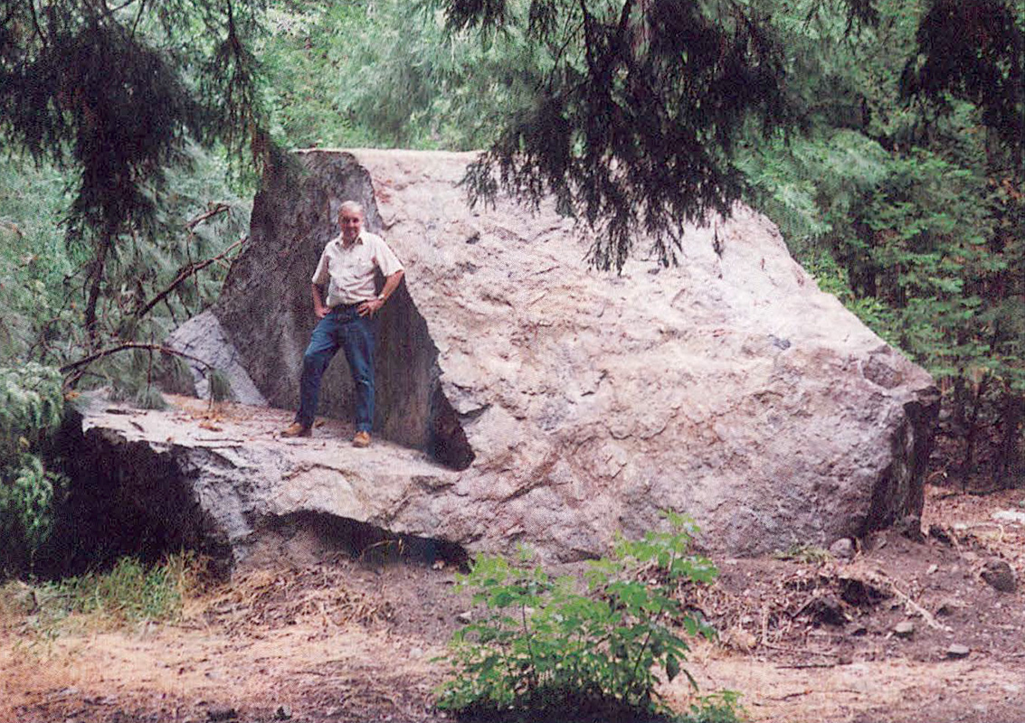
Younger rocks in the study area include nonmarine sandstone and siltstone of possible Pliocene age (between 1.6 and 5.3 million years old), which are mantled by younger gravels and form low hills with badlands topography east of the bedrock ridge (back cover photo, center). Also included are Quaternary-age older alluvium composed of semi-consolidated sandstone and conglomerate, which forms gently sloping dissected surfaces (cover photo, center).
The most recent deposits are the clay and fine silt deposited in the playa at the south end of the study area (cover photo, center), and the younger alluvium (unconsolidated sand and gravel), which forms broad fans sloping gently toward the east.
The northern portion of the Emerson Fault lies along the northeast flank of the mountains which form the eastern boundary of Upper Johnson Valley. Evidence of previous surface faulting is preserved in the geomorphology of the area as abrupt linear boundaries and depressions along bedrock ridges, and older, subdued fault scarps bounding uplifted Pliocene (?) sedimentary rocks and older alluvial fan deposits.
Surface Rupture
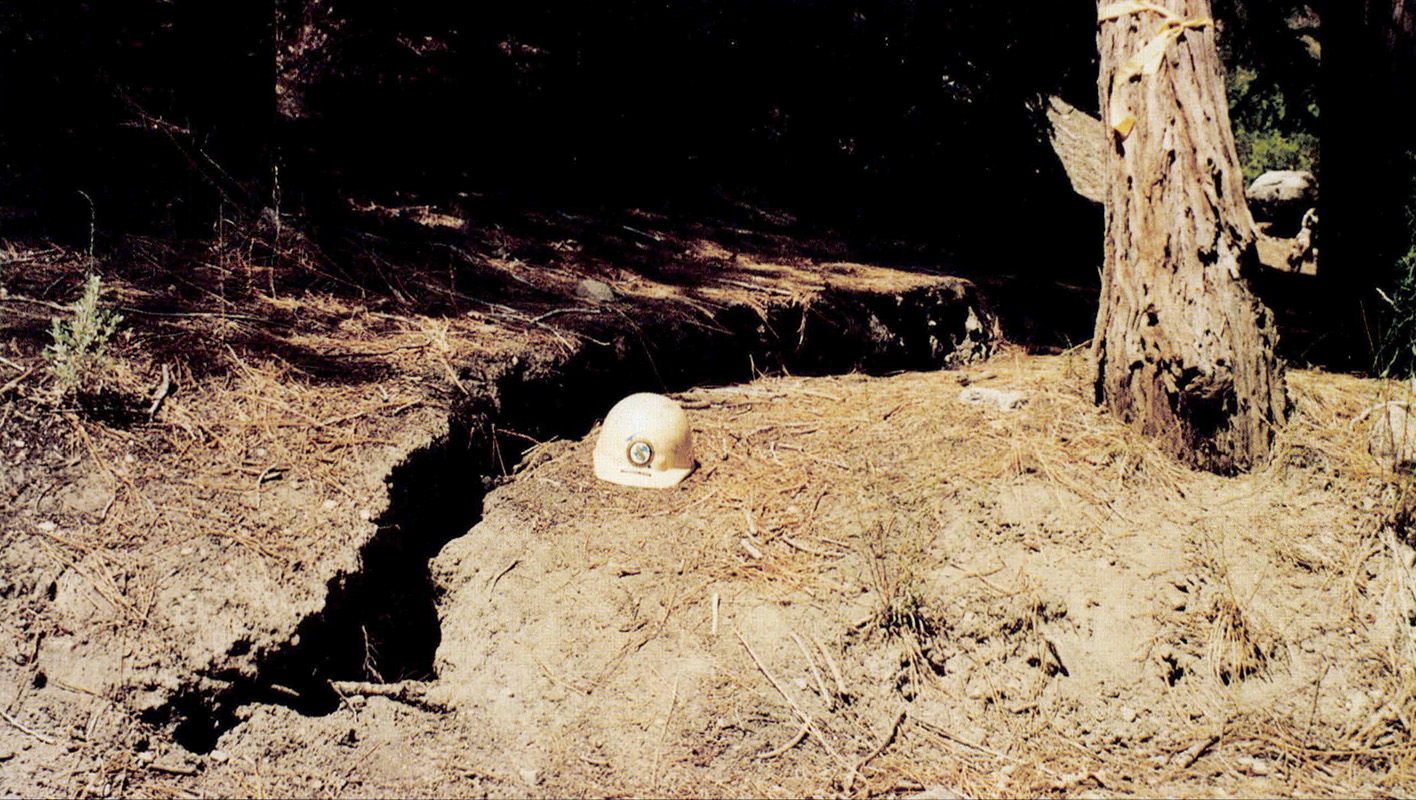
Surface rupture associated with the Landers earthquake has affected all the rock types in the study area, including the playa sediments and recent alluvium deposited in active drainage channels. Much of the current fault rupture appears to follow older fault-rupture features, such as older fault scarps, but some occurs several yards (meters) to tens of yards away from the older features. One possible reason the main rupture zone does not always occur at the base of the older scarps is that most of the older fault scarps have been modified by erosion. It is also possible that some current rupture has occurred along new fault segments or along older fault segments that have not been active for a long time. In addition to the main northwest-trending fault rupture zone, there are several significant rupture splays that trend north or northeast from the main zone.
Observations of offset features along the main rupture zone demonstrate that relative movement along the zone was right-lateral-oblique with a predominant horizontal (right-lateral) component and a subordinate vertical (east-side-up) component. In other words, the block on the east side of the fault moved to the southeast and up relative to the block on the west. Where the trace of the main rupture zone changes orientation, the surface rupture becomes more complex, and some segments within the zone display right-lateral oblique offset with the west side up. The character of surface rupture also changes where the rupture zone passes through different rock and sediment types. The zone is more discrete within older, more consolidated rocks and becomes diffuse and less distinct within younger, unconsolidated sediments (back cover photo).
 View toward northeast at offset south slope of ridge. Geologist is holding Brunton compass to striations (small, parallel grooves and ridges not visible in this photo) on fault surface. Striations indicate direction of slip (actual rather than "apparent" movement) along a fault. Line in upper right quadrant of photo is oriented parallel to the striations. (Photo 2 is a close-up of striations at another locality.) Larger-scale undulations called mullions are commonly observed on fault surfaces, indicating direction of slip. Mullions are visible in this photo and are oriented with their long axes parallel to the striations. Click/tap the image to open a larger version in a new window. Photo by R.L. Hill.
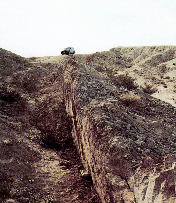
Significant surface faulting and fracturing also occur in a zone that extends more than 1.2 miles (2 km) east of the main rupture zone. Some of these features are shown on the map but they, along with the more subtle fractures observed along the main rupture trace, are too numerous to discuss in this article. Therefore, the following descriptions will be limited to major fault-rupture features observed along the main rupture zone of the Emerson Fault from Galway Lake Road south to the small playa (front and back cover photos). Localities A through J are shown on the map.
Maximum right-lateral displacement resulting from the Landers earthquake occurs where the main trace of the Emerson Fault crosses Galway Lake Road (Locality A). The fault rupture zone at this location consists of three or more fault traces producing a cumulative right-lateral offset (of the road) of approximately 20 feet (6 m).
Surface rupture along the fault between Galway Lake Road and the ridge 0.5 mile (800 m) to the south (between localities A and B; and back cover photo, bottom half is characterized by left-stepping en echelon fault scarps trending N32°-37°W, which form elongate compressional ridges (mole tracks) in the younger alluvium. The main rupture zone is approximately 50 feet (15m) wide with minor cracks extending more than 82 feet (25m) beyond the main zone. Fault rupture does not consistently follow older fault scarps but, in some areas, does occur at the base of previously uplifted older alluvium.
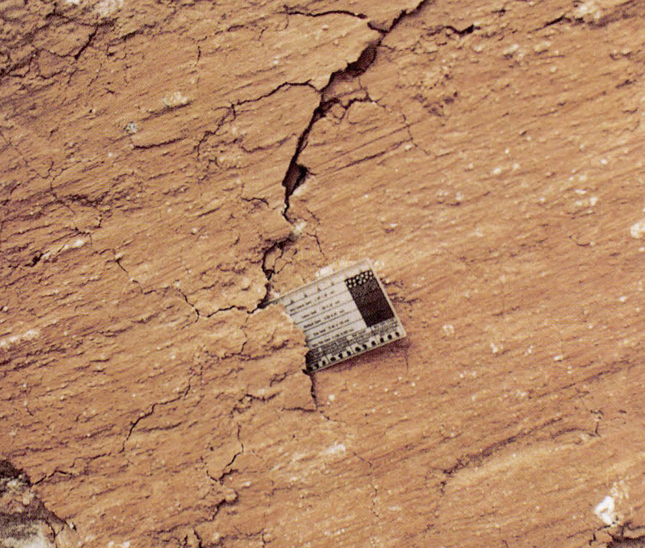 Close-up of slickenside striae (small, parallel grooves and ridges) on fault surface in Photo 3. View is to northeast, perpendicular to the fault. Striations indicate the block east of fault has moved diagonally upward and to the southeast (to the viewer's right). Striations plunge 23° from the horizontal. They are on gouge (or fault gouge) which consists of finely crushed and pulverized rock and mineral fragments and clay. The thickness of the gouge at this location and elsewhere along the fault indicates that movement has occurred intermittently, probably many times over a period of perhaps several hundred thousand years or more. Click/tap the image to open a larger version in a new window. Photo by R.L. Hill.
 View looking northeast along fault scarp. Click/tap the image to open a larger version in a new window. Photo by B.M. "Uncle Ben" Irvine.
The most dramatic fault-rupture features occur on the ridge 0.5 mile (800 m) south of Galway Lake Road (between localities B and C) where the fault passes through the older, more consolidated Pliocene (?) sandstone and siltstone forming the ridge. Fault rupture in the northern part of the ridge is characterized by a distinct fault scarp trending N35°W and dipping 79°-89°SW with the east side up, and several smaller, subparallel fault scarps splaying to the east and west from the main trace. Right-lateral-oblique movement along this segment of the fault has offset stream channels about 15 feet (4.5 m) and created fault scarps 4.3 feet (1.3 m) high. Numerous shaking cracks and some seismically-induced gravity slides occur near the top of the ridge east of the main rupture zone.
The northern portion of the ridge appears to have been displaced northward as a seismically-induced, large, incipient landslide bounded by an arcuate zone of surface rupture. On the east flank of the ridge, the rupture zone consists of north-trending cracks and fissures that displace the ground surface as much as 13 inches (33 cm), north side down. In the alluvium near the base of the ridge, these features become discrete cracks or narrow zones of cracks with a more northwesterly trend. These discrete cracks offset drainage channels as much as 7.9 inches (20 cm) right-laterally, and displace the ground surface as much as 3 inches (7.6 cm) vertically, west side up. The cracks and fissures on the ridge are extensional features interpreted to be the break-away zone at the head of the landslide. The discrete cracks in the alluvium are compressional features interpreted to be the lateral margin and toe of the slide.
In the central and southern part of the ridge, the main trace of fault rupture changes orientation, trending N68°W and dipping 83°NE, as it crosses over the ridge toward the southeast. This fault scarp provides excellent exposures of fault gouge and striations (Photos 1, 2, and 3). The main fault scarp splays into numerous small scarps at the south end of the ridge. These smaller scarps display the same right-lateral, east-side-up displacement as the main discrete fault scarp. Several arcuate zones of shaking cracks occur on top of the ridge west of the main rupture zone.
South of the ridge, the fault crosses gently sloping hills made of Pliocene (?) sandstone and siltstone and older alluvium (between localities C and D). The rupture zone consists of three or more left-stepping, east-side-up, en echelon faults.
The main fault-rupture trace becomes less distinct farther to the south as it crosses younger alluvium in the active drainages (between localities D and E). The fault-rupture zone in this area consists of a main scarp, east side up, with many small-scale, en echelon fractures. Older alluvium east of the recent fault rupture forms older, west-facing scarps.
Between localities E and F, the main rupture trace steps to the right, forming a graben (fault-bounded, down-dropped block) in the younger alluvium.
The main trace of surface rupture becomes very complex south of the graben (between localities F and G) and is characterized by several left-stepping en echelon as well as anastomosing fault scarps and numerous compressional and extensional features along its length. The trend of the rupture zone in this area is about N35°W. Several prominent zones of surface rupture splay to the northeast and southwest from the main zone (cover photo, lower center).
This complex rupture zone continues to the south, trending N35°-N40°W, along the east side of a ridge made of older alluvium (between localities G and H). A narrow graben has formed near the east base of this ridge, and stream channels have been offset in a right-lateral-oblique sense along three faults, resulting in 5.41 feet (1.65 m) of cumulative right-lateral offset (cover photo). The rupture zone becomes more diffuse as it continues south between the ridge and the playa.
The playa (between localities H and I; and cover photo) displays many interesting surface-rupture features. The main rupture zone crosses the playa's eastern margin, about 75 feet (23 m) west of the older fault scarp and consists of several subparallel traces in a zone approximately 50 feet (15m) wide. Relative movement determined from measurements of offset dirt-bike tracks is right-lateral-oblique, east side up. There is a zone of fractures displaying compressional and extensional features west of the main rupture zone (cover photo).
The rupture zone continues south as a diffuse zone of cracks and left-stepping en echelon fractures that splay toward the south-southwest into younger alluvium (between localities I and J). There are numerous rockfalls near the southern end of the study area where the main trace of surface rupture extends onto the flank of the bedrock ridge (locality J and cover photo).
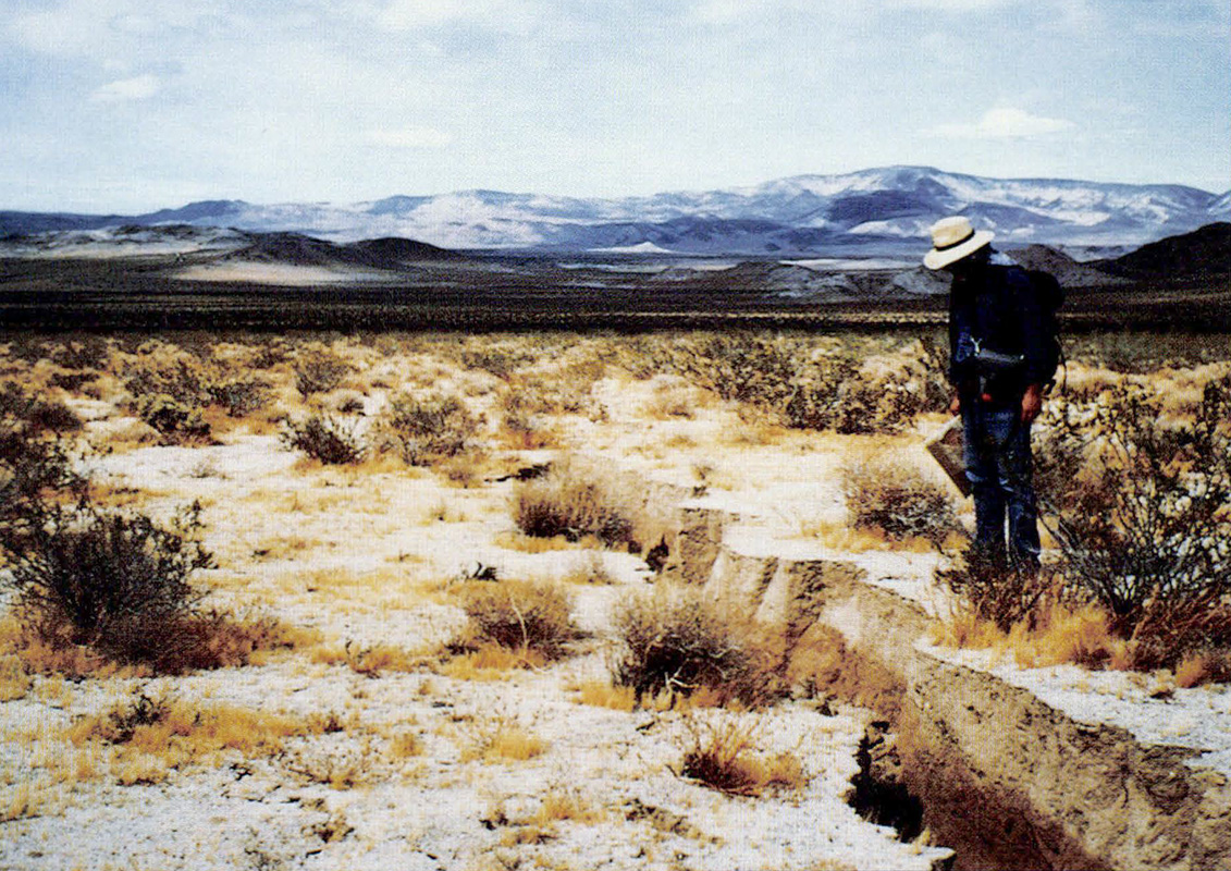 Northeast-trending fault splay. The ground surface on which the geologist is standing, southeast of the splay, has been uplifted 14.2 inches (36 cm). View to the east. Click/tap the image to open a larger version in a new window. Photo by P.J. Irvine.
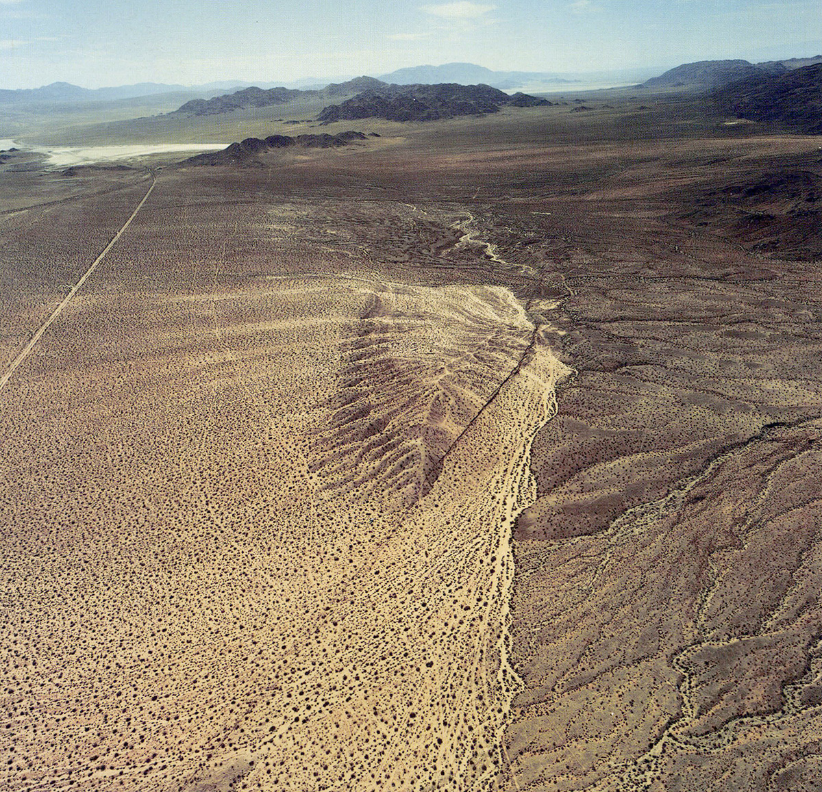 Back cover photo: Surface rupture along Emerson Fault south of unpaved Galway Lake Road. Galway Lake playa is visible near the upper left corner of the photo. Zone of surface rupture is the dark line extending from the lower left corner to the upper right corner. View to southeast. Click/tap the image to open a larger version in a new window. Photo courtesy of I.K. Curtis Services, Inc., July 3, 1992.
