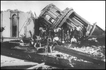
 Shaking damage at Santa Rosa City Hall caused by the April 1906 San Francisco earthquake (Magnitude 7.9).
Photo from Steinbrugge Collection, National Information Service for Earthquake Enginnering, Pacific Earthquake Engineering Research Center, University of California, Berkeley.
Shaking damage at Santa Rosa City Hall caused by the April 1906 San Francisco earthquake (Magnitude 7.9).
Photo from Steinbrugge Collection, National Information Service for Earthquake Enginnering, Pacific Earthquake Engineering Research Center, University of California, Berkeley.
Earthquake Catalogs and Other Earthquake Lists
- If you're looking for a comprehensive system of record, you should go immediately to the ANSS Comprehensive Earthquake Catalog (ComCat).
- For a quick fix, here is a catalog of magnitude 4+ earthquakes from 1769 to 2012 courtesy of the Uniform California Earthquake Rupture Forecast, Version 3 (UCERF3). If you use this catalog, you will also need Appendix K of the UCERF3 (Felzer, 2013), and Appendix H of the UCERF2 (Felzer and Cao, 2008).
- On the other hand, if you want a casual, easy to read list, here's a simple table of significant California earthquakes from 1700 to the present.
- You might enjoy our Historic Earthquakes interactive map, documenting the effects of notable historical California earthquakes as reported by the people who survived the experience. By selecting an earthquake on the map, you can see where it was felt, and the effects reported at those locations.
- We also offer a downloadable list of magnitude 5.0 and greater earthquakes from 1800 to July 2017. This list is an expanded version of the one used to create Map Sheet 49 (Epicenters of and Areas Damaged by M>=5 California Earthquakes, 1800-1999). Please read the data license agreement near the bottom of this page if you plan to use this file.
- And here's a downloadable list of Fault Source Points. Please read the data license agreement near the bottom of this page if you plan to use this file.
Map Sheet 49: Epicenters and Areas Damaged by M>=5 California Earthquakes, 1800-1999
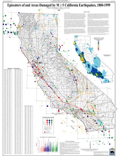 Map Sheet 49, Epicenters of and Areas Damaged by M>=5 California Earthquakes, 1800-1999 shows epicenters of potentially damaging earthquakes, magnitude 5 or greater, which occurred in California from 1800 through 1999. In addition, an inset map shows areas that had been damaged by earthquakes of magnitude 7 or greater, and the minimum number of times such damage had occurred. The map measures 27 inches by 37 inches.
The 200-year earthquake history is divided into three nearly equal time periods, distinguished by red, blue and green on the epicenter map and bar graph, to show the changes in earthquake occurrence and identification with time.
The map shows that since 1800, earthquakes capable of damaging unreinforced buildings have occurred at least six times in each of these regions: Los Angeles to San Fernando, San Francisco Bay to Santa Cruz, and Eureka to Cape Mendocino. The epicenters of 800 temblors are shown, including some centered offshore of California, as well as bordering regions of Nevada, Oregon and Mexico. A list of earthquakes of magnitude 5.5 and greater, sorted by latitude for easy locating, is included on the map.
California Geological Survey seismologists compared old newspaper and other written accounts of earthquake shaking with accounts of the shaking from earthquakes recorded by modern instruments to determine the most likely epicenters and magnitudes of pre-1932 earthquakes. Most of the information about earthquakes that occurred before the 1849 gold rush comes from reports from the 21 missions near the coast from San Diego to Sonoma. Information about earthquakes from 1850 to 1931 is based largely on newspaper reports. Post-1932 data is from the seismological laboratories at Caltech and UC Berkeley, which began to routinely determine the epicenters and magnitudes of earthquakes in Southern and Northern California, respectively, in 1932 and 1942, supplemented by data from the United States Geological Survey starting in the 1970s. As California's population increased and spread across the state, earthquakes began to be reported in new areas — a fact that is reflected in the color-coded map.
The map indicates that California, on the average, has experienced one magnitude 6 or greater earthquake each year since 1850. It also shows that some areas have been relatively quiet seismically in the last 90 years but were very active in the previous 100 years. The relatively quiet areas include the San Andreas system of faults, which includes the San Jacinto and the Hayward-Rodgers Creek faults. Strong earthquakes also have occurred away from major known surface faults, such as near Vacaville in the Sacramento Valley in 1892.
License/Use Agreement for California Earthquake Catalogs
The California Department of Conservation's (DOC) California Geological Survey (CGS) and the user choose to enter into this License/Use Agreement to utilize digital files of the earthquake catalogs of California. The files will be provided by DOC/CGS subject to the following conditions:
- Ownership and the distribution rights of the files remain with DOC/CGS. This information was produced by the Department of Conservation, California Geological Survey and is protected by the United States Copyright Law. For information, contact the California Department of Conservation, California Geological Survey.
- The user agrees to report any errors found on the files to DOC/CGS.
- The user agrees to acknowledge the California Department of Conservation's California Geological Survey in any publication or report that utilizes the data. If the user modifies the catalog in any way, the user agrees to note that the data are modified from the California Department of Conservation's California Geological Survey earthquake catalog.
- This information was developed by the DOC/CGS. It is a compilation of data from several seismic networks including: U.S. Geological Survey, California Institute of Technology, University of Nevada-Reno, University of California-Berkeley. For this catalog several different magnitude scales are used. In addition, some events may be missing from the catalog since an algorithm was applied to the catalogs to remove duplicates. Some of the "duplicates" that were removed may have been real events. The uncertainties in locations of earthquakes varies with each of the different networks and with time.
- THE EARTHQUAKE CATALOG DATA OF CALIFORNIA ARE PROVIDED "AS IS" WITHOUT EXPRESS OR IMPLIED WARRANTY INCLUDING, BUT NOT LIMITED TO, THE IMPLIED WARRANTIES OF MERCHANTABILITY AND FITNESS FOR A PARTICULAR PURPOSE. IN NO EVENT WILL DOC/CGS OR ANY OTHER CONTRIBUTOR BE LIABLE TO ANY OTHER PARTY FOR DIRECT, INCIDENTAL OR CONSEQUENTIAL DAMAGES, INCLUDING BUT NOT LIMITED TO TIME, MONEY, OR GOOD WILL, ARISING FROM THE USE, DISTRIBUTION, OPERATION OR MODIFICATION OF THE DATA, EVEN IF DOC/CGS HAS BEEN ADVISED OF THE POSSIBILITY OF SUCH DAMAGE. IN NO EVENT SHOULD EITHER PARTY BE LIABLE TO THE OTHER FOR INDIRECT, SPECIAL, OR CONSEQUENTIAL DAMAGES OR CLAIMS FROM ANY SOURCE ARISING FROM THIS AGREEMENT.
License/Use Agreement for Fault Source Points
The California Department of Conservation's (DOC) California Geological Survey (CGS) and the user choose to enter into this License/Use Agreement to utilize digital files of the earthquake source points of California. The files will be provided by DOC/CGS subject to the following conditions:
- Ownership and the distribution rights of the files remain with DOC/CGS. This information was produced all or in part from the digital data of the Department of Conservation, California Geological Survey and is protected by the United States Copyright Law. For information, contact the California Department of Conservation, California Geological Survey.
- The user agrees to report any errors found on the files to DOC/CGS.
- The user agrees to acknowledge the California Department of Conservation's California Geological Survey in any publication or report that utilizes the data. If the data are modified in any way, the user agrees to note that the data are modified from the California Department of Conservation's California Geological Survey data.
- This information was developed by the DOC/CGS. It was digitized recently and has not yet been proofed for accuracy. The earthquake source information was digitized from the California Geological Survey's Fault Activity Map of California and Adjacent Areas by Charles Jennings, published in 1994. The Jennings fault map was compiled and published at a scale of 1:750,000, therefore, 1 km on the ground is represented by about 1.3 mm (less than 1/16 inch) on the map. Source point locations may be uncertain by 1 to 2 km.
- THE FAULT POINTS OF CALIFORNIA ARE PROVIDED "AS IS" WITHOUT EXPRESS OR IMPLIED WARRANTY INCLUDING, BUT NOT LIMITED TO, THE IMPLIED WARRANTIES OF MERCHANTABILITY AND FITNESS FOR A PARTICULAR PURPOSE. IN NO EVENT WILL DOC/CGS OR ANY OTHER CONTRIBUTOR BE LIABLE TO ANY OTHER PARTY FOR DIRECT, INCIDENTAL OR CONSEQUENTIAL DAMAGES, INCLUDING BUT NOT LIMITED TO TIME, MONEY, OR GOOD WILL, ARISING FROM THE USE, DISTRIBUTION, OPERATION OR MODIFICATION OF THE DATA, EVEN IF DOC/CGS HAS BEEN ADVISED OF THE POSSIBILITY OF SUCH DAMAGE. IN NO EVENT SHOULD EITHER PARTY BE LIABLE TO THE OTHER FOR INDIRECT, SPECIAL, OR CONSEQUENTIAL DAMAGES OR CLAIMS FROM ANY SOURCE ARISING FROM THIS AGREEMENT.
