About Us
The CGS Forest and Watershed Geology Program (FWGP) provides technical information and advice about erosion, sedimentation, landslides, and other geologic hazards on California's forested lands and in watersheds where land-use decisions may affect water quality and fish habitat.
Timber Harvest Plan Review
The Timber Harvest Plan (THP) Review Projects provide engineering geologic review of proposed THPs, Non-Industrial Timberland Management Plans (NTMPs), and other regional-scale land management projects submitted to the CDF under the 1973 Z’Berg-Nejedley Forest Practice Act and Rules. CGS has provided advisory comments to CDF and the Board of Forestry regarding geologic and slope stability concerns since 1975. The three THP Review Projects are: THP Review Sacramento, THP Review Santa Rosa, and THP Review Eureka.
Watershed Restoration

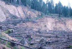
The Watershed Restoration Project provides site specific landslide mapping, engineering geologic review, and analysis of geomorphic processes for various state agencies. The Watershed Restoration Project also provides advice and technic al information to various state agencies in their decision-making for future site-specific restoration project planning issues related to sediment sources, slope stability, water quality, cumulative watershed effects and fish habitat.
Road/Trail Erosion Assessments
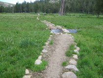
Road and trail assessments range from basic inventories to comprehensive documentation of erosion, altered hydrology, and recommended treatments. As roads and trails are lineal features, the data is collected, calibrated, and stored as such allowing the ready production of maps showing current conditions, or treatments, or both. Where high quality GPS -based maps of subject roads/trails are lacking, CGS produces the needed centerline maps. Different areas are managed or have been used differently resulting in a variety of ancillary features of interest. CGS can customize methodologies to incorporate such elements into a road/trail assessment. These assessments document, at ground-level, the interaction of roads, trail, and watercourses with the landscape. Resurveys will provide meaningful change detection. Improvements, deterioration, and responses to treatments and their costs can be documented. The pairing of these assessments with various landscape data in the geographic information system provides a comprehensive state-of-the-art evaluation of land use effects. Through monitoring, periodic updates, and reassessments the cost-benefit analyses often required by grant providers and regulators become highly credible.
Off-Highway Vehicle Park Soil Guidelines Project
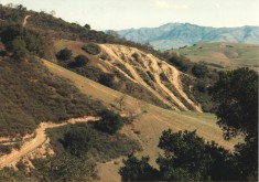
CGS is under contract with California State Parks to update the 1991 Soil Conservation Guidelines/Standards for Off-Highway Vehicle (OHV) Recreation Management. With the increase in OHV use on California state and federal lands, the updated guidelines must be flexible enough to apply to all sites statewide, ecosystems with multiple soils types and a variety of vehicle uses. The focus is to allow for restoration as well as providing sustainability of trail systems and recreational opportunities. As part of the update, CGS is compiling a statewide index of geology and soils data for each OHV area; conducting three pilot studies to test proposed guidelines revisions; and providing training for individuals responsible for implementation and monitoring. Public input regarding proposed changes will be obtained through a series of public workshops. Technical advice will also be provided by a Consulting Agency Review Committee.
Geologic Reviews
CGS's FWGP staff prepare memoranda documenting their geologic reviews of various types of Timber Harvest Plans, regional scale forest management plans, and watershed restoration projects. These review memoranda are submitted to the appropriate lead agency for incorporation into the project decision-making process. Copies of recent available geologic reviews and other FWGP-prepared documents are available on our Documents page.
Watershed Maps, GIS Data, and Other Publications
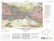
The FWGP staff prepares various geologic and landslide maps and publications related to forested areas within the state. To download printable maps or GIS data please go to our FWGP Maps and Data page.
